TopoQuest Logo
Do you find TopoQuest useful?
Help keep TopoQuest running and adding new maps/features by donating!
Bitcoin:  19c7KJd3qBynnjoSw5npx9KScwjBe4ifkT
Litecoin:  LXs6TkuXGGXo1vDsWCkWVdjQX94eUKd6ui
Home View Maps Find Maps Find Places Resources & Links


Freedom, Oklahoma Topographic Map

USGS Map Title: Freedom, OK
USGS Map MRC: 36099G1
DRG (GeoTIFF) Download: o36099g1.tif


Neighboring USGS Topographic Map Quads:


  Freedom NW, OK  
36099H2
 

  Freedom NE, OK  
36099H1
 

  Tegarden NW, OK  
36098H8
 

  Edith, OK  
36099G2
 

  Freedom, OK  
36099G1
 

  Tegarden, OK  
36098G8
 

  Alabaster Caverns, OK  
36099F2
 

  Fairvalley, OK  
36099F1
 

  Waynoka NW, OK  
36098F8


Map MRC Location:

N37°
W100°
N37°
W99°
H8 H7 H6 H5 H4 H3 H2 H1
G8 G7 G6 G5 G4 G3 G2 G1
F8 F7 F6 F5 F4 F3 F2 F1
E8 E7 E6 E5 E4 E3 E2 E1
D8 D7 D6 D5 D4 D3 D2 D1
C8 C7 C6 C5 C4 C3 C2 C1
B8 B7 B6 B5 B4 B3 B2 B1
A8 A7 A6 A5 A4 A3 A2 A1
N36°
W100°
N36°
W99°

Freedom, OK USGS 1:24K Topographic Map Preview:
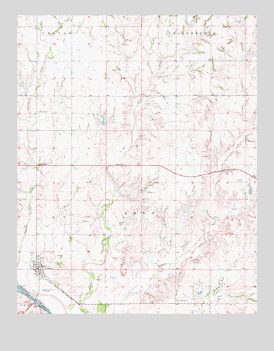
Freedom, OK USGS Topographic Map
Click on map above to begin viewing in our Map Viewer.

This topographic map contains these locations and features:
Feature Name Type Latitude Longitude GNIS ID View Map
Anderson CreekStreamN36.7523°W99.1001°1089628View Map
Benson Number 3 DamDamN36.7717°W99.0254°1751246View Map
Benson Number 3 ReservoirReservoirN36.7717°W99.0254°1751247View Map
Bull CreekStreamN36.8311°W99.0634°1090677View Map
Camp HoustonLocaleN36.8123°W99.1151°1090862View Map
Eden Ranch Airport (historical)AirportN36.7584°W99.0340°1102475View Map
Fairvalley CemeteryCemeteryN36.7556°W99.0423°1092704View Map
Farry SchoolSchoolN36.8567°W99.0248°1092770View Map
FreedomPopulated PlaceN36.7689°W99.1129°1093038View Map
Freedom CemeteryCemeteryN36.8345°W99.1145°1093039View Map
Freedom Elementary SchoolSchoolN36.7701°W99.1123°1793676View Map
Freedom High SchoolSchoolN36.7702°W99.1124°1790340View Map
Freedom Municipal AirportAirportN36.7591°W99.1017°1102476View Map
Freedom Post OfficePost OfficeN36.7689°W99.1147°1814145View Map
Freedom Volunteer Ambulance ServiceBuildingN36.7684°W99.1136°2695939View Map
Freedom Volunteer Fire DepartmentBuildingN36.7684°W99.1136°2658476View Map
Girl CreekStreamN36.7598°W99.1237°1093192View Map
Oknoname 151002 DamDamN36.8134°W99.0037°1755240View Map
Oknoname 151002 ReservoirReservoirN36.8134°W99.0037°1755241View Map
Preston Hill CemeteryCemeteryN36.8406°W99.0270°1096924View Map
Rhodes ParkParkN36.7753°W99.1179°1097185View Map
Town of FreedomCivilN36.7681°W99.1131°2412658View Map
Township of PennCivilN36.7778°W99.0726°1825429View Map
Woods County Sheriff's OfficeBuildingN36.7688°W99.1150°2757588View Map

Note: Coordinates in the location and feature list above are referenced to NAD83 datum.


Copyright (C) 2008-2025 Ryan Niemi / Sunset Dynamics ... All Rights Reserved