TopoQuest Logo
Do you find TopoQuest useful?
Help keep TopoQuest running and adding new maps/features by donating!
Bitcoin:  19c7KJd3qBynnjoSw5npx9KScwjBe4ifkT
Litecoin:  LXs6TkuXGGXo1vDsWCkWVdjQX94eUKd6ui
Home View Maps Find Maps Find Places Resources & Links


Friendship, South Carolina Topographic Map

USGS Map Title: Friendship, SC
USGS Map MRC: 34079A4
DRG (GeoTIFF) Download: o34079a4.tif


Neighboring USGS Topographic Map Quads:


  Pee Dee, SC  
34079B5
 

  Marion, SC  
34079B4
 

  Mullins, SC  
34079B3
 

  Pamplico North, SC  
34079A5
 

  Friendship, SC  
34079A4
 

  Centenary, SC  
34079A3
 

  Pamplico South, SC  
33079H5
 

  Gresham, SC  
33079H4
 

  Brittons Neck, SC  
33079H3


Map MRC Location:

N35°
W80°
N35°
W79°
H8 H7 H6 H5 H4 H3 H2 H1
G8 G7 G6 G5 G4 G3 G2 G1
F8 F7 F6 F5 F4 F3 F2 F1
E8 E7 E6 E5 E4 E3 E2 E1
D8 D7 D6 D5 D4 D3 D2 D1
C8 C7 C6 C5 C4 C3 C2 C1
B8 B7 B6 B5 B4 B3 B2 B1
A8 A7 A6 A5 A4 A3 A2 A1
N34°
W80°
N34°
W79°

Friendship, SC USGS 1:24K Topographic Map Preview:
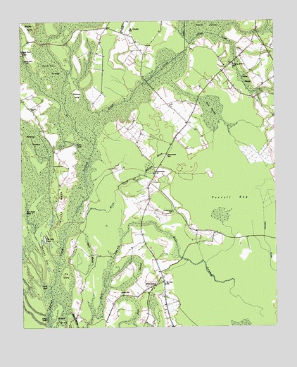
Friendship, SC USGS Topographic Map
Click on map above to begin viewing in our Map Viewer.

This topographic map contains these locations and features:
Feature Name Type Latitude Longitude GNIS ID View Map
Baker LakeLakeN34.0748°W79.4731°1220303View Map
Beverly SwampSwampN34.0597°W79.4934°1220648View Map
Big IslandIslandN34.0216°W79.4784°1220710View Map
Buck CoveSwampN34.0154°W79.4889°1221066View Map
Centenary DivisionCivilN34.0288°W79.3963°1938220View Map
Collins CreekStreamN34.1157°W79.4162°1221688View Map
Collins SwampSwampN34.1010°W79.3887°1221690View Map
Dickerson IslandIslandN34.0952°W79.4720°1222017View Map
Flat SwampSwampN34.0896°W79.4059°1222446View Map
Ford CemeteryCemeteryN34.0140°W79.4512°1222481View Map
Ford SwampSwampN34.0177°W79.4484°1222483View Map
FriendshipPopulated PlaceN34.0168°W79.4353°1222566View Map
Friendship ChurchChurchN34.0160°W79.4381°1244041View Map
Friendship ChurchChurchN34.0188°W79.4303°1230799View Map
Heaven HillSummitN34.0288°W79.4887°1231371View Map
Kirton CemeteryCemeteryN34.0652°W79.4523°1223752View Map
Long LakeLakeN34.0017°W79.4868°1224173View Map
Lower Ford LakeLakeN34.1088°W79.4980°1224209View Map
Marion Gresham Lookout TowerTowerN34.1041°W79.4023°1230815View Map
Millrace DrainStreamN34.0621°W79.4392°1224577View Map
Mink CreekStreamN34.0438°W79.4698°1224592View Map
Mose IslandsIslandN34.0035°W79.4831°1224642View Map
Pitch Pot SwampSwampN34.0880°W79.4711°1250146View Map
Rye Ridge PondLakeN34.0476°W79.4977°1226086View Map
Saint Paul SchoolSchoolN34.0177°W79.4295°1226233View Map
Saint Timothy ChurchChurchN34.1213°W79.4456°1226277View Map
Sara LakeLakeN34.0017°W79.4868°1226399View Map
Small MarshSwampN34.0313°W79.4662°1226677View Map
TabernaclePopulated PlaceN34.0588°W79.4362°1230854View Map
Tabernacle CemeteryCemeteryN34.0471°W79.4251°1227011View Map
Tabernacle ChurchChurchN34.0704°W79.4281°1230855View Map
Tabernacle ChurchChurchN34.0635°W79.4339°1227013View Map
Tabernacle SchoolSchoolN34.0699°W79.4278°1227018View Map
Ten Acre PondLakeN34.0363°W79.4885°1227058View Map
Terrell BayBasinN34.0527°W79.3948°1227061View Map
Upper Ford LakeLakeN34.1125°W79.4989°1227319View Map
Wahee CemeteryCemeteryN34.0663°W79.4837°1227368View Map
Wahee CemeteryCemeteryN34.0896°W79.4951°1227369View Map
Wahee Church (historical)ChurchN34.0910°W79.4948°1230858View Map
Wahee NeckCapeN34.0496°W79.4806°1227370View Map
Weeping Willow ChurchChurchN34.1082°W79.3948°1230861View Map
Weeping Willow SchoolSchoolN34.1071°W79.3953°1227466View Map

Note: Coordinates in the location and feature list above are referenced to NAD83 datum.


Copyright (C) 2008-2025 Ryan Niemi / Sunset Dynamics ... All Rights Reserved