TopoQuest Logo
Do you find TopoQuest useful?
Help keep TopoQuest running and adding new maps/features by donating!
Bitcoin:  19c7KJd3qBynnjoSw5npx9KScwjBe4ifkT
Litecoin:  LXs6TkuXGGXo1vDsWCkWVdjQX94eUKd6ui
Home View Maps Find Maps Find Places Resources & Links


Frink, Florida Topographic Map

USGS Map Title: Frink, FL
USGS Map MRC: 30085C2
DRG (GeoTIFF) Download: o30085c2.tif


Neighboring USGS Topographic Map Quads:


  Clarksville, FL  
30085D2
 

  Blountstown, FL  
30085D1


  Frink, FL  
30085C2
 

  Estiffanulga, FL  
30085C1


  Dead Lakes, FL  
30085B2
 

  Orange, FL  
30085B1


Map MRC Location:

N31°
W86°
N31°
W85°
H8 H7 H6 H5 H4 H3 H2 H1
G8 G7 G6 G5 G4 G3 G2 G1
F8 F7 F6 F5 F4 F3 F2 F1
E8 E7 E6 E5 E4 E3 E2 E1
D8 D7 D6 D5 D4 D3 D2 D1
C8 C7 C6 C5 C4 C3 C2 C1
B8 B7 B6 B5 B4 B3 B2 B1
A8 A7 A6 A5 A4 A3 A2 A1
N30°
W86°
N30°
W85°

Frink, FL USGS 1:24K Topographic Map Preview:
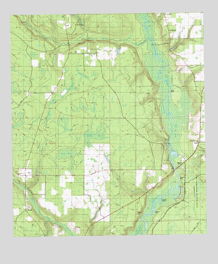
Frink, FL USGS Topographic Map
Click on map above to begin viewing in our Map Viewer.

This topographic map contains these locations and features:
Feature Name Type Latitude Longitude GNIS ID View Map
Abe SpringsPopulated PlaceN30.3658°W85.1474°295089View Map
Abe Springs ChurchChurchN30.3746°W85.1499°304782View Map
Abe Springs School (historical)SchoolN30.3724°W85.1508°294600View Map
Arron BaySwampN30.2953°W85.2140°304786View Map
Blazed Pine LandingLocaleN30.2633°W85.1580°295137View Map
Boggy BranchStreamN30.3616°W85.1991°279159View Map
Carter LandingLocaleN30.2924°W85.1480°295182View Map
Cedar BluffBendN30.3313°W85.1466°304788View Map
Chessar LandingLocaleN30.2716°W85.1427°301112View Map
Chipola RiverStreamN30.2583°W85.1652°280404View Map
Coconut BluffCliffN30.2810°W85.1413°280616View Map
Cypress Creek ChurchChurchN30.2849°W85.2469°281207View Map
Dunham BranchStreamN30.2596°W85.2274°281871View Map
Flat CreekStreamN30.2741°W85.1630°304783View Map
Fox PondSwampN30.3344°W85.2099°282773View Map
FrinkPopulated PlaceN30.3685°W85.2141°294779View Map
Frink ChurchChurchN30.3533°W85.2069°282836View Map
Frozen BluffCliffN30.2635°W85.1666°282843View Map
GaskinsPopulated PlaceN30.3058°W85.1266°301113View Map
Graham BaySwampN30.2983°W85.1944°295789View Map
Green BaySwampN30.3235°W85.2252°283369View Map
Gum BaySwampN30.3410°W85.1957°283521View Map
Iolee (historical)Populated PlaceN30.2669°W85.1332°294504View Map
Jack LakeLakeN30.3396°W85.1491°304785View Map
Juniper CreekStreamN30.3613°W85.1608°284996View Map
Kinard Volunteer Fire DepartmentBuildingN30.2654°W85.2422°2644495View Map
Long PondSwampN30.3408°W85.2036°286065View Map
McClellan CemeteryCemeteryN30.3594°W85.2005°286575View Map
Mill CreekStreamN30.3521°W85.1546°304784View Map
Pitts Mill CreekStreamN30.2769°W85.2410°289010View Map
Pitts Mill Pond (historical)SwampN30.2871°W85.2338°294605View Map
Red Bug IslandIslandN30.2696°W85.1544°289537View Map
Scotts FerryPopulated PlaceN30.2955°W85.1316°301114View Map
Scotts Ferry Volunteer Fire DepartmentBuildingN30.2907°W85.1388°2644496View Map
Smith Fire Tower (historical)TowerN30.3321°W85.2385°294606View Map
Smith LandingLocaleN30.3005°W85.1494°295636View Map
Ward LakeLakeN30.3080°W85.1435°304787View Map
West Bay BridgeBridgeN30.2946°W85.2291°303574View Map
Williams Memorial ChurchChurchN30.3024°W85.1296°304781View Map
Woods Fish Camp (historical)LocaleN30.3577°W85.1602°304079View Map
WPAP-FM (Panama City)TowerN30.3683°W85.2066°309096View Map

Note: Coordinates in the location and feature list above are referenced to NAD83 datum.


Copyright (C) 2008-2024 Ryan Niemi / Sunset Dynamics ... All Rights Reserved