TopoQuest Logo
Do you find TopoQuest useful?
Help keep TopoQuest running and adding new maps/features by donating!
Bitcoin:  19c7KJd3qBynnjoSw5npx9KScwjBe4ifkT
Litecoin:  LXs6TkuXGGXo1vDsWCkWVdjQX94eUKd6ui
Home View Maps Find Maps Find Places Resources & Links


Frutosa Lake, New Mexico Topographic Map

USGS Map Title: Frutosa Lake, NM
USGS Map MRC: 35104G6
DRG (GeoTIFF) Download: o35104g6.tif


Neighboring USGS Topographic Map Quads:


  Optimo, NM  
35104H7
 

  Mogote Hills, NM  
35104H6
 

  Alamosa Creek, NM  
35104H5
 

  Cherry Valley Lake, NM  
35104G7
 

  Frutosa Lake, NM  
35104G6
 

  Canon Ancho, NM  
35104G5
 

  Canon Pedroso, NM  
35104F7
 

  Llonidas Lake, NM  
35104F6
 

  Maes, NM  
35104F5


Map MRC Location:

N36°
W105°
N36°
W104°
H8 H7 H6 H5 H4 H3 H2 H1
G8 G7 G6 G5 G4 G3 G2 G1
F8 F7 F6 F5 F4 F3 F2 F1
E8 E7 E6 E5 E4 E3 E2 E1
D8 D7 D6 D5 D4 D3 D2 D1
C8 C7 C6 C5 C4 C3 C2 C1
B8 B7 B6 B5 B4 B3 B2 B1
A8 A7 A6 A5 A4 A3 A2 A1
N35°
W105°
N35°
W104°

Frutosa Lake, NM USGS 1:24K Topographic Map Preview:
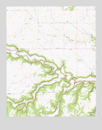
Frutosa Lake, NM USGS Topographic Map
Click on map above to begin viewing in our Map Viewer.

This topographic map contains these locations and features:
Feature Name Type Latitude Longitude GNIS ID View Map
AllenLocaleN35.7670°W104.7394°924330View Map
Berlier RanchLocaleN35.8528°W104.7047°886241View Map
Bucher WindmillLocaleN35.8378°W104.7061°886823View Map
Cabra SpringSpringN35.8084°W104.6703°887057View Map
Caņon CarrisoValleyN35.7892°W104.6539°897794View Map
Caņon CiboloValleyN35.7953°W104.6669°897797View Map
Caņon PinabeteValleyN35.7887°W104.6330°897838View Map
CappsLocaleN35.8520°W104.7014°924333View Map
Doolin WindmillLocaleN35.8270°W104.6789°888463View Map
Elijid WindmillLocaleN35.8259°W104.6608°888844View Map
Frutosa LakeLakeN35.8136°W104.6460°889253View Map
Garza CanyonValleyN35.8009°W104.6861°889371View Map
Harman WindmillLocaleN35.8264°W104.6972°889781View Map
Mejan MesaSummitN35.7767°W104.7258°891834View Map
Mobil 1 WigginsMineN35.8606°W104.6575°917251View Map
Morrison LakeLakeN35.8604°W104.7195°892243View Map
Morrison WindmillLocaleN35.8553°W104.7239°892245View Map
Pedroso CreekStreamN35.7953°W104.6669°897435View Map
Pinos AltosAreaN35.7948°W104.6878°893319View Map
Taylor WindmillLocaleN35.8378°W104.7275°895551View Map
Wiggins RanchLocaleN35.8575°W104.6655°896580View Map

Note: Coordinates in the location and feature list above are referenced to NAD83 datum.


Copyright (C) 2008-2025 Ryan Niemi / Sunset Dynamics ... All Rights Reserved