TopoQuest Logo
Do you find TopoQuest useful?
Help keep TopoQuest running and adding new maps/features by donating!
Bitcoin:  19c7KJd3qBynnjoSw5npx9KScwjBe4ifkT
Litecoin:  LXs6TkuXGGXo1vDsWCkWVdjQX94eUKd6ui
Home View Maps Find Maps Find Places Resources & Links


Fulton, Arkansas Topographic Map

USGS Map Title: Fulton, AR
USGS Map MRC: 33093E7
DRG (GeoTIFF) Download: o33093e7.tif


Neighboring USGS Topographic Map Quads:


  Red Bluff, AR  
33093F8
 

  McNab, AR  
33093F7
 

  Sheppard, AR  
33093F6
 

  Homan, AR  
33093E8
 

  Fulton, AR  
33093E7
 

  Spring Hill, AR  
33093E6
 

  Mandeville, AR  
33093D8
 

  Fouke NE, AR  
33093D7
 

  Boyd Hill, AR  
33093D6


Map MRC Location:

N34°
W94°
N34°
W93°
H8 H7 H6 H5 H4 H3 H2 H1
G8 G7 G6 G5 G4 G3 G2 G1
F8 F7 F6 F5 F4 F3 F2 F1
E8 E7 E6 E5 E4 E3 E2 E1
D8 D7 D6 D5 D4 D3 D2 D1
C8 C7 C6 C5 C4 C3 C2 C1
B8 B7 B6 B5 B4 B3 B2 B1
A8 A7 A6 A5 A4 A3 A2 A1
N33°
W94°
N33°
W93°

Fulton, AR USGS 1:24K Topographic Map Preview:
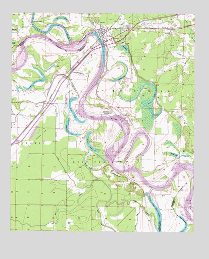
Fulton, AR USGS Topographic Map
Click on map above to begin viewing in our Map Viewer.

This topographic map contains these locations and features:
Feature Name Type Latitude Longitude GNIS ID View Map
Adams Cut-off LakeLakeN33.5848°W93.8598°74624View Map
Bluff LakeSwampN33.5374°W93.8216°46776View Map
Bois d'Arc BayouStreamN33.5296°W93.8157°46815View Map
Bushy LakeLakeN33.5447°W93.7638°74723View Map
Buzzard BluffCliffN33.5312°W93.7968°76480View Map
Charity ChurchChurchN33.5673°W93.7966°47705View Map
ClipperPopulated PlaceN33.5721°W93.8532°56962View Map
Duck PondLakeN33.5699°W93.7805°74806View Map
Finn BayouStreamN33.5012°W93.7749°76923View Map
Fish LakeLakeN33.5443°W93.7545°74828View Map
FultonPopulated PlaceN33.6146°W93.8135°49291View Map
Fulton CemeteryCemeteryN33.6198°W93.8155°49292View Map
Fulton Post OfficePost OfficeN33.6133°W93.8153°2740751View Map
Fulton Volunteer Fire DepartmentBuildingN33.6136°W93.8151°2116463View Map
Galilee ChurchChurchN33.6137°W93.7663°49309View Map
Horseshoe LakeSwampN33.6153°W93.8743°50342View Map
Interchange 12CrossingN33.5498°W93.8749°58933View Map
Interchange 18CrossingN33.6107°W93.7996°58934View Map
Kuykendall LakeLakeN33.5567°W93.8353°74938View Map
Lake VaughnLakeN33.6223°W93.8416°75199View Map
Little RiverStreamN33.6098°W93.8257°72417View Map
Mud LakeLakeN33.6054°W93.7975°75039View Map
Old Allens FerryLocaleN33.6210°W93.8605°77898View Map
Old River LakeLakeN33.5888°W93.7989°77911View Map
Red Hill CemeteryCemeteryN33.6101°W93.8041°53947View Map
Red LakeLakeN33.5728°W93.7827°78144View Map
Red Lake School (historical)SchoolN33.5787°W93.7760°61541View Map
Scott LakeLakeN33.5688°W93.8335°75119View Map
SprudelPopulated PlaceN33.6165°W93.7666°57194View Map
Summers IslandIslandN33.5168°W93.7705°61540View Map
Town of FultonCivilN33.6126°W93.8137°2406531View Map
Willow LakeLakeN33.5492°W93.8215°75222View Map

Note: Coordinates in the location and feature list above are referenced to NAD83 datum.


Copyright (C) 2008-2024 Ryan Niemi / Sunset Dynamics ... All Rights Reserved