TopoQuest Logo
Do you find TopoQuest useful?
Help keep TopoQuest running and adding new maps/features by donating!
Bitcoin:  19c7KJd3qBynnjoSw5npx9KScwjBe4ifkT
Litecoin:  LXs6TkuXGGXo1vDsWCkWVdjQX94eUKd6ui
Home View Maps Find Maps Find Places Resources & Links


Gallegos, New Mexico Topographic Map

USGS Map Title: Gallegos, NM
USGS Map MRC: 35103E6
DRG (GeoTIFF) Download: o35103e6.tif


Neighboring USGS Topographic Map Quads:


  Salitre Canyon, NM  
35103F7
 

  Buffalo Springs, NM  
35103F6
 

  Gallegos NE, NM  
35103F5
 

  Alamosa Canyon, NM  
35103E7
 

  Gallegos, NM  
35103E6
 

  Fuentes Ranch, NM  
35103E5
 

  Medina Mesa, NM  
35103D7
 

  Hampton Ranch, NM  
35103D6
 

  Montesito Creek, NM  
35103D5


Map MRC Location:

N36°
W104°
N36°
W103°
H8 H7 H6 H5 H4 H3 H2 H1
G8 G7 G6 G5 G4 G3 G2 G1
F8 F7 F6 F5 F4 F3 F2 F1
E8 E7 E6 E5 E4 E3 E2 E1
D8 D7 D6 D5 D4 D3 D2 D1
C8 C7 C6 C5 C4 C3 C2 C1
B8 B7 B6 B5 B4 B3 B2 B1
A8 A7 A6 A5 A4 A3 A2 A1
N35°
W104°
N35°
W103°

Gallegos, NM USGS 1:24K Topographic Map Preview:
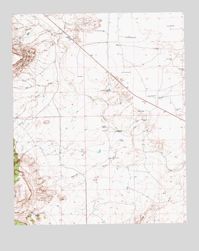
Gallegos, NM USGS Topographic Map
Click on map above to begin viewing in our Map Viewer.

This topographic map contains these locations and features:
Feature Name Type Latitude Longitude GNIS ID View Map
Antique WellWellN35.5750°W103.6511°885816View Map
Askins WellWellN35.5970°W103.6350°885924View Map
Buena Vista RanchLocaleN35.5612°W103.6535°886851View Map
Church of the Immaculate Conception Historic SiteChurchN35.6128°W103.7189°933815View Map
Clendenin WellWellN35.5662°W103.6552°887676View Map
Creek Pasture WellWellN35.5787°W103.6808°888062View Map
Deposito CreekStreamN35.6084°W103.7172°888330View Map
Flowers WellWellN35.6167°W103.6366°889110View Map
GallegosPopulated PlaceN35.6098°W103.7072°898547View Map
Gallegos Post Office (historical)Post OfficeN35.6098°W103.7072°938483View Map
Gallegos RanchLocaleN35.6128°W103.7189°889292View Map
Jones WellWellN35.6034°W103.6441°890560View Map
Lower Andrews WindmillLocaleN35.5387°W103.6814°891415View Map
Mare Pasture WellWellN35.6139°W103.6830°891594View Map
Osborn RanchLocaleN35.5875°W103.7036°892949View Map
PayneLocaleN35.5878°W103.7025°924320View Map
Pomroy RanchLocaleN35.6059°W103.6727°893396View Map
Prajetes CampLocaleN35.5553°W103.6844°893464View Map
Ramirez DrawValleyN35.5473°W103.6650°893636View Map
Ramsey WellWellN35.5909°W103.6264°893644View Map
Reed WellWellN35.5742°W103.6444°893848View Map
Rincon CreekStreamN35.5856°W103.7116°893930View Map
South House Pasture WellWellN35.6103°W103.6664°895070View Map
Tinkle WellWellN35.5673°W103.6325°895693View Map
Twin WindmillsLocaleN35.5895°W103.6700°895978View Map
Ute Creek WindmillLocaleN35.5548°W103.6747°896061View Map
VigilLocaleN35.5609°W103.6514°924326View Map

Note: Coordinates in the location and feature list above are referenced to NAD83 datum.


Copyright (C) 2008-2025 Ryan Niemi / Sunset Dynamics ... All Rights Reserved