TopoQuest Logo
Do you find TopoQuest useful?
Help keep TopoQuest running and adding new maps/features by donating!
Bitcoin:  19c7KJd3qBynnjoSw5npx9KScwjBe4ifkT
Litecoin:  LXs6TkuXGGXo1vDsWCkWVdjQX94eUKd6ui
Home View Maps Find Maps Find Places Resources & Links


Garber, Oklahoma Topographic Map

USGS Map Title: Garber, OK
USGS Map MRC: 36097D5
DRG (GeoTIFF) Download: o36097d5.tif


Neighboring USGS Topographic Map Quads:


  Hunter, OK  
36097E6
 

  Lamont SE, OK  
36097E5
 

  Billings, OK  
36097E4
 

  Breckinridge, OK  
36097D6
 

  Garber, OK  
36097D5
 

  Perry NW, OK  
36097D4
 

  Fairmont, OK  
36097C6
 

  Covington, OK  
36097C5
 

  Lucien, OK  
36097C4


Map MRC Location:

N37°
W98°
N37°
W97°
H8 H7 H6 H5 H4 H3 H2 H1
G8 G7 G6 G5 G4 G3 G2 G1
F8 F7 F6 F5 F4 F3 F2 F1
E8 E7 E6 E5 E4 E3 E2 E1
D8 D7 D6 D5 D4 D3 D2 D1
C8 C7 C6 C5 C4 C3 C2 C1
B8 B7 B6 B5 B4 B3 B2 B1
A8 A7 A6 A5 A4 A3 A2 A1
N36°
W98°
N36°
W97°

Garber, OK USGS 1:24K Topographic Map Preview:
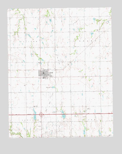
Garber, OK USGS Topographic Map
Click on map above to begin viewing in our Map Viewer.

This topographic map contains these locations and features:
Feature Name Type Latitude Longitude GNIS ID View Map
Assembly of God ChurchChurchN36.4339°W97.5828°1798221View Map
Baptist ChurchChurchN36.4334°W97.5803°1798222View Map
Blackbear CemeteryCemeteryN36.3763°W97.5059°2705340View Map
Christian ChurchChurchN36.4373°W97.5845°1798223View Map
City of GarberCivilN36.4365°W97.5809°2410566View Map
GarberPopulated PlaceN36.4370°W97.5856°1093108View Map
Garber CemeteryCemeteryN36.4419°W97.5696°2705363View Map
Garber Elementary SchoolSchoolN36.4330°W97.5835°1790661View Map
Garber Emergency Medical ServicesBuildingN36.4366°W97.5829°2695876View Map
Garber Fire DepartmentBuildingN36.4340°W97.5867°2658417View Map
Garber High SchoolSchoolN36.4331°W97.5824°1793678View Map
Garber Lutheran CemeteryCemeteryN36.4051°W97.5955°1777484View Map
Garber Police DepartmentBuildingN36.4372°W97.5830°2757587View Map
Immanuel Lutheran ChurchChurchN36.4361°W97.5845°1798224View Map
Methodist ChurchChurchN36.4370°W97.5814°1798225View Map
New Bethany ChurchChurchN36.3756°W97.5056°1095792View Map
Township of AllisonCivilN36.4639°W97.6198°1825593View Map
Township of GrantCivilN36.4639°W97.5198°1825594View Map
Township of LincolnCivilN36.3806°W97.6198°1825609View Map
Township of OliveCivilN36.3806°W97.5142°1825610View Map
Union SchoolLocaleN36.4773°W97.5500°1099174View Map
Upper Black Bear Creek Site 27 DamDamN36.3767°W97.5153°1757029View Map
Upper Black Bear Creek Site 27 ReservoirReservoirN36.3788°W97.5163°1757030View Map
Upper Black Bear Creek Site 28 DamDamN36.3784°W97.5337°1757027View Map
Upper Black Bear Creek Site 28 ReservoirReservoirN36.3808°W97.5348°1757028View Map
Upper Black Bear Creek Site 29 DamDamN36.3950°W97.5570°1757025View Map
Upper Black Bear Creek Site 29 ReservoirReservoirN36.3955°W97.5593°1757026View Map
Upper Black Bear Creek Site 30 DamDamN36.3934°W97.5937°1757023View Map
Upper Black Bear Creek Site 30 ReservoirReservoirN36.3949°W97.5940°1757024View Map
Upper Red Rock Creek Site 37 DamDamN36.4984°W97.6203°1758950View Map
Upper Red Rock Creek Site 41 DamDamN36.4900°W97.5753°1758944View Map
Upper Red Rock Creek Site 41 ReservoirReservoirN36.4882°W97.5736°1758945View Map
Upper Red Rock Creek Site 44 DamDamN36.4900°W97.5187°1758938View Map
Upper Red Rock Creek Site 44 ReservoirReservoirN36.4900°W97.5187°1758939View Map
Upper Red Rock Creek Site 45 DamDamN36.4750°W97.5220°1758936View Map
Upper Red Rock Creek Site 45 ReservoirReservoirN36.4749°W97.5241°1758937View Map

Note: Coordinates in the location and feature list above are referenced to NAD83 datum.


Copyright (C) 2008-2025 Ryan Niemi / Sunset Dynamics ... All Rights Reserved