TopoQuest Logo
Do you find TopoQuest useful?
Help keep TopoQuest running and adding new maps/features by donating!
Bitcoin:  19c7KJd3qBynnjoSw5npx9KScwjBe4ifkT
Litecoin:  LXs6TkuXGGXo1vDsWCkWVdjQX94eUKd6ui
Home View Maps Find Maps Find Places Resources & Links


Garden Spring Canyon, New Mexico Topographic Map

USGS Map Title: Garden Spring Canyon, NM
USGS Map MRC: 33106G3
DRG (GeoTIFF) Download: o33106g3.tif


Neighboring USGS Topographic Map Quads:


  Wrye Peak NW, NM  
33106H4
 

  Wrye Peak, NM  
33106H3
 

  Cooper Canyon, NM  
33106H2
 

  Wrye Peak SW, NM  
33106G4
 

  Garden Spring Canyon, NM  
33106G3
 

  Pink Peak, NM  
33106G2
 

  Trinity Site, NM  
33106F4
 

  Oscura Peak, NM  
33106F3
 

  Red Canyon, NM  
33106F2


Map MRC Location:

N34°
W107°
N34°
W106°
H8 H7 H6 H5 H4 H3 H2 H1
G8 G7 G6 G5 G4 G3 G2 G1
F8 F7 F6 F5 F4 F3 F2 F1
E8 E7 E6 E5 E4 E3 E2 E1
D8 D7 D6 D5 D4 D3 D2 D1
C8 C7 C6 C5 C4 C3 C2 C1
B8 B7 B6 B5 B4 B3 B2 B1
A8 A7 A6 A5 A4 A3 A2 A1
N33°
W107°
N33°
W106°

Garden Spring Canyon, NM USGS 1:24K Topographic Map Preview:
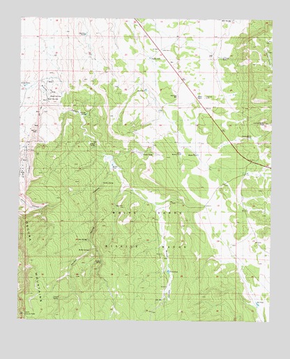
Garden Spring Canyon, NM USGS Topographic Map
Click on map above to begin viewing in our Map Viewer.

This topographic map contains these locations and features:
Feature Name Type Latitude Longitude GNIS ID View Map
A F Baca Water WellWellN33.7626°W106.3186°926055View Map
Adobe Post Office (historical)Post OfficeN33.8623°W106.3050°937733View Map
Adobe RanchLocaleN33.8623°W106.3050°902158View Map
Aperson TankReservoirN33.8684°W106.3435°933970View Map
Baca HouseBuildingN33.7609°W106.3028°885969View Map
Baca TankReservoirN33.7592°W106.3036°885973View Map
Baca WellWellN33.7590°W106.3039°901543View Map
Brush TankReservoirN33.7705°W106.3010°886798View Map
Bruton TankReservoirN33.8144°W106.3293°886810View Map
Burrego SpringSpringN33.8345°W106.3422°886954View Map
Chicken SpringSpringN33.7737°W106.3342°933976View Map
CoanePopulated PlaceN33.8009°W106.3272°898745View Map
Cooper TanksReservoirN33.8185°W106.3147°887816View Map
Council SpringSpringN33.7593°W106.3580°887958View Map
Deer SpringSpringN33.7837°W106.3414°902234View Map
Desert Rose MineMineN33.8451°W106.3669°888339View Map
Garden SpringSpringN33.8070°W106.3339°933972View Map
Griffin TankReservoirN33.8588°W106.3113°889635View Map
Hefner TankReservoirN33.8189°W106.2871°889874View Map
Hickey Number 1 MineMineN33.8315°W106.3678°897938View Map
Julian TanksReservoirN33.8468°W106.3731°890599View Map
Larimore TankReservoirN33.8589°W106.2755°890939View Map
Little Hefner TankReservoirN33.8193°W106.2954°891142View Map
Lonnie Moon PeakSummitN33.8320°W106.2539°933971View Map
Lonnie Moon TankReservoirN33.8260°W106.2608°902305View Map
Lorenzo TunnelMineN33.8309°W106.2769°915750View Map
Mex Tex MineMineN33.8284°W106.3672°933974View Map
Mountain Canyon MineMineN33.8415°W106.3625°892275View Map
North Oscura PeakSummitN33.7528°W106.3722°933975View Map
North Oscura Range CenterLocaleN33.7501°W106.3156°929214View Map
OpticsLocaleN33.8090°W106.2806°929542View Map
Ora MineMineN33.8348°W106.3664°892925View Map
Ozane WellWellN33.7973°W106.3267°892991View Map
Rabbit SpringSpringN33.7801°W106.3383°893600View Map
Red TankReservoirN33.7573°W106.2550°893801View Map
Rock TankReservoirN33.8455°W106.3132°894086View Map
Rock Tank WellWellN33.8601°W106.3253°894093View Map
Rock Tank WellWellN33.8431°W106.2978°933981View Map
Royal Flush MineMineN33.8420°W106.3608°894205View Map
Schalle SpringSpringN33.8226°W106.3375°933973View Map
White StoreLocaleN33.8428°W106.2897°896532View Map

Note: Coordinates in the location and feature list above are referenced to NAD83 datum.


Copyright (C) 2008-2024 Ryan Niemi / Sunset Dynamics ... All Rights Reserved