TopoQuest Logo
Do you find TopoQuest useful?
Help keep TopoQuest running and adding new maps/features by donating!
Bitcoin:  19c7KJd3qBynnjoSw5npx9KScwjBe4ifkT
Litecoin:  LXs6TkuXGGXo1vDsWCkWVdjQX94eUKd6ui
Home View Maps Find Maps Find Places Resources & Links


Ashly, Louisiana Topographic Map

USGS Map Title: Ashly, LA
USGS Map MRC: 32091D1
DRG (GeoTIFF) Download: o32091d1.tif


Neighboring USGS Topographic Map Quads:


  Sondheimer, LA  
32091E2
 

  Eagle Bend, MS  
32091E1
 

  Cane Bayou, MS  
32090E8
 

  Tallulah, LA  
32091D2
 

  Ashly, LA  
32091D1
 

  Long Lake, MS  
32090D8
 

  Fortune Fork, LA  
32091C2
 

  Mound, LA  
32091C1
 

  Vicksburg West, MS  
32090C8


Map MRC Location:

N33°
W92°
N33°
W91°
H8 H7 H6 H5 H4 H3 H2 H1
G8 G7 G6 G5 G4 G3 G2 G1
F8 F7 F6 F5 F4 F3 F2 F1
E8 E7 E6 E5 E4 E3 E2 E1
D8 D7 D6 D5 D4 D3 D2 D1
C8 C7 C6 C5 C4 C3 C2 C1
B8 B7 B6 B5 B4 B3 B2 B1
A8 A7 A6 A5 A4 A3 A2 A1
N32°
W92°
N32°
W91°

Ashly, LA USGS 1:24K Topographic Map Preview:
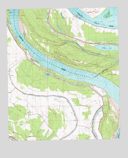
Ashly, LA USGS Topographic Map
Click on map above to begin viewing in our Map Viewer.

This topographic map contains these locations and features:
Feature Name Type Latitude Longitude GNIS ID View Map
Ashley LandingLocaleN32.4357°W91.0632°549204View Map
AshlyPopulated PlaceN32.4415°W91.1232°542939View Map
BarnesPopulated PlaceN32.3793°W91.1232°553349View Map
Bell IslandSwampN32.4926°W91.0115°532916View Map
Bethlehem Church (historical)ChurchN32.4313°W91.0312°549205View Map
Boney LandingLocaleN32.3957°W91.0182°549206View Map
Cabin Teele CrevasseLakeN32.4366°W91.0808°553849View Map
Cabin Teele LandingLocaleN32.4318°W91.0501°549208View Map
Cabin Teele Plantation (historical)LocaleN32.4335°W91.0440°549209View Map
Cattail Lake (historical)LakeN32.3954°W91.0798°549214View Map
Dalkeith Lake (historical)LakeN32.4251°W91.1029°549217View Map
Dalkeith PlantationLocaleN32.4151°W91.1007°549218View Map
Devel John Lake (historical)LakeN32.3971°W91.0751°1631067View Map
Duck Port (historical)Populated PlaceN32.3924°W91.0140°549223View Map
Duckport LandingLocaleN32.3899°W91.0196°549224View Map
Duckport Plantation (historical)LocaleN32.3946°W91.0182°549225View Map
Eagle LakeLakeN32.4994°W91.0061°554311View Map
Forest Home ChuteGutN32.4590°W91.0376°670094View Map
Forest Home Landing (historical)LocaleN32.4371°W91.0246°686327View Map
Forest Home Plantation (historical)LocaleN32.4432°W91.0223°686328View Map
Forest Home TowheadAreaN32.4521°W91.0490°670095View Map
Glen Mary CemeteryCemeteryN32.4120°W91.0735°535247View Map
Glen May PlantationLocaleN32.4176°W91.0729°549228View Map
Grassy LakeLakeN32.4929°W91.0625°670602View Map
Grassy Lake (historical)LakeN32.3793°W91.1079°549504View Map
Halpino LakeLakeN32.4617°W91.0115°670848View Map
Hermean PlantationLocaleN32.4246°W91.1193°549230View Map
Horseshoe Lake (historical)LakeN32.4129°W91.0409°549232View Map
Hughes Store (historical)LocaleN32.4224°W91.1107°549233View Map
Huon PlantationLocaleN32.3863°W91.0515°549234View Map
Huon Store (historical)LocaleN32.3888°W91.0479°549235View Map
Jerusalem ChurchChurchN32.4371°W91.1223°536033View Map
John Palm LakeSwampN32.4326°W91.0973°549237View Map
Marshall CutoffChannelN32.4243°W91.0115°549243View Map
Meredith Plantation (historical)LocaleN32.4751°W91.0168°686351View Map
Mill BayouGutN32.3782°W91.1037°537093View Map
Mill Lake (historical)LakeN32.3915°W91.0815°549247View Map
Millikens BendBendN32.4801°W91.1148°549507View Map
Millikens Bend (historical)Populated PlaceN32.4557°W91.1048°549245View Map
Millikin Bend RevetmentLeveeN32.4418°W91.0765°549246View Map
Morancy LandingLocaleN32.4724°W91.1129°549248View Map
Mount Pisgah Church (historical)ChurchN32.4746°W91.1193°549251View Map
Mount Zion ChurchChurchN32.3938°W91.0493°537448View Map
Nebraska Plantation (historical)LocaleN32.3815°W91.0121°549255View Map
New Mount Zion ChurchChurchN32.4018°W91.1029°537611View Map
Omega LandingLocaleN32.4968°W91.1223°549256View Map
Parish Governing Authority District 1CivilN32.3850°W91.0748°1929746View Map
PeelersPopulated PlaceN32.4915°W91.0468°675573View Map
Pervis LakeLakeN32.4819°W91.0660°675640View Map
Peters Rock ChurchChurchN32.4190°W91.1009°538086View Map
Pine Grove Lake (historical)LakeN32.3968°W91.0376°549258View Map
Saint John ChurchChurchN32.4160°W91.0665°538882View Map
Saint Pauls Church (historical)ChurchN32.3974°W91.0237°549264View Map
Sparta LandingLocaleN32.4015°W91.0112°549267View Map
Sparta PlantationLocaleN32.4188°W91.0287°1631083View Map
Sunflower Lake (historical)LakeN32.4363°W91.0896°549268View Map

Note: Coordinates in the location and feature list above are referenced to NAD83 datum.


Copyright (C) 2008-2024 Ryan Niemi / Sunset Dynamics ... All Rights Reserved