TopoQuest Logo
Do you find TopoQuest useful?
Help keep TopoQuest running and adding new maps/features by donating!
Bitcoin:  19c7KJd3qBynnjoSw5npx9KScwjBe4ifkT
Litecoin:  LXs6TkuXGGXo1vDsWCkWVdjQX94eUKd6ui
Home View Maps Find Maps Find Places Resources & Links


Ghio, North Carolina Topographic Map

USGS Map Title: Ghio, NC
USGS Map MRC: 34079G6
DRG (GeoTIFF) Download: o34079g6.tif


Neighboring USGS Topographic Map Quads:


  Rockingham, NC  
34079H7
 

  Hamlet, NC  
34079H6
 

  Marston, NC  
34079H5
 

  Diggs, NC  
34079G7
 

  Ghio, NC  
34079G6
 

  Gibson, NC  
34079G5
 

  Wallace, SC  
34079F7
 

  Bennettsville North, SC  
34079F6
 

  McColl, SC  
34079F5


Map MRC Location:

N35°
W80°
N35°
W79°
H8 H7 H6 H5 H4 H3 H2 H1
G8 G7 G6 G5 G4 G3 G2 G1
F8 F7 F6 F5 F4 F3 F2 F1
E8 E7 E6 E5 E4 E3 E2 E1
D8 D7 D6 D5 D4 D3 D2 D1
C8 C7 C6 C5 C4 C3 C2 C1
B8 B7 B6 B5 B4 B3 B2 B1
A8 A7 A6 A5 A4 A3 A2 A1
N34°
W80°
N34°
W79°

Ghio, NC USGS 1:24K Topographic Map Preview:
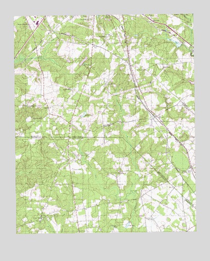
Ghio, NC USGS Topographic Map
Click on map above to begin viewing in our Map Viewer.

This topographic map contains these locations and features:
Feature Name Type Latitude Longitude GNIS ID View Map
Aaron Temple Methodist ChurchChurchN34.7588°W79.7320°1232651View Map
Aarons TempleLocaleN34.7585°W79.7320°1244838View Map
Barrington CemeteryCemeteryN34.8168°W79.6692°980587View Map
Battley PondReservoirN34.8676°W79.7489°998173View Map
Battley Pond DamDamN34.8668°W79.7481°998174View Map
Breedens Chapel (historical)ChurchN34.7843°W79.6853°1232675View Map
Brigman CemeteryCemeteryN34.7535°W79.6923°1220963View Map
Camp Pee Dee Pond Number TwoReservoirN34.7525°W79.7477°1240276View Map
Camp Pee Dee Pond Number Two Dam D-3435DamN34.7518°W79.7481°1240275View Map
English CemeteryCemeteryN34.7579°W79.6589°1222289View Map
Ghio Scholl StationPopulated PlaceN34.8168°W79.6509°985650View Map
Green ChapelChurchN34.8446°W79.6462°986050View Map
Green Chapel CemeteryCemeteryN34.8449°W79.6464°1731483View Map
Green PondPopulated PlaceN34.7846°W79.6326°986080View Map
Green Pond CemeteryCemeteryN34.7843°W79.6339°1731494View Map
Green Pond ChurchChurchN34.7846°W79.6314°1731495View Map
Honeysucker PondReservoirN34.7835°W79.6631°1240262View Map
Honeysucker Pond Dam D-2959DamN34.7835°W79.6631°1240261View Map
James PondReservoirN34.8182°W79.7017°998136View Map
James Pond DamDamN34.8167°W79.7037°998137View Map
Kingsbury CreekStreamN34.8721°W79.6273°988010View Map
Krinshaw PondReservoirN34.8165°W79.7039°988063View Map
Lightwood Knot CreekStreamN34.7729°W79.6687°988478View Map
Livingston ChapelChurchN34.8138°W79.6484°1731498View Map
Moore PondReservoirN34.7539°W79.6826°1224638View Map
Morrison Grove CemeteryCemeteryN34.8699°W79.7403°1731484View Map
Morrison Grove ChurchChurchN34.8702°W79.7398°1731485View Map
Morrison Grove SchoolSchoolN34.8704°W79.7401°990271View Map
Mount Moriah CemeteryCemeteryN34.8432°W79.6589°1731486View Map
Mount Moriah ChurchChurchN34.8429°W79.6587°990434View Map
Nebo CemeteryCemeteryN34.8215°W79.7270°1731487View Map
Nebo ChurchChurchN34.8215°W79.7267°990889View Map
Oak Ridge CemeteryCemeteryN34.8626°W79.6837°991435View Map
Oak Ridge ChurchChurchN34.8627°W79.6856°991437View Map
Oak Ridge SchoolSchoolN34.7843°W79.6781°1225130View Map
Pate Lake DamDamN34.8577°W79.6334°998166View Map
Pate PondReservoirN34.8587°W79.6372°991928View Map
Pates Lake Number TwoReservoirN34.8535°W79.6381°998161View Map
Pates Lake Number Two DamDamN34.8535°W79.6381°998160View Map
Peele CemeteryCemeteryN34.7757°W79.6401°1225345View Map
Pineville SchoolSchoolN34.7577°W79.7328°1225483View Map
Pineville SchoolSchoolN34.7865°W79.7045°1225484View Map
Prevatts ChapelChurchN34.7924°W79.7123°1250239View Map
Quick CemeteryCemeteryN34.7777°W79.6784°1225720View Map
Quicks Mill (historical)LocaleN34.7946°W79.7034°1232782View Map
Roscoe PondReservoirN34.8471°W79.7012°993680View Map
Scholl CemeteryCemeteryN34.8115°W79.6551°994412View Map
Seal CemeteryCemeteryN34.8460°W79.6709°994457View Map
Smith CemeteryCemeteryN34.8332°W79.6942°994943View Map
Spring Hill ChurchChurchN34.8357°W79.6864°995344View Map
Steen TownPopulated PlaceN34.8713°W79.6531°1022786View Map
Tabernacle CemeteryCemeteryN34.8040°W79.6467°995805View Map
Tabernacle ChurchChurchN34.8157°W79.6489°1731506View Map
Terry PondReservoirN34.8330°W79.7114°995947View Map
Usher PondReservoirN34.7544°W79.6724°1227327View Map
Waymon ChapelChurchN34.8163°W79.7370°996887View Map
Waymon Chapel CemeteryCemeteryN34.8163°W79.7373°1731488View Map
Waymon Chapel SchoolSchoolN34.8238°W79.7423°996888View Map
Wilva Fruit FarmLocaleN34.8260°W79.7062°1731489View Map

Note: Coordinates in the location and feature list above are referenced to NAD83 datum.


Copyright (C) 2008-2024 Ryan Niemi / Sunset Dynamics ... All Rights Reserved