TopoQuest Logo
Do you find TopoQuest useful?
Help keep TopoQuest running and adding new maps/features by donating!
Bitcoin:  19c7KJd3qBynnjoSw5npx9KScwjBe4ifkT
Litecoin:  LXs6TkuXGGXo1vDsWCkWVdjQX94eUKd6ui
Home View Maps Find Maps Find Places Resources & Links


Gold Point, Nevada Topographic Map

USGS Map Title: Gold Point, NV
USGS Map MRC: 37117C3
DRG (GeoTIFF) Download: o37117c3.tif


Neighboring USGS Topographic Map Quads:


  Lida, NV  
37117D4
 

  Mount Jackson, NV  
37117D3
 

  Stonewall Pass, NV  
37117D2
 

  Gold Point SW, NV  
37117C4
 

  Gold Point, NV  
37117C3
 

  Scottys Junction SW, NV  
37117C2
 

  West of Gold Mountain, NV  
37117B4
 

  Gold Mountain, NV  
37117B3
 

  Bonnie Claire NW, NV  
37117B2


Map MRC Location:

N38°
W118°
N38°
W117°
H8 H7 H6 H5 H4 H3 H2 H1
G8 G7 G6 G5 G4 G3 G2 G1
F8 F7 F6 F5 F4 F3 F2 F1
E8 E7 E6 E5 E4 E3 E2 E1
D8 D7 D6 D5 D4 D3 D2 D1
C8 C7 C6 C5 C4 C3 C2 C1
B8 B7 B6 B5 B4 B3 B2 B1
A8 A7 A6 A5 A4 A3 A2 A1
N37°
W118°
N37°
W117°

Gold Point, NV USGS 1:24K Topographic Map Preview:
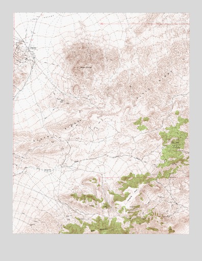
Gold Point, NV USGS Topographic Map
Click on map above to begin viewing in our Map Viewer.

This topographic map contains these locations and features:
Feature Name Type Latitude Longitude GNIS ID View Map
Alberto MineMineN37.2819°W117.2645°838405View Map
Big Blossom MineMineN37.2602°W117.2648°838713View Map
Causer Well CorralLocaleN37.2599°W117.3381°839361View Map
Checkmate MineMineN37.3097°W117.3165°853402View Map
Courbet MineMineN37.2585°W117.2845°839789View Map
Dunfee ShaftMineN37.3252°W117.3406°840218View Map
Empress MineMineN37.2647°W117.3087°840366View Map
Frenchman WellWellN37.2549°W117.3637°840574View Map
Gold MountainSummitN37.2522°W117.3056°845305View Map
Gold Mountain MineMineN37.3280°W117.3229°853401View Map
Gold Mountain PeakSummitN37.2522°W117.3056°851664View Map
Gold PointPopulated PlaceN37.3547°W117.3651°854466View Map
Gold Point Post Office (historical)Post OfficeN37.3547°W117.3651°864784View Map
Gold Point Volunteer Fire DepartmentBuildingN37.3539°W117.3650°2581423View Map
Great Western MineMineN37.3483°W117.3673°853399View Map
Hanging MesaSummitN37.2760°W117.2890°840887View Map
Hidden Treasure MineMineN37.2913°W117.2676°854794View Map
Huson MineMineN37.3035°W117.2531°853396View Map
Lime PointCliffN37.3677°W117.3262°851688View Map
Mount DunfeeSummitN37.3430°W117.3287°840219View Map
Ohio MineMineN37.3530°W117.3648°853398View Map
Old CampPopulated PlaceN37.2583°W117.3248°845928View Map
Oriental MineMineN37.2705°W117.2695°842638View Map
Oriental Post OfficePost OfficeN37.2580°W117.3234°864322View Map
Redemption MineMineN37.3424°W117.3748°853400View Map
Silver Chain MineMineN37.2922°W117.3659°851668View Map
Slate RidgeRidgeN37.3318°W117.2782°843752View Map
TokopPopulated PlaceN37.3016°W117.2612°856152View Map
Tokop Mining DistrictCivilN37.2560°W117.2817°856591View Map
Wonder MineMineN37.2760°W117.3131°853404View Map
Wylie Green MineMineN37.2588°W117.2642°853397View Map

Note: Coordinates in the location and feature list above are referenced to NAD83 datum.


Copyright (C) 2008-2025 Ryan Niemi / Sunset Dynamics ... All Rights Reserved