TopoQuest Logo
Do you find TopoQuest useful?
Help keep TopoQuest running and adding new maps/features by donating!
Bitcoin:  19c7KJd3qBynnjoSw5npx9KScwjBe4ifkT
Litecoin:  LXs6TkuXGGXo1vDsWCkWVdjQX94eUKd6ui
Home View Maps Find Maps Find Places Resources & Links


Goliad, Texas Topographic Map

USGS Map Title: Goliad, TX
USGS Map MRC: 28097F4
DRG (GeoTIFF) Download: o28097f4.tif


Neighboring USGS Topographic Map Quads:


  Runge SE, TX  
28097G5
 

  Weesatche, TX  
28097G4
 

  Ander, TX  
28097G3
 

  Charco, TX  
28097F5
 

  Goliad, TX  
28097F4
 

  Hensley Lake, TX  
28097F3
 

  Berclair, TX  
28097E5
 

  Melo, TX  
28097E4
 

  Live Oak Lake, TX  
28097E3


Map MRC Location:

N29°
W98°
N29°
W97°
H8 H7 H6 H5 H4 H3 H2 H1
G8 G7 G6 G5 G4 G3 G2 G1
F8 F7 F6 F5 F4 F3 F2 F1
E8 E7 E6 E5 E4 E3 E2 E1
D8 D7 D6 D5 D4 D3 D2 D1
C8 C7 C6 C5 C4 C3 C2 C1
B8 B7 B6 B5 B4 B3 B2 B1
A8 A7 A6 A5 A4 A3 A2 A1
N28°
W98°
N28°
W97°

Goliad, TX USGS 1:24K Topographic Map Preview:
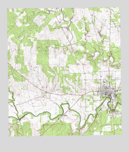
Goliad, TX USGS Topographic Map
Click on map above to begin viewing in our Map Viewer.

This topographic map contains these locations and features:
Feature Name Type Latitude Longitude GNIS ID View Map
Cabeza CreekStreamN28.6419°W97.4881°1377528View Map
Captain Barton Peck HouseBuildingN28.6667°W97.4017°2031457View Map
Charles H and Catherine B Baker HouseBuildingN28.6611°W97.3942°2031413View Map
City of GoliadCivilN28.6709°W97.3917°2410615View Map
Doctor LW and Martha ES Chilton HouseBuildingN28.6703°W97.3942°2031324View Map
Dry CreekStreamN28.7478°W97.4539°1356309View Map
Farley WindmillLocaleN28.6397°W97.4550°1357235View Map
Flores CemeteryCemeteryN28.6447°W97.3878°1357496View Map
Glendale CemeteryCemeteryN28.6808°W97.3811°1358056View Map
GoliadPopulated PlaceN28.6683°W97.3883°1358133View Map
Goliad City HallBuildingN28.6657°W97.3937°2753693View Map
Goliad CountyCivilN28.6571°W97.4265°1383873View Map
Goliad County Courthouse Historic DistrictLocaleN28.6675°W97.3897°2032109View Map
Goliad County Emergency Medical ServicesBuildingN28.6662°W97.3957°2656065View Map
Goliad County FairgoundParkN28.6594°W97.3836°2028259View Map
Goliad County JailBuildingN28.6652°W97.3847°2738763View Map
Goliad County Sheriff's OfficeBuildingN28.6653°W97.3847°2335017View Map
Goliad Elementary SchoolSchoolN28.6709°W97.3932°2005568View Map
Goliad High SchoolSchoolN28.6770°W97.3944°2434568View Map
Goliad North DivisionCivilN28.7198°W97.4199°1938788View Map
Goliad Post OfficePost OfficeN28.6657°W97.3937°2731595View Map
Goliad State ParkParkN28.6555°W97.3850°1358135View Map
Goliad State Park TrailTrailN28.6555°W97.3850°2032779View Map
Goliad Volunteer Fire DepartmentBuildingN28.6664°W97.3936°2334251View Map
Jessie W Stoddard HouseBuildingN28.6650°W97.3883°2030925View Map
Lott CemeteryCemeteryN28.6675°W97.4194°1361860View Map
Market House MuseumBuildingN28.6569°W97.4264°2014120View Map
Martinez CreekStreamN28.6336°W97.4222°1362237View Map
Matt WindmillLocaleN28.6367°W97.4117°1362288View Map
Mission Espiritu SantoChurchN28.6572°W97.3867°1362969View Map
Mission Nuestra Senora del RosarioLocaleN28.6455°W97.4397°1362972View Map
Mount Moriah Baptist ChurchChurchN28.6717°W97.3939°2018624View Map
Mud CreekStreamN28.7150°W97.4300°1375046View Map
Old Market House MuseumBuildingN28.6669°W97.3908°2032339View Map
Peters CreekStreamN28.7461°W97.4397°1365107View Map
Placedo WindmillLocaleN28.6344°W97.4355°1365366View Map
Post Oak HollowValleyN28.7289°W97.4324°1375540View Map
Presidio La BahiaLocaleN28.6480°W97.3819°1365757View Map
Presidio la Bahia MuseumBuildingN28.6569°W97.4264°2014121View Map
Presidio Nuestra Senora de Loreto de la BahiaLocaleN28.6480°W97.3789°2032053View Map
River WindmillLocaleN28.6486°W97.4330°1366523View Map
Rubio Cristo Rey CemeteryCemeteryN28.6478°W97.3817°2095258View Map
Whaley HollowValleyN28.7384°W97.4310°1371313View Map
Wisbey CemeteryCemeteryN28.6597°W97.4130°1371819View Map
Zion Hill ChurchChurchN28.6622°W97.4069°1372095View Map

Note: Coordinates in the location and feature list above are referenced to NAD83 datum.


Copyright (C) 2008-2025 Ryan Niemi / Sunset Dynamics ... All Rights Reserved