TopoQuest Logo
Do you find TopoQuest useful?
Help keep TopoQuest running and adding new maps/features by donating!
Bitcoin:  19c7KJd3qBynnjoSw5npx9KScwjBe4ifkT
Litecoin:  LXs6TkuXGGXo1vDsWCkWVdjQX94eUKd6ui
Home View Maps Find Maps Find Places Resources & Links


Good Point, Colorado Topographic Map

USGS Map Title: Good Point, CO
USGS Map MRC: 38108F3
DRG (GeoTIFF) Download: o38108f3.tif


Neighboring USGS Topographic Map Quads:


  Triangle Mesa, CO  
38108G4
 

  Dominguez, CO  
38108G3
 

  Point Creek, CO  
38108G2
 

  Escalante Forks, CO  
38108F4
 

  Good Point, CO  
38108F3
 

  Roubideau, CO  
38108F2
 

  Kelso Point, CO  
38108E4
 

  Cottonwood Basin, CO  
38108E3
 

  Camel Back, CO  
38108E2


Map MRC Location:

N39°
W109°
N39°
W108°
H8 H7 H6 H5 H4 H3 H2 H1
G8 G7 G6 G5 G4 G3 G2 G1
F8 F7 F6 F5 F4 F3 F2 F1
E8 E7 E6 E5 E4 E3 E2 E1
D8 D7 D6 D5 D4 D3 D2 D1
C8 C7 C6 C5 C4 C3 C2 C1
B8 B7 B6 B5 B4 B3 B2 B1
A8 A7 A6 A5 A4 A3 A2 A1
N38°
W109°
N38°
W108°

Good Point, CO USGS 1:24K Topographic Map Preview:
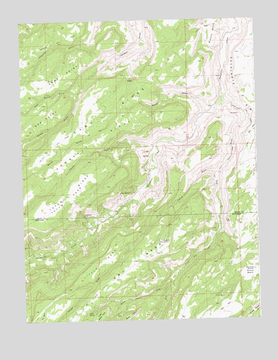
Good Point, CO USGS Topographic Map
Click on map above to begin viewing in our Map Viewer.

This topographic map contains these locations and features:
Feature Name Type Latitude Longitude GNIS ID View Map
Alum SpringSpringN38.6278°W108.3415°185490View Map
Black PointCliffN38.6283°W108.3167°203096View Map
Black Point DrawValleyN38.6434°W108.2939°185488View Map
Boyce GulchValleyN38.7131°W108.2726°185476View Map
Camp RidgeRidgeN38.7105°W108.3317°203089View Map
Caps SpringSpringN38.6783°W108.3184°185493View Map
Cottonwood SpringSpringN38.6690°W108.3431°185492View Map
Dry Fork Escalante CreekStreamN38.7158°W108.2665°185489View Map
Dry Mesa Reservoir Number 2ReservoirN38.6577°W108.2976°185491View Map
Escalante RimCliffN38.7194°W108.2601°203067View Map
Gunnison TrailTrailN38.7405°W108.3587°203095View Map
KeyholePopulated PlaceN38.6930°W108.3090°185481View Map
Little Black PointCliffN38.6294°W108.3326°203097View Map
Little MesaSummitN38.6383°W108.3520°185487View Map
McCarthy TrailTrailN38.6917°W108.3665°203091View Map
Porter SpringSpringN38.6344°W108.2741°185485View Map
Sowbelly RidgeRidgeN38.6936°W108.3481°203088View Map
Stone BasinBasinN38.6436°W108.2551°185484View Map
Stone Basin ReservoirReservoirN38.6456°W108.2526°185483View Map
Tatum DrawValleyN38.6862°W108.2708°185480View Map
Tatum GulchValleyN38.6976°W108.3045°185475View Map
Tatum ParkFlatN38.6761°W108.3509°185482View Map
Tatum RidgeRidgeN38.6769°W108.3523°203090View Map
West Palmer GulchValleyN38.7204°W108.3434°185479View Map

Note: Coordinates in the location and feature list above are referenced to NAD83 datum.


Copyright (C) 2008-2025 Ryan Niemi / Sunset Dynamics ... All Rights Reserved