TopoQuest Logo
Do you find TopoQuest useful?
Help keep TopoQuest running and adding new maps/features by donating!
Bitcoin:  19c7KJd3qBynnjoSw5npx9KScwjBe4ifkT
Litecoin:  LXs6TkuXGGXo1vDsWCkWVdjQX94eUKd6ui
Home View Maps Find Maps Find Places Resources & Links


Gordon, Louisiana Topographic Map

USGS Map Title: Gordon, LA
USGS Map MRC: 30093D3
DRG (GeoTIFF) Download: o30093d3.tif


Neighboring USGS Topographic Map Quads:


  Oretta, LA  
30093E4
 

  Kernan, LA  
30093E3
 

  Longville, LA  
30093E2
 

  DeQuincy, LA  
30093D4
 

  Gordon, LA  
30093D3
 

  Gaytine, LA  
30093D2
 

  Brimstone, LA  
30093C4
 

  Buhler, LA  
30093C3
 

  Moss Bluff, LA  
30093C2


Map MRC Location:

N31°
W94°
N31°
W93°
H8 H7 H6 H5 H4 H3 H2 H1
G8 G7 G6 G5 G4 G3 G2 G1
F8 F7 F6 F5 F4 F3 F2 F1
E8 E7 E6 E5 E4 E3 E2 E1
D8 D7 D6 D5 D4 D3 D2 D1
C8 C7 C6 C5 C4 C3 C2 C1
B8 B7 B6 B5 B4 B3 B2 B1
A8 A7 A6 A5 A4 A3 A2 A1
N30°
W94°
N30°
W93°

Gordon, LA USGS 1:24K Topographic Map Preview:
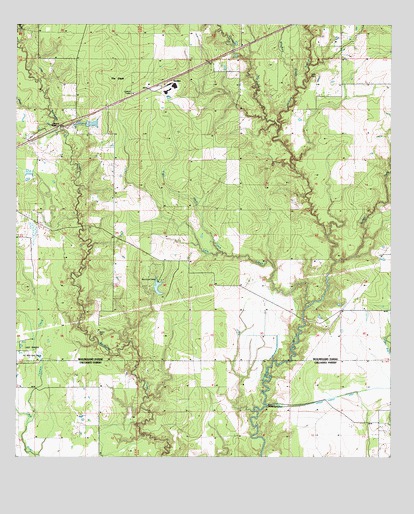
Gordon, LA USGS Topographic Map
Click on map above to begin viewing in our Map Viewer.

This topographic map contains these locations and features:
Feature Name Type Latitude Longitude GNIS ID View Map
Abbie Joe (historical)Populated PlaceN30.4919°W93.3032°544790View Map
Alston CemeteryCemeteryN30.4108°W93.3477°532146View Map
Beauregard Volunteer Fire Protection District 2 Gordon StationBuildingN30.4801°W93.3356°2691858View Map
Beckwith ChurchChurchN30.4744°W93.3493°532869View Map
Calvary Pentecostal ChurchChurchN30.4941°W93.2998°2601428View Map
Camp EdgewoodLocaleN30.4258°W93.3277°544789View Map
Cowpen CreekStreamN30.4694°W93.2877°554111View Map
Cypress CreekStreamN30.3846°W93.3707°554167View Map
East Perkins Oil and Gas FieldOilfieldN30.4058°W93.3690°554329View Map
Evart (historical)Populated PlaceN30.4938°W93.3002°1630144View Map
GekopPopulated PlaceN30.4727°W93.3552°544787View Map
Gillie CemeteryCemeteryN30.4846°W93.2752°535225View Map
GordonPopulated PlaceN30.4844°W93.3232°543248View Map
Gordon Lookout TowerTowerN30.4799°W93.3366°544788View Map
Jackson GullyStreamN30.4313°W93.2682°554857View Map
Little CreekStreamN30.4180°W93.2779°536524View Map
Louisiana Noname 82 DamDamN30.4235°W93.3285°556944View Map
Mayhaw GladeStreamN30.4816°W93.2815°536952View Map
Parish Governing Authority District 4ACivilN30.4902°W93.2550°1930050View Map
Pilgrims Rest Baptist ChurchChurchN30.4499°W93.3418°555646View Map
The GladeFlatN30.4838°W93.3410°539848View Map
Tiger Glade CreekStreamN30.4344°W93.3065°539927View Map

Note: Coordinates in the location and feature list above are referenced to NAD83 datum.


Copyright (C) 2008-2024 Ryan Niemi / Sunset Dynamics ... All Rights Reserved