TopoQuest Logo
Do you find TopoQuest useful?
Help keep TopoQuest running and adding new maps/features by donating!
Bitcoin:  19c7KJd3qBynnjoSw5npx9KScwjBe4ifkT
Litecoin:  LXs6TkuXGGXo1vDsWCkWVdjQX94eUKd6ui
Home View Maps Find Maps Find Places Resources & Links


Gordon, Texas Topographic Map

USGS Map Title: Gordon, TX
USGS Map MRC: 32098E3
DRG (GeoTIFF) Download: o32098e3.tif


Neighboring USGS Topographic Map Quads:


  Metcalf Gap, TX  
32098F4
 

  Lone Camp, TX  
32098F3
 

  Brazos West, TX  
32098F2
 

  Strawn East, TX  
32098E4
 

  Gordon, TX  
32098E3
 

  Santo, TX  
32098E2
 

  Reddy Mountain, TX  
32098D4
 

  Turkey Creek, TX  
32098D3
 

  Morgan Mill, TX  
32098D2


Map MRC Location:

N33°
W99°
N33°
W98°
H8 H7 H6 H5 H4 H3 H2 H1
G8 G7 G6 G5 G4 G3 G2 G1
F8 F7 F6 F5 F4 F3 F2 F1
E8 E7 E6 E5 E4 E3 E2 E1
D8 D7 D6 D5 D4 D3 D2 D1
C8 C7 C6 C5 C4 C3 C2 C1
B8 B7 B6 B5 B4 B3 B2 B1
A8 A7 A6 A5 A4 A3 A2 A1
N32°
W99°
N32°
W98°

Gordon, TX USGS 1:24K Topographic Map Preview:
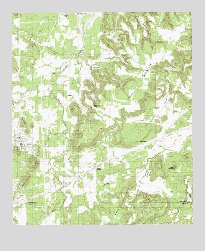
Gordon, TX USGS Topographic Map
Click on map above to begin viewing in our Map Viewer.

This topographic map contains these locations and features:
Feature Name Type Latitude Longitude GNIS ID View Map
Barton CreekStreamN32.5887°W98.3434°1372409View Map
Blue CemeteryCemeteryN32.5271°W98.2837°1330897View Map
Blue FlatFlatN32.5207°W98.2720°1330900View Map
Blue Flat CemeteryCemeteryN32.5237°W98.2812°1330901View Map
Bridges BranchStreamN32.5332°W98.2839°1331259View Map
Brierton CemeteryCemeteryN32.5618°W98.2517°1331267View Map
Carter BranchStreamN32.6010°W98.3339°1332214View Map
City of GordonCivilN32.5455°W98.3672°2410623View Map
Clayton MountainSummitN32.5718°W98.2995°1332918View Map
Clayton SpringSpringN32.5690°W98.3163°1332922View Map
CoalvillePopulated PlaceN32.5757°W98.3323°1378137View Map
Doty CemeteryCemeteryN32.5299°W98.3403°1334516View Map
Duncan HollowValleyN32.5187°W98.2836°1373501View Map
Gibson CemeteryCemeteryN32.5225°W98.3319°1336512View Map
Gibson CreekStreamN32.5718°W98.3723°1336513View Map
GordonPopulated PlaceN32.5485°W98.3692°1336733View Map
Gordon City HallBuildingN32.5486°W98.3694°2551925View Map
Gordon City HallBuildingN32.5482°W98.3693°2750493View Map
Gordon JunctionPopulated PlaceN32.5346°W98.3181°1378370View Map
Gordon Post OfficePost OfficeN32.5474°W98.3693°2732246View Map
Gordon Volunteer Fire Department Station 1BuildingN32.5495°W98.3694°2551214View Map
Gordon Volunteer Fire Department Station 2BuildingN32.5461°W98.3692°2551209View Map
Henslee Lake Number 1ReservoirN32.5706°W98.3278°1864745View Map
Henslee Lake Number 1 DamDamN32.5718°W98.3287°1864744View Map
Henslee Lake Number 2ReservoirN32.5664°W98.3257°1864751View Map
Henslee Lake Number 2 DamDamN32.5668°W98.3253°1864750View Map
James LakeReservoirN32.5930°W98.3169°1338627View Map
James Lake DamDamN32.5935°W98.3187°1861812View Map
Johnson VaultCemeteryN32.6149°W98.3545°1338817View Map
Judd SwitchLocaleN32.5479°W98.2837°1338911View Map
Little Sunday CreekStreamN32.5512°W98.2509°1340198View Map
Longhorn StadiumParkN32.5526°W98.3692°2027781View Map
Lost CreekStreamN32.5190°W98.2539°1374739View Map
Mitchell MountainSummitN32.5362°W98.3617°1341768View Map
Mount Zion ChurchChurchN32.5282°W98.3298°1342150View Map
New Gordon CemeteryCemeteryN32.5554°W98.3620°1926906View Map
Old Gordon CemeteryCemeteryN32.5624°W98.3609°1926905View Map
Panama CreekStreamN32.5662°W98.2653°1343514View Map
Panama Creek ReservoirReservoirN32.5754°W98.2687°1863512View Map
Panama Creek Reservoir DamDamN32.5735°W98.2687°1863511View Map
Richards Lake Number 1ReservoirN32.5515°W98.2509°1861803View Map
Richards Lake Number 1 DamDamN32.5518°W98.2520°1861802View Map
Russel MountainSummitN32.5335°W98.2625°1345770View Map
Saline CreekStreamN32.5596°W98.2500°1346181View Map
Snider BranchStreamN32.5843°W98.3637°1347333View Map
Swank CemeteryCemeteryN32.5965°W98.3473°1348118View Map
Swank MountainSummitN32.5599°W98.3681°1348119View Map
Tri City Emergency Medical ServicesBuildingN32.5495°W98.3694°2551332View Map
Waddell Ranch Dam Number 3DamN32.6135°W98.2820°1862970View Map
Waddell Ranch Lake Number 1ReservoirN32.6089°W98.3037°1862973View Map
Waddell Ranch Lake Number 1 DamDamN32.6085°W98.3037°1862972View Map
Waddell Ranch Lake Number 3ReservoirN32.6123°W98.2827°1862971View Map
Warters MountainSummitN32.5262°W98.3678°1349506View Map
Watson LakeReservoirN32.5850°W98.3185°1861817View Map
Watson Lake DamDamN32.5851°W98.3187°1861816View Map

Note: Coordinates in the location and feature list above are referenced to NAD83 datum.


Copyright (C) 2008-2025 Ryan Niemi / Sunset Dynamics ... All Rights Reserved