TopoQuest Logo
Do you find TopoQuest useful?
Help keep TopoQuest running and adding new maps/features by donating!
Bitcoin:  19c7KJd3qBynnjoSw5npx9KScwjBe4ifkT
Litecoin:  LXs6TkuXGGXo1vDsWCkWVdjQX94eUKd6ui
Home View Maps Find Maps Find Places Resources & Links


Gove, Kansas Topographic Map

USGS Map Title: Gove, KS
USGS Map MRC: 38100H4
DRG (GeoTIFF) Download: o38100h4.tif


Neighboring USGS Topographic Map Quads:


  Sunny Slope Lake, KS  
39100A5
 

  Grainfield, KS  
39100A4
 

  Park, KS  
39100A3
 

  Orion NE, KS  
38100H5
 

  Gove, KS  
38100H4
 

  Gove NE, KS  
38100H3
 

  Orion SE, KS  
38100G5
 

  Gove SW, KS  
38100G4
 

  Gove SE, KS  
38100G3


Map MRC Location:

N39°
W101°
N39°
W100°
H8 H7 H6 H5 H4 H3 H2 H1
G8 G7 G6 G5 G4 G3 G2 G1
F8 F7 F6 F5 F4 F3 F2 F1
E8 E7 E6 E5 E4 E3 E2 E1
D8 D7 D6 D5 D4 D3 D2 D1
C8 C7 C6 C5 C4 C3 C2 C1
B8 B7 B6 B5 B4 B3 B2 B1
A8 A7 A6 A5 A4 A3 A2 A1
N38°
W101°
N38°
W100°

Gove, KS USGS 1:24K Topographic Map Preview:
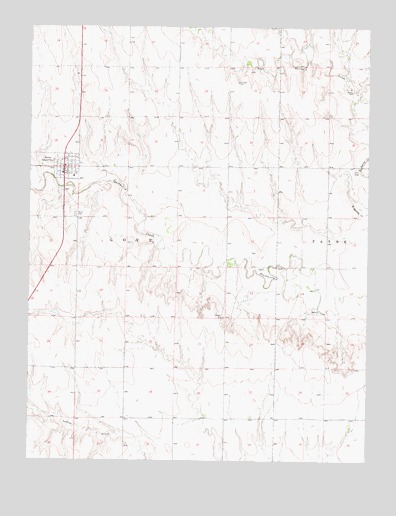
Gove, KS USGS Topographic Map
Click on map above to begin viewing in our Map Viewer.

This topographic map contains these locations and features:
Feature Name Type Latitude Longitude GNIS ID View Map
City of Gove CityCivilN38.9593°W100.4871°2394937View Map
GovePopulated PlaceN38.9578°W100.4887°471381View Map
Gove Bible Baptist ChurchChurchN38.9571°W100.4873°2690849View Map
Gove CemeteryCemeteryN38.9459°W100.4840°471380View Map
Gove City Fire DepartmentBuildingN38.9577°W100.4875°2111367View Map
Gove City LibraryBuildingN38.9569°W100.4873°2694784View Map
Gove CountyCivilN38.9161°W100.4829°485000View Map
Gove County CourthouseBuildingN38.9581°W100.4881°2625128View Map
Gove County Health DepartmentBuildingN38.9568°W100.4843°2695009View Map
Gove County Sheriff's OfficeBuildingN38.9581°W100.4882°2504055View Map
Gove Elementary SchoolSchoolN38.9564°W100.4843°480899View Map
Gove Post OfficePost OfficeN38.9588°W100.4881°2693744View Map
Gove Rural Fire Department.BuildingN38.9577°W100.4875°2111368View Map
Gove Senior CenterBuildingN38.9599°W100.4889°2692741View Map
Gove United Methodist ChurchChurchN38.9598°W100.4874°2689431View Map
Gove Wastewater PlantLocaleN38.9529°W100.4831°2693451View Map

Note: Coordinates in the location and feature list above are referenced to NAD83 datum.


Copyright (C) 2008-2025 Ryan Niemi / Sunset Dynamics ... All Rights Reserved