TopoQuest Logo
Do you find TopoQuest useful?
Help keep TopoQuest running and adding new maps/features by donating!
Bitcoin:  19c7KJd3qBynnjoSw5npx9KScwjBe4ifkT
Litecoin:  LXs6TkuXGGXo1vDsWCkWVdjQX94eUKd6ui
Home View Maps Find Maps Find Places Resources & Links


Grand Bay SW, Alabama Topographic Map

USGS Map Title: Grand Bay SW, AL
USGS Map MRC: 30088C4
DRG (GeoTIFF) Download: o30088c4.tif


Neighboring USGS Topographic Map Quads:


  Pascagoula North, MS  
30088D5
 

  Kreole, MS  
30088D4
 

  Grand Bay, AL  
30088D3
 

  Pascagoula South, MS  
30088C5
 

  Grand Bay SW, AL  
30088C4
 

  Isle aux Herbes, AL  
30088C3
 

  Horn Island East, MS  
30088B5
 

  Petit Bois Island, MS  
30088B4
 

  Petit Bois Pass, AL  
30088B3


Map MRC Location:

N31°
W89°
N31°
W88°
H8 H7 H6 H5 H4 H3 H2 H1
G8 G7 G6 G5 G4 G3 G2 G1
F8 F7 F6 F5 F4 F3 F2 F1
E8 E7 E6 E5 E4 E3 E2 E1
D8 D7 D6 D5 D4 D3 D2 D1
C8 C7 C6 C5 C4 C3 C2 C1
B8 B7 B6 B5 B4 B3 B2 B1
A8 A7 A6 A5 A4 A3 A2 A1
N30°
W89°
N30°
W88°

Grand Bay SW, AL USGS 1:24K Topographic Map Preview:
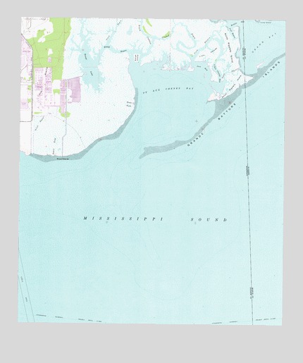
Grand Bay SW, AL USGS Topographic Map
Click on map above to begin viewing in our Map Viewer.

This topographic map contains these locations and features:
Feature Name Type Latitude Longitude GNIS ID View Map
Bangs BayouGutN30.3621°W88.4558°666500View Map
Bangs IslandIslandN30.3594°W88.4456°666501View Map
Bangs LakeLakeN30.3558°W88.4678°666502View Map
Bayou CumbestStreamN30.3566°W88.4445°666604View Map
Bayou RosaStreamN30.3191°W88.4833°666616View Map
Brown BayouStreamN30.3402°W88.4461°667612View Map
Crooked BayouGutN30.3735°W88.4253°668951View Map
Grand BayBayN30.3671°W88.3845°670575View Map
Grande Batture IslandsIslandN30.3580°W88.3822°112851View Map
Grande Batture IslandsIslandN30.3460°W88.3958°670583View Map
Jose BayBayN30.3555°W88.4142°672032View Map
Jose BayouGutN30.3702°W88.4003°672033View Map
L'Isle ChaudeIslandN30.3613°W88.4114°672230View Map
L'Isle Chaude BayGutN30.3602°W88.4061°672231View Map
North BayouStreamN30.3649°W88.4595°674937View Map
North RigoletsGutN30.3638°W88.4133°674959View Map
North Rigolets IslandIslandN30.3616°W88.4008°674960View Map
Point Aux ChenesCapeN30.3185°W88.4803°691600View Map
Point Aux Chenes BayBayN30.3449°W88.4295°676168View Map
Priest BayouStreamN30.3196°W88.4936°676339View Map
South RigoletsGutN30.3538°W88.4011°678010View Map
South Rigolets IslandIslandN30.3513°W88.3920°127138View Map
South Rigolets IslandIslandN30.3494°W88.3986°678011View Map
The PrairieFlatN30.3483°W88.4886°678667View Map

Note: Coordinates in the location and feature list above are referenced to NAD83 datum.


Copyright (C) 2008-2025 Ryan Niemi / Sunset Dynamics ... All Rights Reserved