TopoQuest Logo
Do you find TopoQuest useful?
Help keep TopoQuest running and adding new maps/features by donating!
Bitcoin:  19c7KJd3qBynnjoSw5npx9KScwjBe4ifkT
Litecoin:  LXs6TkuXGGXo1vDsWCkWVdjQX94eUKd6ui
Home View Maps Find Maps Find Places Resources & Links


Grand Coulee Dam, Washington Topographic Map

USGS Map Title: Grand Coulee Dam, WA
USGS Map MRC: 47118H8
DRG (GeoTIFF) Download: o47118h8.tif


Neighboring USGS Topographic Map Quads:


  Sanderson Creek, WA  
48119A1
 

  Belvedere, WA  
48118A8
 

  Keller Butte, WA  
48118A7
 

  Electric City, WA  
47119H1
 

  Grand Coulee Dam, WA  
47118H8
 

  Mica Mountain, WA  
47118H7
 

  Steamboat Rock SE, WA  
47119G1
 

  Jack Woods Butte, WA  
47118G8
 

  Broadax Draw, WA  
47118G7


Map MRC Location:

N48°
W119°
N48°
W118°
H8 H7 H6 H5 H4 H3 H2 H1
G8 G7 G6 G5 G4 G3 G2 G1
F8 F7 F6 F5 F4 F3 F2 F1
E8 E7 E6 E5 E4 E3 E2 E1
D8 D7 D6 D5 D4 D3 D2 D1
C8 C7 C6 C5 C4 C3 C2 C1
B8 B7 B6 B5 B4 B3 B2 B1
A8 A7 A6 A5 A4 A3 A2 A1
N47°
W119°
N47°
W118°

Grand Coulee Dam, WA USGS 1:24K Topographic Map Preview:
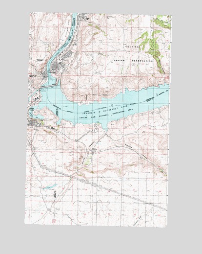
Grand Coulee Dam, WA USGS Topographic Map
Click on map above to begin viewing in our Map Viewer.

This topographic map contains these locations and features:
Feature Name Type Latitude Longitude GNIS ID View Map
Central SchoolSchoolN47.9727°W118.9709°1514517View Map
Cole ParkParkN47.9657°W118.9864°1514520View Map
Columbia Elementary SchoolSchoolN47.9665°W118.9859°1514519View Map
Coulee DamPopulated PlaceN47.9654°W118.9761°1504196View Map
Coulee Dam Community ChurchChurchN47.9666°W118.9735°2609404View Map
Coulee Dam Fire DepartmentBuildingN47.9664°W118.9793°2619392View Map
Coulee Dam Police DepartmentBuildingN47.9636°W118.9888°2722062View Map
Coulee Dam Post OfficePost OfficeN47.9663°W118.9762°2769253View Map
Coulee Dam Seaplane BaseAirportN47.9521°W118.9697°1511815View Map
Crescent BayLakeN47.9381°W118.9923°1513091View Map
Crown Point State ParkParkN47.9713°W118.9861°1513730View Map
Crown Point VistaPopulated PlaceN47.9713°W118.9870°1513094View Map
Douglas ParkParkN47.9635°W118.9842°1514526View Map
East HeightsPopulated PlaceN47.9324°W118.9817°1511883View Map
Eden HarborBayN47.9360°W118.9717°1509964View Map
Elmer CityPopulated PlaceN47.9979°W118.9545°1512189View Map
Elmer City Post OfficePost OfficeN47.9986°W118.9536°2769174View Map
Fiddle CreekStreamN47.9660°W118.9839°1504867View Map
Gibbs BayBayN47.9349°W118.9584°1531791View Map
Grand Coulee DamDamN47.9566°W118.9777°1513929View Map
Greene Memorial FieldParkN47.9713°W118.9731°1514195View Map
Hells CanyonValleyN47.9607°W118.8803°1505455View Map
KEYG-AM (Grand Coulee)TowerN47.8827°W118.9734°1534494View Map
KEYG-AM (Grand Coulee)TowerN47.8827°W118.9734°1534496View Map
KEYG-FM (Grand Coulee)TowerN47.8827°W118.9734°1534524View Map
Lake Roosevelt High SchoolSchoolN47.9702°W118.9729°1514254View Map
Lake Roosevelt National Recreation Area HeadquartersBuildingN47.9696°W118.9678°1514518View Map
Lone PinePopulated PlaceN47.9824°W118.9631°1512399View Map
Long LakeLakeN47.8967°W118.9783°1506290View Map
Mason CityPopulated PlaceN47.9665°W118.9678°1511663View Map
Mason City (historical)Populated PlaceN47.9513°W118.9678°1514921View Map
Mead ParkParkN47.9660°W118.9759°1514283View Map
Okanogan County Fire District 2BuildingN47.9979°W118.9532°2643913View Map
Pine Tree PointCapeN47.9471°W118.9353°1509965View Map
Rattlesnake CanyonValleyN47.9432°W118.9906°1509966View Map
Sand HillSummitN47.9710°W118.9672°1512639View Map
Seaton CanyonValleyN47.9288°W118.9309°1510411View Map
Spring CanyonValleyN47.9302°W118.9311°1508620View Map
The Church of Jesus Christ of Latter Day SaintsChurchN47.9698°W118.9738°2609405View Map
Town of Coulee DamCivilN47.9687°W118.9761°2413249View Map
Town of Elmer CityCivilN47.9998°W118.9530°2412478View Map
Washington FlatsFlatN47.9896°W118.9686°1509301View Map

Note: Coordinates in the location and feature list above are referenced to NAD83 datum.


Copyright (C) 2008-2024 Ryan Niemi / Sunset Dynamics ... All Rights Reserved