TopoQuest Logo
Do you find TopoQuest useful?
Help keep TopoQuest running and adding new maps/features by donating!
Bitcoin:  19c7KJd3qBynnjoSw5npx9KScwjBe4ifkT
Litecoin:  LXs6TkuXGGXo1vDsWCkWVdjQX94eUKd6ui
Home View Maps Find Maps Find Places Resources & Links


Grand Detour, Illinois Topographic Map

USGS Map Title: Grand Detour, IL
USGS Map MRC: 41089H4
DRG (GeoTIFF) Download: o41089h4.tif


Neighboring USGS Topographic Map Quads:


  Forreston South, IL  
42089A5
 

  Mount Morris, IL  
42089A4
 

  Oregon, IL  
42089A3
 

  Polo, IL  
41089H5
 

  Grand Detour, IL  
41089H4
 

  Daysville, IL  
41089H3
 

  Dixon West, IL  
41089G5
 

  Dixon East, IL  
41089G4
 

  Franklin Grove, IL  
41089G3


Map MRC Location:

N42°
W90°
N42°
W89°
H8 H7 H6 H5 H4 H3 H2 H1
G8 G7 G6 G5 G4 G3 G2 G1
F8 F7 F6 F5 F4 F3 F2 F1
E8 E7 E6 E5 E4 E3 E2 E1
D8 D7 D6 D5 D4 D3 D2 D1
C8 C7 C6 C5 C4 C3 C2 C1
B8 B7 B6 B5 B4 B3 B2 B1
A8 A7 A6 A5 A4 A3 A2 A1
N41°
W90°
N41°
W89°

Grand Detour, IL USGS 1:24K Topographic Map Preview:
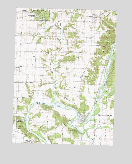
Grand Detour, IL USGS Topographic Map
Click on map above to begin viewing in our Map Viewer.

This topographic map contains these locations and features:
Feature Name Type Latitude Longitude GNIS ID View Map
Anterior School (historical)SchoolN41.9459°W89.4693°403538View Map
Bend School (historical)SchoolN41.8925°W89.4412°404165View Map
Blackhawk CampLocaleN41.9545°W89.4293°1706067View Map
Brethren CemeteryCemeteryN41.9539°W89.4754°1808187View Map
Camp RalstonLocaleN41.9220°W89.3815°1706071View Map
Cedar Ridge CampgroundLocaleN41.9936°W89.4759°1808199View Map
Center School (historical)SchoolN41.9670°W89.4576°405836View Map
Chamberlain CreekStreamN41.8881°W89.4087°405930View Map
Clear CreekStreamN41.9236°W89.3879°406212View Map
Coffman FarmLocaleN41.9900°W89.4953°2680882View Map
Columbian School (historical)SchoolN41.9881°W89.4429°406412View Map
Dixon Rural Fire Station 2BuildingN41.8992°W89.4144°2640934View Map
Fairview School (historical)SchoolN41.9245°W89.4937°408231View Map
Fox Canyon CampgroundLocaleN41.9953°W89.4743°1808231View Map
Franklin CreekStreamN41.8886°W89.4107°408664View Map
George B Fell Nature PreserveParkN41.9753°W89.3834°2013743View Map
Grand DetourPopulated PlaceN41.8967°W89.4118°409255View Map
Grand Detour CemeteryCemeteryN41.9022°W89.4115°1808233View Map
Grand Detour Census Designated PlaceCensusN41.9011°W89.4137°2629859View Map
Grand Detour Sixth Grade CenterSchoolN41.9028°W89.4090°1808234View Map
Harmony Hill School (historical)SchoolN41.9809°W89.4037°409808View Map
Hazelwood School (historical)SchoolN41.8873°W89.4946°409996View Map
Hickory School (historical)SchoolN41.9239°W89.4365°410189View Map
KingdomPopulated PlaceN41.8936°W89.3937°411498View Map
Loughridge School (historical)SchoolN41.9889°W89.4918°412676View Map
Lowell ParkParkN41.8923°W89.4887°412707View Map
Mount Zion CemeteryCemeteryN41.9931°W89.4045°1706066View Map
Oak Ridge CemeteryCemeteryN41.9381°W89.4162°1706070View Map
Oak Ridge School (historical)SchoolN41.9423°W89.4126°414859View Map
Pennsylvania CornersLocaleN41.9450°W89.4926°415530View Map
Pine CreekStreamN41.9134°W89.4498°415696View Map
Pine Creek Christian CemeteryCemeteryN41.9447°W89.4940°1808275View Map
Pine Creek ChurchChurchN41.9542°W89.4746°1706068View Map
Pine Creek ChurchChurchN41.9450°W89.4940°1706069View Map
Pine Creek QuarryMineN41.9770°W89.4718°1983743View Map
Prairieside School (historical)SchoolN41.9031°W89.3884°416180View Map
Rock River Bible CampLocaleN41.9084°W89.4545°1706072View Map
Sevenmile BranchStreamN41.9000°W89.4823°418228View Map
Spring Creek CampgroundLocaleN41.9956°W89.4759°1808302View Map
StratfordPopulated PlaceN41.9970°W89.4909°423210View Map
Sunny Crest CampgroundLocaleN41.9914°W89.4757°1808306View Map
The PinesWoodsN41.9992°W89.4698°419638View Map
Township of Grand DetourCivilN41.9180°W89.4498°429065View Map
Township of Pine CreekCivilN41.9793°W89.4534°429568View Map
White Pines Forest Nature PreserveParkN41.9956°W89.4609°2013746View Map
White Pines Forest State ParkParkN41.9956°W89.4687°421065View Map

Note: Coordinates in the location and feature list above are referenced to NAD83 datum.


Copyright (C) 2008-2024 Ryan Niemi / Sunset Dynamics ... All Rights Reserved