TopoQuest Logo
Do you find TopoQuest useful?
Help keep TopoQuest running and adding new maps/features by donating!
Bitcoin:  19c7KJd3qBynnjoSw5npx9KScwjBe4ifkT
Litecoin:  LXs6TkuXGGXo1vDsWCkWVdjQX94eUKd6ui
Home View Maps Find Maps Find Places Resources & Links


Grasshopper Butte, Wyoming Topographic Map

USGS Map Title: Grasshopper Butte, WY
USGS Map MRC: 44104C7
DRG (GeoTIFF) Download: o44104c7.tif


Neighboring USGS Topographic Map Quads:


  Edith Creek, WY  
44104D8
 

  Carlile, WY  
44104D7
 

  Wonder View, WY  
44104D6
 

  Moorcroft, WY  
44104C8
 

  Grasshopper Butte, WY  
44104C7
 

  Iron Mountain, WY  
44104C6
 

  Spyglass Hill, WY  
44104B8
 

  Freda Creek, WY  
44104B7
 

  Thornton, WY  
44104B6


Map MRC Location:

N45°
W105°
N45°
W104°
H8 H7 H6 H5 H4 H3 H2 H1
G8 G7 G6 G5 G4 G3 G2 G1
F8 F7 F6 F5 F4 F3 F2 F1
E8 E7 E6 E5 E4 E3 E2 E1
D8 D7 D6 D5 D4 D3 D2 D1
C8 C7 C6 C5 C4 C3 C2 C1
B8 B7 B6 B5 B4 B3 B2 B1
A8 A7 A6 A5 A4 A3 A2 A1
N44°
W105°
N44°
W104°

Grasshopper Butte, WY USGS 1:24K Topographic Map Preview:
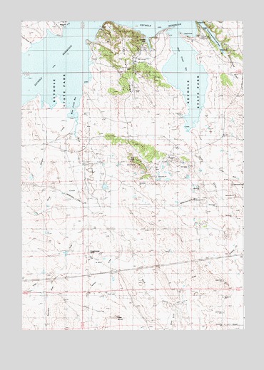
Grasshopper Butte, WY USGS Topographic Map
Click on map above to begin viewing in our Map Viewer.

This topographic map contains these locations and features:
Feature Name Type Latitude Longitude GNIS ID View Map
Berger CreekStreamN44.3375°W104.8452°1585387View Map
Berger DamDamN44.3166°W104.8689°1607300View Map
Berger ReservoirReservoirN44.3166°W104.8689°1607301View Map
Bond CreekStreamN44.3094°W104.8369°1585766View Map
Bute DamDamN44.2750°W104.8239°1607222View Map
Bute ReservoirReservoirN44.2750°W104.8239°1607223View Map
Cottonwood CreekStreamN44.3728°W104.7727°1587051View Map
Crook County Fire Department - Pine HavenBuildingN44.3580°W104.8113°2673596View Map
Deer CreekStreamN44.3722°W104.8372°1587487View Map
Dry DrawValleyN44.2583°W104.7858°1587832View Map
Eagle ButtesSummitN44.2553°W104.8230°1587971View Map
Grasshopper ButteSummitN44.2814°W104.8372°1589068View Map
Iron RunStreamN44.3161°W104.7730°1589963View Map
Joanne CreekStreamN44.2853°W104.7527°1590120View Map
Keyhole AirportAirportN44.3492°W104.8124°1605616View Map
Keyhole ReservoirReservoirN44.3567°W104.8413°1590341View Map
Lone Tree CreekStreamN44.3603°W104.8539°1601089View Map
Lower Pine RidgeRidgeN44.3564°W104.8161°1591095View Map
Mary and Stella Mulholland DamDamN44.2583°W104.8389°1607220View Map
Mary and Stella Mulholland ReservoirReservoirN44.2583°W104.8389°1607221View Map
Mule CreekStreamN44.3575°W104.7839°1601628View Map
Nefsy DrawValleyN44.2894°W104.8258°1601665View Map
Pine HavenPopulated PlaceN44.3578°W104.8105°1609353View Map
Pine Haven CemeteryCemeteryN44.3431°W104.8094°2774538View Map
Pine KnobSummitN44.3183°W104.8102°1592789View Map
Robinson DrawValleyN44.2719°W104.8555°1602568View Map
Sage DrawValleyN44.2978°W104.8316°1602682View Map
Thompson RanchLocaleN44.2925°W104.7727°1595515View Map
Town of Pine HavenCivilN44.3534°W104.8104°2413132View Map
West Fork Wind CreekStreamN44.2586°W104.7883°1604083View Map
Wind CreekStreamN44.3522°W104.8530°1604234View Map

Note: Coordinates in the location and feature list above are referenced to NAD83 datum.


Copyright (C) 2008-2025 Ryan Niemi / Sunset Dynamics ... All Rights Reserved