TopoQuest Logo
Do you find TopoQuest useful?
Help keep TopoQuest running and adding new maps/features by donating!
Bitcoin:  19c7KJd3qBynnjoSw5npx9KScwjBe4ifkT
Litecoin:  LXs6TkuXGGXo1vDsWCkWVdjQX94eUKd6ui
Home View Maps Find Maps Find Places Resources & Links


Grayback, Texas Topographic Map

USGS Map Title: Grayback, TX
USGS Map MRC: 33099H2
DRG (GeoTIFF) Download: o33099h2.tif


Neighboring USGS Topographic Map Quads:


  Lockett, TX  
34099A3
 

  Boggy Creek, TX  
34099A2
 

  Harrold, TX  
34099A1
 

  Santa Rosa Lake, TX  
33099H3
 

  Grayback, TX  
33099H2
 

  Lake Electra, TX  
33099H1
 

  Northwest Lake Kemp, TX  
33099G3
 

  Northeast Lake Kemp, TX  
33099G2
 

  Franklin Bend, TX  
33099G1


Map MRC Location:

N34°
W100°
N34°
W99°
H8 H7 H6 H5 H4 H3 H2 H1
G8 G7 G6 G5 G4 G3 G2 G1
F8 F7 F6 F5 F4 F3 F2 F1
E8 E7 E6 E5 E4 E3 E2 E1
D8 D7 D6 D5 D4 D3 D2 D1
C8 C7 C6 C5 C4 C3 C2 C1
B8 B7 B6 B5 B4 B3 B2 B1
A8 A7 A6 A5 A4 A3 A2 A1
N33°
W100°
N33°
W99°

Grayback, TX USGS 1:24K Topographic Map Preview:
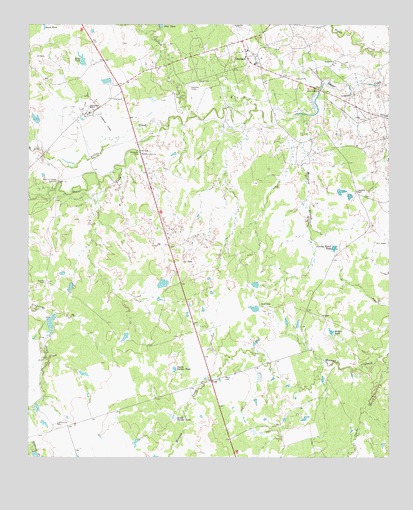
Grayback, TX USGS Topographic Map
Click on map above to begin viewing in our Map Viewer.

This topographic map contains these locations and features:
Feature Name Type Latitude Longitude GNIS ID View Map
Alamosa CampLocaleN33.9820°W99.1945°1350944View Map
Bronc TankReservoirN33.9899°W99.2318°1352926View Map
Burnett PensLocaleN33.9256°W99.2440°1353348View Map
Cattle CreekStreamN33.9026°W99.1265°1353991View Map
Cottonwood PensLocaleN33.8837°W99.2392°1355127View Map
Diving Board TankReservoirN33.9355°W99.1444°1356060View Map
GraybackPopulated PlaceN33.9906°W99.1742°1358356View Map
Hereford BranchStreamN33.9743°W99.1551°1359067View Map
Hereford PensLocaleN33.9518°W99.1373°1359068View Map
Hoot and Holler CrossingPopulated PlaceN33.9548°W99.2398°1385451View Map
Lillus CreekStreamN33.9709°W99.2015°1361192View Map
Mack CemeteryCemeteryN33.8981°W99.1823°1362038View Map
Midway CrossingPopulated PlaceN33.9629°W99.2112°1380195View Map
North Parker TankReservoirN33.9004°W99.1997°1364106View Map
Rock CrossingPopulated PlaceN33.9812°W99.1492°1380449View Map
South Parker TankReservoirN33.8865°W99.1993°1368731View Map
Turkey CreekStreamN33.9737°W99.1920°1370248View Map
Willow TankReservoirN33.9110°W99.1449°1371688View Map
Zacaweista RanchLocaleN33.9768°W99.2309°1372079View Map

Note: Coordinates in the location and feature list above are referenced to NAD83 datum.


Copyright (C) 2008-2025 Ryan Niemi / Sunset Dynamics ... All Rights Reserved