TopoQuest Logo
Do you find TopoQuest useful?
Help keep TopoQuest running and adding new maps/features by donating!
Bitcoin:  19c7KJd3qBynnjoSw5npx9KScwjBe4ifkT
Litecoin:  LXs6TkuXGGXo1vDsWCkWVdjQX94eUKd6ui
Home View Maps Find Maps Find Places Resources & Links


Great Falls, South Carolina Topographic Map

USGS Map Title: Great Falls, SC
USGS Map MRC: 34080E8
DRG (GeoTIFF) Download: o34080e8.tif


Neighboring USGS Topographic Map Quads:


  Richburg, SC  
34081F1
 

  Fort Lawn, SC  
34080F8
 

  Lancaster, SC  
34080F7
 

  Stover, SC  
34081E1
 

  Great Falls, SC  
34080E8
 

  Lancaster SE, SC  
34080E7
 

  Winnsboro, SC  
34081D1
 

  Flint Hill, SC  
34080D8
 

  Liberty Hill, SC  
34080D7


Map MRC Location:

N35°
W81°
N35°
W80°
H8 H7 H6 H5 H4 H3 H2 H1
G8 G7 G6 G5 G4 G3 G2 G1
F8 F7 F6 F5 F4 F3 F2 F1
E8 E7 E6 E5 E4 E3 E2 E1
D8 D7 D6 D5 D4 D3 D2 D1
C8 C7 C6 C5 C4 C3 C2 C1
B8 B7 B6 B5 B4 B3 B2 B1
A8 A7 A6 A5 A4 A3 A2 A1
N34°
W81°
N34°
W80°

Great Falls, SC USGS 1:24K Topographic Map Preview:
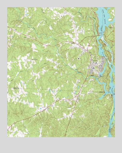
Great Falls, SC USGS Topographic Map
Click on map above to begin viewing in our Map Viewer.

This topographic map contains these locations and features:
Feature Name Type Latitude Longitude GNIS ID View Map
Allens Mill (historical)LocaleN34.5496°W80.8873°1230622View Map
Bear CreekStreamN34.6224°W80.8845°1220403View Map
Beaverdam CreekStreamN34.5971°W80.9479°1220448View Map
BeckhamvillePopulated PlaceN34.5904°W80.9198°1245030View Map
Bethesda CemeteryCemeteryN34.5304°W80.9492°1248788View Map
Bethesda ChurchChurchN34.5307°W80.9495°1245683View Map
Big IslandIslandN34.5579°W80.8840°1220711View Map
Browns - Strouds CemeteryCemeteryN34.6085°W80.9617°1230640View Map
Caldwell CrossroadPopulated PlaceN34.5738°W80.9720°1247086View Map
Camp CreekStreamN34.5860°W80.8804°1247121View Map
Cedar Creek Power PlantBuildingN34.5401°W80.8779°1236997View Map
Cedar Creek ReservoirReservoirN34.5539°W80.8783°1221443View Map
Church of ProphecyChurchN34.5715°W80.9423°1230668View Map
Dearborn-Great FallsReservoirN34.5539°W80.8783°1237715View Map
Dearborn-Great Falls DamDamN34.5594°W80.8916°1237714View Map
Debutary CreekStreamN34.5374°W80.8945°1221967View Map
Duncan Creek Watershed Number FiveReservoirN34.5368°W80.8981°1237888View Map
Ebenezer ChurchChurchN34.5957°W80.9776°1247623View Map
Fairfield County Fire Department MitfordBuildingN34.5350°W80.9433°2578388View Map
Farrars Landing (historical)LocaleN34.5468°W80.8806°1230679View Map
Fishing CreekStreamN34.5943°W80.8954°1222409View Map
Fishing Creek DamDamN34.5918°W80.8881°1238845View Map
Fishing Creek LakeReservoirN34.5924°W80.8884°1238846View Map
Fishing Creek Power PlantBuildingN34.6001°W80.8926°1230683View Map
Fishing Creek ReservoirReservoirN34.6150°W80.8856°1247757View Map
Goat IslandIslandN34.5443°W80.8804°1222734View Map
Great FallsPopulated PlaceN34.5751°W80.9020°1222851View Map
Great Falls and Dearborn Power PlantsBuildingN34.5585°W80.8915°1230691View Map
Great Falls Branch Chester County LibraryBuildingN34.5707°W80.8979°1230692View Map
Great Falls DivisionCivilN34.6058°W80.9818°1938282View Map
Great Falls Elementary SchoolSchoolN34.5718°W80.8962°1230693View Map
Great Falls Fire DepartmentBuildingN34.5703°W80.8965°2578188View Map
Great Falls Fire DepartmentBuildingN34.5802°W80.9042°2578719View Map
Great Falls High SchoolSchoolN34.5757°W80.9170°1230694View Map
Great Falls Middle SchoolSchoolN34.5676°W80.9048°1230695View Map
Great Falls of CatawbaFallsN34.5790°W80.8779°1230696View Map
Great Falls Police DepartmentBuildingN34.5714°W80.8987°2734260View Map
Great Falls Rescue SquadBuildingN34.5800°W80.9041°2739607View Map
Great Falls ReservoirReservoirN34.5593°W80.8915°1222852View Map
Great Falls-Dearborn DamDamN34.5568°W80.8931°1238847View Map
Great Falls-Dearborn ReservoirReservoirN34.5568°W80.8931°1238848View Map
Gunthorne CemeteryCemeteryN34.5579°W80.9270°1230697View Map
Heath ChapelChurchN34.6201°W80.9306°1245935View Map
Hill IslandIslandN34.5679°W80.8779°1245987View Map
Hodges BranchStreamN34.5690°W80.9295°1223200View Map
Interchange 48CrossingN34.5076°W80.9990°1228246View Map
Kingsburys Ferry (historical)CrossingN34.5315°W80.8756°1251807View Map
Lackys Island (historical)IslandN34.6146°W80.8884°1241690View Map
Little Rocky CreekStreamN34.5832°W80.9420°1246428View Map
Masseys Mill (historical)LocaleN34.6146°W80.8859°1241707View Map
McDowell IslandIslandN34.5146°W80.8765°1246590View Map
MitfordPopulated PlaceN34.5274°W80.9554°1231552View Map
Mitford Church (historical)ChurchN34.5354°W80.9420°1237044View Map
Mitford SchoolSchoolN34.5224°W80.9667°1237045View Map
Mount Zion CemeteryCemeteryN34.5546°W80.9679°1224815View Map
Mount Zion ChurchChurchN34.5290°W80.9559°1249724View Map
Mount Zion ChurchChurchN34.5693°W80.9040°1224837View Map
Mountain IslandIslandN34.5826°W80.8851°1224855View Map
NitroleePopulated PlaceN34.5829°W80.9067°1230727View Map
Pickett IslandIslandN34.5574°W80.8759°1250082View Map
Pine Grove ChurchChurchN34.5360°W80.9420°1225444View Map
Pleasant Grove ChurchChurchN34.5365°W80.9184°1225534View Map
Republic Golf CourseLocaleN34.5682°W80.9220°1230744View Map
Republic MillsLocaleN34.5657°W80.8901°1230745View Map
Riverside Club HouseBuildingN34.6093°W80.8795°1241748View Map
Rocky CreekStreamN34.5563°W80.8959°1250440View Map
Rocky Creek-Cedar Creek DamDamN34.5301°W80.8798°1238843View Map
Rocky Creek-Cedar Creek ReservoirReservoirN34.5301°W80.8798°1238844View Map
RossvillePopulated PlaceN34.6035°W80.9926°1231749View Map
Rossville ChurchChurchN34.6071°W80.9895°1230747View Map
Rossville Fire DepartmentBuildingN34.6047°W80.9938°2578588View Map
Rossville School (historical)SchoolN34.6076°W80.9906°1230749View Map
Rossvillle Community CenterBuildingN34.5988°W80.9792°1230748View Map
South Carolina Noname 20020 D-0532 DamDamN34.5635°W80.9798°1239021View Map
South Carolina Noname 30005 D-2985 DamDamN34.5368°W80.8981°1237887View Map
Springs ParkPopulated PlaceN34.6063°W80.8820°1231821View Map
Town of Great FallsCivilN34.5753°W80.9048°2406608View Map
Turkey BranchStreamN34.5646°W80.9206°1227232View Map
Varnadores Store (historical)LocaleN34.5974°W80.9198°1230764View Map

Note: Coordinates in the location and feature list above are referenced to NAD83 datum.


Copyright (C) 2008-2024 Ryan Niemi / Sunset Dynamics ... All Rights Reserved