TopoQuest Logo
Do you find TopoQuest useful?
Help keep TopoQuest running and adding new maps/features by donating!
Bitcoin:  19c7KJd3qBynnjoSw5npx9KScwjBe4ifkT
Litecoin:  LXs6TkuXGGXo1vDsWCkWVdjQX94eUKd6ui
Home View Maps Find Maps Find Places Resources & Links


Greenbrier, Indiana Topographic Map

USGS Map Title: Greenbrier, IN
USGS Map MRC: 38086D5
DRG (GeoTIFF) Download: o38086d5.tif


Neighboring USGS Topographic Map Quads:


  Hillham, IN  
38086E6
 

  French Lick, IN  
38086E5
 

  Paoli, IN  
38086E4
 

  Cuzco, IN  
38086D6
 

  Greenbrier, IN  
38086D5
 

  Valeene, IN  
38086D4
 

  Birdseye, IN  
38086C6
 

  Taswell, IN  
38086C5
 

  English, IN  
38086C4


Map MRC Location:

N39°
W87°
N39°
W86°
H8 H7 H6 H5 H4 H3 H2 H1
G8 G7 G6 G5 G4 G3 G2 G1
F8 F7 F6 F5 F4 F3 F2 F1
E8 E7 E6 E5 E4 E3 E2 E1
D8 D7 D6 D5 D4 D3 D2 D1
C8 C7 C6 C5 C4 C3 C2 C1
B8 B7 B6 B5 B4 B3 B2 B1
A8 A7 A6 A5 A4 A3 A2 A1
N38°
W87°
N38°
W86°

Greenbrier, IN USGS 1:24K Topographic Map Preview:
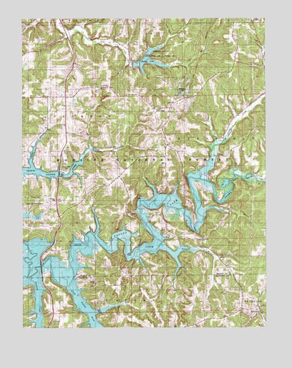
Greenbrier, IN USGS Topographic Map
Click on map above to begin viewing in our Map Viewer.

This topographic map contains these locations and features:
Feature Name Type Latitude Longitude GNIS ID View Map
BrownstownPopulated PlaceN38.3809°W86.5030°450721View Map
Cane BranchStreamN38.4201°W86.5322°450751View Map
County Line BranchStreamN38.3959°W86.6230°450806View Map
Dumplin BranchStreamN38.4070°W86.5555°450873View Map
EthelPopulated PlaceN38.4037°W86.5244°450895View Map
Fairview ChurchChurchN38.3928°W86.5878°450900View Map
Fleming CreekStreamN38.3956°W86.6214°450917View Map
Flick SchoolSchoolN38.4478°W86.6028°450918View Map
GreenbrierPopulated PlaceN38.4631°W86.5558°450982View Map
Grimes Lake (historical)LakeN38.4353°W86.5314°452446View Map
Jericho SchoolSchoolN38.3756°W86.5367°451100View Map
Jordan BranchStreamN38.4389°W86.6208°451107View Map
Little Patoka RiverStreamN38.3917°W86.6022°451158View Map
Lomax HollowValleyN38.4929°W86.5491°451171View Map
Lowe SchoolSchoolN38.4417°W86.5514°451179View Map
McDonald ChurchChurchN38.4106°W86.5328°451207View Map
Newton StewartPopulated PlaceN38.3751°W86.6250°452173View Map
Olinger LakeReservoirN38.4198°W86.6172°451805View Map
Olinger Lake DamDamN38.4217°W86.6200°451806View Map
Orange County Rural Volunteer Fire Department District 1BuildingN38.4905°W86.5757°2626343View Map
Patoka ChurchChurchN38.4198°W86.5686°451315View Map
Patoka Memorial CemeteryCemeteryN38.4389°W86.6019°449806View Map
Patoka Memorial CemeteryCemeteryN38.4387°W86.6028°452529View Map
South Liberty ChurchChurchN38.4720°W86.5850°451484View Map
Spears Lookout TowerTowerN38.3753°W86.5480°451488View Map
Springs Valley State Fish and Wildlife AreaParkN38.4853°W86.5528°451713View Map
SVC District French Lick Dam F-7DamN38.4817°W86.5680°451743View Map
Tillery HillSummitN38.4264°W86.6064°451566View Map
Tillery Hill State Recreation AreaParkN38.4264°W86.6180°451712View Map
Township of GreenfieldCivilN38.4472°W86.5131°453352View Map
Tucker LakeReservoirN38.4829°W86.5598°451714View Map
Wildwood LakeReservoirN38.4702°W86.5427°451626View Map
Youngs CreekStreamN38.4334°W86.5333°451652View Map

Note: Coordinates in the location and feature list above are referenced to NAD83 datum.


Copyright (C) 2008-2024 Ryan Niemi / Sunset Dynamics ... All Rights Reserved