TopoQuest Logo
Do you find TopoQuest useful?
Help keep TopoQuest running and adding new maps/features by donating!
Bitcoin:  19c7KJd3qBynnjoSw5npx9KScwjBe4ifkT
Litecoin:  LXs6TkuXGGXo1vDsWCkWVdjQX94eUKd6ui
Home View Maps Find Maps Find Places Resources & Links


Greybull South, Wyoming Topographic Map

USGS Map Title: Greybull South, WY
USGS Map MRC: 44108D1
DRG (GeoTIFF) Download: o44108d1.tif


Neighboring USGS Topographic Map Quads:


  Sheep Canyon, WY  
44108E2
 

  Greybull North, WY  
44108E1
 

  Devils Kitchen, WY  
44107E8
 

  Gould Butte, WY  
44108D2
 

  Greybull South, WY  
44108D1
 

  Wild Horse Flats, WY  
44107D8
 

  Jones Reservoir, WY  
44108C2
 

  Orchard Bench, WY  
44108C1
 

  Manderson, WY  
44107C8


Map MRC Location:

N45°
W109°
N45°
W108°
H8 H7 H6 H5 H4 H3 H2 H1
G8 G7 G6 G5 G4 G3 G2 G1
F8 F7 F6 F5 F4 F3 F2 F1
E8 E7 E6 E5 E4 E3 E2 E1
D8 D7 D6 D5 D4 D3 D2 D1
C8 C7 C6 C5 C4 C3 C2 C1
B8 B7 B6 B5 B4 B3 B2 B1
A8 A7 A6 A5 A4 A3 A2 A1
N44°
W109°
N44°
W108°

Greybull South, WY USGS 1:24K Topographic Map Preview:
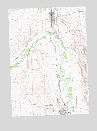
Greybull South, WY USGS Topographic Map
Click on map above to begin viewing in our Map Viewer.

This topographic map contains these locations and features:
Feature Name Type Latitude Longitude GNIS ID View Map
Atwood's Family AmbulanceBuildingN44.3809°W108.0403°2673695View Map
BasinPopulated PlaceN44.3800°W108.0390°1585173View Map
Basin Pioneer CemeteryCemeteryN44.3815°W108.0506°2774506View Map
Basin Police DepartmentBuildingN44.3800°W108.0383°2752636View Map
Basin Post OfficePost OfficeN44.3815°W108.0395°2765598View Map
Beaver Hill MinesMineN44.4908°W108.0565°1704167View Map
Beaver Hill MinesMineN44.4833°W108.0423°1704170View Map
Big Horn County Fire Protection District 2 BasinBuildingN44.3821°W108.0377°2673427View Map
Big Horn County Sheriff's OfficeBuildingN44.3821°W108.0397°2752600View Map
Big Horn Redi-Mix Incorporated MineMineN44.4825°W108.0482°1704168View Map
Bonnie Bluejacket Nursing HomeHospitalN44.4891°W108.0562°1794909View Map
Donald J Ruhl Memorial Cemetery - Greybull Cemetery - Hillside CemeteryCemeteryN44.4961°W108.0734°1589145View Map
Dresser Bentonite Clay MineMineN44.4725°W108.0301°1704172View Map
GreybullPopulated PlaceN44.4891°W108.0562°1589144View Map
Greybull Elementary SchoolSchoolN44.4821°W108.0500°1795422View Map
Greybull Emergency Medical ServicesBuildingN44.4907°W108.0548°2673661View Map
Greybull Fire DepartmentBuildingN44.4908°W108.0548°2673467View Map
Greybull High SchoolSchoolN44.4965°W108.0560°1795420View Map
Greybull Middle SchoolSchoolN44.4973°W108.0572°1795421View Map
Greybull MineMineN44.4941°W108.0198°1704173View Map
Greybull Police DepartmentBuildingN44.4881°W108.0541°2752679View Map
Greybull Post OfficePost OfficeN44.4886°W108.0529°2767849View Map
Greybull RiverStreamN44.4708°W108.0498°1600093View Map
KZMQ-AM (Greybull)TowerN44.4502°W108.0495°1608804View Map
Laura Irwin Elementary SchoolSchoolN44.3798°W108.0499°1795424View Map
Mount View Cemetery - Basin CemeteryCemeteryN44.3872°W108.0620°1585174View Map
Riverside High SchoolSchoolN44.3797°W108.0469°1795423View Map
Schroll DrawValleyN44.4916°W108.0459°1594035View Map
South Big Horn County Critical Access HospitalBuildingN44.4335°W108.0507°1594594View Map
Tilard CanalCanalN44.4052°W108.0195°1595566View Map
Tin Can AlleyValleyN44.4897°W108.0462°1595581View Map
Town of BasinCivilN44.3806°W108.0466°2411666View Map
Town of GreybullCivilN44.4887°W108.0592°2412710View Map
Wyoming Retirement CenterHospitalN44.3800°W108.0390°1794901View Map

Note: Coordinates in the location and feature list above are referenced to NAD83 datum.


Copyright (C) 2008-2025 Ryan Niemi / Sunset Dynamics ... All Rights Reserved