TopoQuest Logo
Do you find TopoQuest useful?
Help keep TopoQuest running and adding new maps/features by donating!
Bitcoin:  19c7KJd3qBynnjoSw5npx9KScwjBe4ifkT
Litecoin:  LXs6TkuXGGXo1vDsWCkWVdjQX94eUKd6ui
Home View Maps Find Maps Find Places Resources & Links


Groveland, Georgia Topographic Map

USGS Map Title: Groveland, GA
USGS Map MRC: 32081B6
DRG (GeoTIFF) Download: o32081b6.tif


Neighboring USGS Topographic Map Quads:


  Nevils, GA  
32081C7
 

  Denmark, GA  
32081C6
 

  Stilson, GA  
32081C5
 

  Daisy, GA  
32081B7
 

  Groveland, GA  
32081B6
 

  Lanier, GA  
32081B5
 

  Glissons Millpond, GA  
32081A7
 

  Willie, GA  
32081A6
 

  Letford, GA  
32081A5


Map MRC Location:

N33°
W82°
N33°
W81°
H8 H7 H6 H5 H4 H3 H2 H1
G8 G7 G6 G5 G4 G3 G2 G1
F8 F7 F6 F5 F4 F3 F2 F1
E8 E7 E6 E5 E4 E3 E2 E1
D8 D7 D6 D5 D4 D3 D2 D1
C8 C7 C6 C5 C4 C3 C2 C1
B8 B7 B6 B5 B4 B3 B2 B1
A8 A7 A6 A5 A4 A3 A2 A1
N32°
W82°
N32°
W81°

Groveland, GA USGS 1:24K Topographic Map Preview:
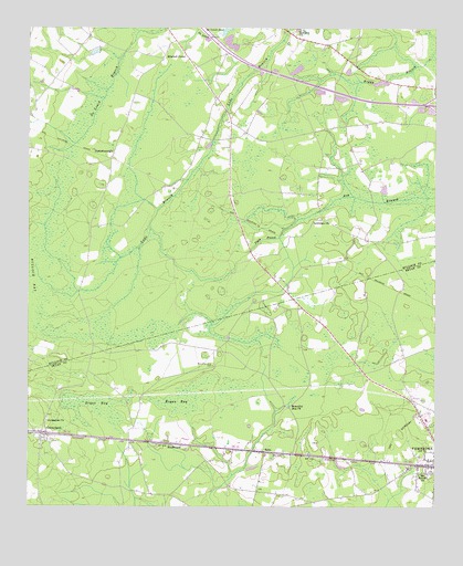
Groveland, GA USGS Topographic Map
Click on map above to begin viewing in our Map Viewer.

This topographic map contains these locations and features:
Feature Name Type Latitude Longitude GNIS ID View Map
Beautiful Zion CemeteryCemeteryN32.1621°W81.6929°310970View Map
Beautiful Zion ChurchChurchN32.1516°W81.6696°310971View Map
Boggy BaySwampN32.2460°W81.6254°350292View Map
Bryan BaySwampN32.1535°W81.7040°311928View Map
Bulloch BaySwampN32.1857°W81.7454°312026View Map
Crawford Hendrix Farm AirportAirportN32.2395°W81.6379°2443618View Map
Dorothy School (historical)SchoolN32.2316°W81.6921°350330View Map
Futch BranchStreamN32.2002°W81.6673°314467View Map
GrovelandPopulated PlaceN32.1444°W81.7457°356121View Map
Groveland CemeteryCemeteryN32.1421°W81.7426°350511View Map
Holy ChurchChurchN32.1591°W81.6346°350512View Map
Jerusalem ChurchChurchN32.1477°W81.7440°316096View Map
Lawrence CemeteryCemeteryN32.2002°W81.6604°350383View Map
Lawrence ChurchChurchN32.2005°W81.6598°316695View Map
Midway School (historical)SchoolN32.1283°W81.7057°334948View Map
Mitchell ForksPopulated PlaceN32.2435°W81.7023°332404View Map
Mitchell School (historical)SchoolN32.1999°W81.6582°350400View Map
Mount Moriah ChurchChurchN32.1335°W81.6296°318694View Map
North Bryan County Fire Department Bacontown Station 6BuildingN32.1374°W81.6960°2603601View Map
Northside ChurchChurchN32.1577°W81.6290°350524View Map
Pembroke Christian ChurchChurchN32.1364°W81.6256°2502347View Map
Pembroke Post OfficePost OfficeN32.1311°W81.6252°2502490View Map
Red Hill CemeteryCemeteryN32.2488°W81.6684°350432View Map
Red Hill ChurchChurchN32.2485°W81.6682°321386View Map
RekaPopulated PlaceN32.1394°W81.6773°332828View Map
SouthwardPopulated PlaceN32.1413°W81.7034°333093View Map
Starlins Pond (historical)LakeN32.2308°W81.6451°334950View Map
StatesboroughPopulated PlaceN32.2177°W81.7237°333118View Map

Note: Coordinates in the location and feature list above are referenced to NAD83 datum.


Copyright (C) 2008-2024 Ryan Niemi / Sunset Dynamics ... All Rights Reserved