TopoQuest Logo
Do you find TopoQuest useful?
Help keep TopoQuest running and adding new maps/features by donating!
Bitcoin:  19c7KJd3qBynnjoSw5npx9KScwjBe4ifkT
Litecoin:  LXs6TkuXGGXo1vDsWCkWVdjQX94eUKd6ui
Home View Maps Find Maps Find Places Resources & Links


Haddens, Louisiana Topographic Map

USGS Map Title: Haddens, LA
USGS Map MRC: 31093B5
DRG (GeoTIFF) Download: o31093b5.tif


Neighboring USGS Topographic Map Quads:


  Negreet SW, TX  
31093C6
 

  Toro, LA  
31093C5
 

  Hornbeck, LA  
31093C4
 

  Fairmount, TX  
31093B6
 

  Haddens, LA  
31093B5
 

  Little Sandy Creek, LA  
31093B4
 

  Wiergate, TX  
31093A6
 

  Wiergate SE, TX  
31093A5
 

  Burr Ferry, LA  
31093A4


Map MRC Location:

N32°
W94°
N32°
W93°
H8 H7 H6 H5 H4 H3 H2 H1
G8 G7 G6 G5 G4 G3 G2 G1
F8 F7 F6 F5 F4 F3 F2 F1
E8 E7 E6 E5 E4 E3 E2 E1
D8 D7 D6 D5 D4 D3 D2 D1
C8 C7 C6 C5 C4 C3 C2 C1
B8 B7 B6 B5 B4 B3 B2 B1
A8 A7 A6 A5 A4 A3 A2 A1
N31°
W94°
N31°
W93°

Haddens, LA USGS 1:24K Topographic Map Preview:
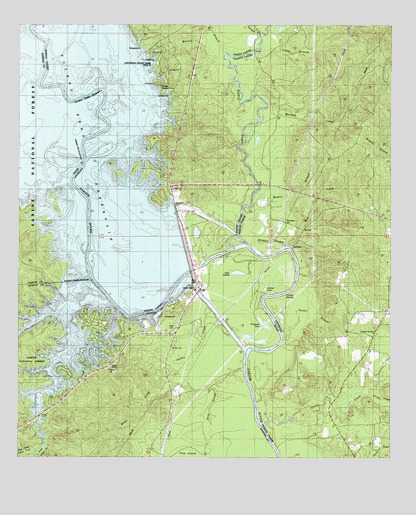
Haddens, LA USGS Topographic Map
Click on map above to begin viewing in our Map Viewer.

This topographic map contains these locations and features:
Feature Name Type Latitude Longitude GNIS ID View Map
Alligator LakeLakeN31.2263°W93.6013°1381314View Map
Babel CreekStreamN31.1555°W93.5652°1381349View Map
Bayou ToroStreamN31.1855°W93.5530°553534View Map
Brushy CreekStreamN31.1435°W93.5074°547137View Map
Buck CreekStreamN31.1713°W93.6038°1381544View Map
Bullick BranchStreamN31.2488°W93.6224°1381553View Map
Camp BranchStreamN31.2427°W93.5466°547170View Map
Coldwater BranchStreamN31.2138°W93.6146°1381679View Map
Crossway SloughGutN31.1860°W93.5891°547269View Map
Deep SloughGutN31.1427°W93.5571°1381752View Map
Dry CreekStreamN31.2341°W93.6182°1381794View Map
Ferguson LakeLakeN31.1640°W93.5435°1381868View Map
Freedom Rest ChurchChurchN31.1613°W93.5057°547376View Map
Gravel Hill School (historical)SchoolN31.2099°W93.5671°546117View Map
Green Lake (historical)LakeN31.2371°W93.6196°1381287View Map
HaddensPopulated PlaceN31.1863°W93.5332°547431View Map
Horsepen CreekStreamN31.2477°W93.5443°547478View Map
Horseshoe LakeLakeN31.2171°W93.5960°547480View Map
Horseshoe SloughLakeN31.2130°W93.6116°1382036View Map
Hunter BranchStreamN31.1963°W93.5502°547489View Map
Indian CreekStreamN31.1702°W93.5943°1382060View Map
J and L MarinaLocaleN31.2141°W93.5821°546126View Map
Lake LenoreLakeN31.1785°W93.5514°1382137View Map
Leland LakeLakeN31.1741°W93.5422°1382136View Map
Louisiana State Park Site 15ParkN31.2391°W93.5782°546133View Map
Macelva CreekStreamN31.2271°W93.5413°555203View Map
McCowan BendBendN31.2210°W93.5946°547664View Map
Metcalf BranchStreamN31.2421°W93.5557°547684View Map
Mill CreekStreamN31.1863°W93.5355°547702View Map
Mill CreekStreamN31.2094°W93.6049°1382298View Map
Mount Olive ChurchChurchN31.1566°W93.5732°1382342View Map
Packer BranchStreamN31.1588°W93.5360°547808View Map
Packer SwampStreamN31.1718°W93.5307°547809View Map
Rock (historical)Populated PlaceN31.1946°W93.5766°546164View Map
Sand BranchStreamN31.1674°W93.5910°1382694View Map
Sandy CreekStreamN31.1344°W93.5424°547963View Map
Sandy Creek ChurchChurchN31.1652°W93.5141°547968View Map
Scott CemeteryCemeteryN31.1624°W93.5721°1382729View Map
South Prong Indian CreekStreamN31.1294°W93.6160°1382784View Map
South Toledo BendPopulated PlaceN31.1532°W93.6046°1852771View Map
South Toledo Bend Census Designated PlaceCensusN31.1568°W93.6075°2408775View Map
South Toledo Fire DepartmentBuildingN31.2249°W93.5701°2673037View Map
Sutton CreekStreamN31.1571°W93.5480°1382835View Map
ToledoPopulated PlaceN31.1744°W93.5613°1382870View Map
Toledo Bend DamDamN31.1970°W93.5723°556732View Map
Toledo Bend MarinaLocaleN31.2249°W93.5760°546193View Map
Toledo Bend Volunteer Fire DepartmentBuildingN31.1473°W93.6040°2655163View Map
Toledo CemeteryCemeteryN31.1755°W93.5632°1382871View Map
West Prong Indian CreekStreamN31.1438°W93.6193°1382939View Map
Wildcat BranchStreamN31.1857°W93.5366°548149View Map

Note: Coordinates in the location and feature list above are referenced to NAD83 datum.


Copyright (C) 2008-2024 Ryan Niemi / Sunset Dynamics ... All Rights Reserved