TopoQuest Logo
Do you find TopoQuest useful?
Help keep TopoQuest running and adding new maps/features by donating!
Bitcoin:  19c7KJd3qBynnjoSw5npx9KScwjBe4ifkT
Litecoin:  LXs6TkuXGGXo1vDsWCkWVdjQX94eUKd6ui
Home View Maps Find Maps Find Places Resources & Links


Halls Crossing, Utah Topographic Map

USGS Map Title: Halls Crossing, UT
USGS Map MRC: 37110D6
DRG (GeoTIFF) Download: o37110d6.tif


Neighboring USGS Topographic Map Quads:


  Hall Mesa, UT  
37110E7
 

  Bullfrog, UT  
37110E6
 

  Knowles Canyon, UT  
37110E5
 

  The Rincon NE, UT  
37110D7
 

  Halls Crossing, UT  
37110D6
 

  Halls Crossing NE, UT  
37110D5
 

  The Rincon, UT  
37110C7
 

  Alcove Canyon, UT  
37110C6
 

  Nokai Dome, UT  
37110C5


Map MRC Location:

N38°
W111°
N38°
W110°
H8 H7 H6 H5 H4 H3 H2 H1
G8 G7 G6 G5 G4 G3 G2 G1
F8 F7 F6 F5 F4 F3 F2 F1
E8 E7 E6 E5 E4 E3 E2 E1
D8 D7 D6 D5 D4 D3 D2 D1
C8 C7 C6 C5 C4 C3 C2 C1
B8 B7 B6 B5 B4 B3 B2 B1
A8 A7 A6 A5 A4 A3 A2 A1
N37°
W111°
N37°
W110°

Halls Crossing, UT USGS 1:24K Topographic Map Preview:
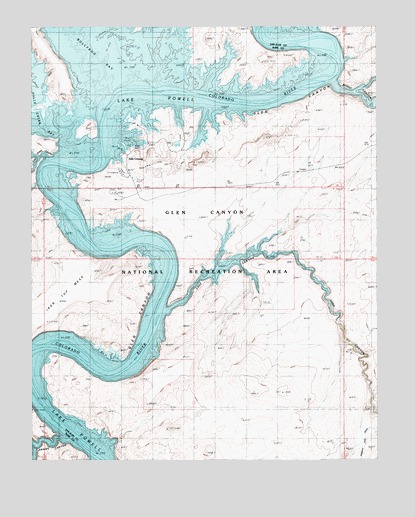
Halls Crossing, UT USGS Topographic Map
Click on map above to begin viewing in our Map Viewer.

This topographic map contains these locations and features:
Feature Name Type Latitude Longitude GNIS ID View Map
Amphitheater Bar (historical)BarN37.4900°W110.6468°1450226View Map
Anderson Bar (historical)BarN37.4111°W110.7390°1450228View Map
Anderson Camp (historical)LocaleN37.4117°W110.7413°1450229View Map
Annies CanyonValleyN37.3819°W110.7413°1450231View Map
Aztec Rapids (historical)RapidsN37.4842°W110.6424°1450236View Map
Big BarBarN37.4767°W110.7151°1450248View Map
Boston Bar (historical)BarN37.4561°W110.7424°1450261View Map
Burro Bar (historical)BarN37.4644°W110.7385°1450269View Map
Camp Stone (historical)LocaleN37.4794°W110.6751°1450274View Map
Gretchen Bar (historical)BarN37.3842°W110.7318°1450370View Map
Halls Bar (historical)BarN37.4644°W110.7313°1450373View Map
Halls CrossingPopulated PlaceN37.4569°W110.7129°1437579View Map
Halls Crossing Airport (historical)AirportN37.4667°W110.7007°1434545View Map
Halls Crossing CampgroundLocaleN37.4444°W110.7063°1435644View Map
Halls Crossing Census Designated PlaceCensusN37.4578°W110.6830°2408346View Map
Halls Crossing MarinaLocaleN37.4628°W110.7163°1455310View Map
Halls Crossing RV CampgroundLocaleN37.4583°W110.7035°1435645View Map
Iron Top MesaSummitN37.4255°W110.7371°1429055View Map
Lake CanyonValleyN37.4186°W110.7013°1429421View Map
Lost Eden CanyonValleyN37.4617°W110.7479°1450425View Map
Moqui CanyonValleyN37.4836°W110.6410°1425016View Map
New Year Bar (historical)BarN37.4755°W110.6796°1450445View Map
Schock Rapids (historical)RapidsN37.4061°W110.7368°1436327View Map
Schock Trail Base (historical)LocaleN37.4061°W110.7279°1450490View Map
The AmphitheaterBasinN37.4900°W110.6368°1450225View Map
The Hoskaninni Dredge (historical)LocaleN37.4828°W110.7024°1435712View Map

Note: Coordinates in the location and feature list above are referenced to NAD83 datum.


Copyright (C) 2008-2025 Ryan Niemi / Sunset Dynamics ... All Rights Reserved