TopoQuest Logo
Do you find TopoQuest useful?
Help keep TopoQuest running and adding new maps/features by donating!
Bitcoin:  19c7KJd3qBynnjoSw5npx9KScwjBe4ifkT
Litecoin:  LXs6TkuXGGXo1vDsWCkWVdjQX94eUKd6ui
Home View Maps Find Maps Find Places Resources & Links


Avalon, New Jersey Topographic Map

USGS Map Title: Avalon, NJ
USGS Map MRC: 39074A6
DRG (GeoTIFF) Download: o39074a6.tif


Neighboring USGS Topographic Map Quads:


  Woodbine, NJ  
39074B7
 

  Sea Isle City, NJ  
39074B6


  Stone Harbor, NJ  
39074A7
 

  Avalon, NJ  
39074A6


  Wildwood, NJ  
38074H7


Map MRC Location:

N40°
W75°
N40°
W74°
H8 H7 H6 H5 H4 H3 H2 H1
G8 G7 G6 G5 G4 G3 G2 G1
F8 F7 F6 F5 F4 F3 F2 F1
E8 E7 E6 E5 E4 E3 E2 E1
D8 D7 D6 D5 D4 D3 D2 D1
C8 C7 C6 C5 C4 C3 C2 C1
B8 B7 B6 B5 B4 B3 B2 B1
A8 A7 A6 A5 A4 A3 A2 A1
N39°
W75°
N39°
W74°

Avalon, NJ USGS 1:24K Topographic Map Preview:
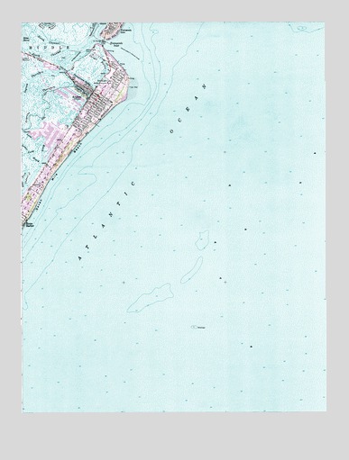
Avalon, NJ USGS Topographic Map
Click on map above to begin viewing in our Map Viewer.

This topographic map contains these locations and features:
Feature Name Type Latitude Longitude GNIS ID View Map
AvalonPopulated PlaceN39.1012°W74.7177°874428View Map
Avalon Elementary SchoolSchoolN39.0959°W74.7254°2333237View Map
Avalon Police DepartmentBuildingN39.0957°W74.7234°2730531View Map
Avalon Rescue SquadBuildingN39.0956°W74.7236°2659993View Map
Avalon Volunteer Fire DepartmentBuildingN39.0954°W74.7238°2401809View Map
Avalon Yacht ClubLocaleN39.1159°W74.7210°884412View Map
Blue Fish HarborHarborN39.0898°W74.7379°883089View Map
Borough of AvalonCivilN39.0906°W74.7357°885146View Map
Cornell HarborGutN39.1134°W74.7168°875654View Map
East Fork Oldman CreekGutN39.0729°W74.7482°876051View Map
Gravens ThorofareChannelN39.0979°W74.7388°876732View Map
Ingram ThorofareChannelN39.1068°W74.7463°877342View Map
Long ReachGutN39.0868°W74.7402°877926View Map
North ChannelChannelN39.1190°W74.7388°878845View Map
Pennsylvania HarborBayN39.1065°W74.7235°879220View Map
Princeton HarborBayN39.1032°W74.7243°879493View Map
Seven Mile BeachBeachN39.0729°W74.7393°880479View Map
South ChannelChannelN39.1151°W74.7388°880722View Map
The LumpBarN39.1229°W74.6346°874194View Map
Townsends InletBayN39.1179°W74.7143°881228View Map
Whale HarborHarborN39.0909°W74.7427°883091View Map
Yale HarborHarborN39.0876°W74.7366°883088View Map

Note: Coordinates in the location and feature list above are referenced to NAD83 datum.


Copyright (C) 2008-2024 Ryan Niemi / Sunset Dynamics ... All Rights Reserved