TopoQuest Logo
Do you find TopoQuest useful?
Help keep TopoQuest running and adding new maps/features by donating!
Bitcoin:  19c7KJd3qBynnjoSw5npx9KScwjBe4ifkT
Litecoin:  LXs6TkuXGGXo1vDsWCkWVdjQX94eUKd6ui
Home View Maps Find Maps Find Places Resources & Links


Harford, New York Topographic Map

USGS Map Title: Harford, NY
USGS Map MRC: 42076D2
DRG (GeoTIFF) Download: o42076d2.tif


Neighboring USGS Topographic Map Quads:


  Groton, NY  
42076E3
 

  Cortland, NY  
42076E2
 

  McGraw, NY  
42076E1
 

  Dryden, NY  
42076D3
 

  Harford, NY  
42076D2
 

  Marathon, NY  
42076D1
 

  Speedsville, NY  
42076C3
 

  Richford, NY  
42076C2
 

  Lisle, NY  
42076C1


Map MRC Location:

N43°
W77°
N43°
W76°
H8 H7 H6 H5 H4 H3 H2 H1
G8 G7 G6 G5 G4 G3 G2 G1
F8 F7 F6 F5 F4 F3 F2 F1
E8 E7 E6 E5 E4 E3 E2 E1
D8 D7 D6 D5 D4 D3 D2 D1
C8 C7 C6 C5 C4 C3 C2 C1
B8 B7 B6 B5 B4 B3 B2 B1
A8 A7 A6 A5 A4 A3 A2 A1
N42°
W77°
N42°
W76°

Harford, NY USGS 1:24K Topographic Map Preview:
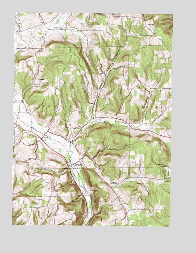
Harford, NY USGS Topographic Map
Click on map above to begin viewing in our Map Viewer.

This topographic map contains these locations and features:
Feature Name Type Latitude Longitude GNIS ID View Map
Babcock HollowValleyN42.4376°W76.1866°942750View Map
Birthplace of John D RockefellerLocaleN42.3998°W76.1669°944034View Map
Carpenter Farm CemeteryCemeteryN42.4480°W76.2473°2541961View Map
Cornell Lane CemeteryCemeteryN42.4430°W76.2454°2541962View Map
Franks CornersLocaleN42.4903°W76.2127°950638View Map
HarfordPopulated PlaceN42.4262°W76.2266°952226View Map
Harford CemeteryCemeteryN42.4248°W76.2259°2541963View Map
Harford Fire DepartmentBuildingN42.4284°W76.2244°2701010View Map
Harford MillsPopulated PlaceN42.4115°W76.2013°952227View Map
Harford Mills CemeteryCemeteryN42.4097°W76.2039°2541964View Map
Harford Post OfficePost OfficeN42.4274°W76.2301°2617954View Map
Harmony United Methodist ChurchChurchN42.4263°W76.2266°2616445View Map
Jon-Lin FarmLocaleN42.4936°W76.2131°2519066View Map
Quail HollowValleyN42.4359°W76.1469°962029View Map
Saltsman Dairy FarmLocaleN42.4817°W76.2272°2519071View Map
Town of HarfordCivilN42.4443°W76.2072°979047View Map
Virgil MountainSummitN42.4931°W76.1397°968569View Map

Note: Coordinates in the location and feature list above are referenced to NAD83 datum.


Copyright (C) 2008-2024 Ryan Niemi / Sunset Dynamics ... All Rights Reserved