TopoQuest Logo
Do you find TopoQuest useful?
Help keep TopoQuest running and adding new maps/features by donating!
Bitcoin:  19c7KJd3qBynnjoSw5npx9KScwjBe4ifkT
Litecoin:  LXs6TkuXGGXo1vDsWCkWVdjQX94eUKd6ui
Home View Maps Find Maps Find Places Resources & Links


Avant SE, Oklahoma Topographic Map

USGS Map Title: Avant SE, OK
USGS Map MRC: 36096C1
DRG (GeoTIFF) Download: o36096c1.tif


Neighboring USGS Topographic Map Quads:


  Avant NW, OK  
36096D2
 

  Avant, OK  
36096D1
 

  Vera, OK  
36095D8
 

  Avant SW, OK  
36096C2
 

  Avant SE, OK  
36096C1
 

  Sperry, OK  
36095C8
 

  Wekiwa, OK  
36096B2
 

  Sand Springs, OK  
36096B1
 

  Tulsa, OK  
36095B8


Map MRC Location:

N37°
W97°
N37°
W96°
H8 H7 H6 H5 H4 H3 H2 H1
G8 G7 G6 G5 G4 G3 G2 G1
F8 F7 F6 F5 F4 F3 F2 F1
E8 E7 E6 E5 E4 E3 E2 E1
D8 D7 D6 D5 D4 D3 D2 D1
C8 C7 C6 C5 C4 C3 C2 C1
B8 B7 B6 B5 B4 B3 B2 B1
A8 A7 A6 A5 A4 A3 A2 A1
N36°
W97°
N36°
W96°

Avant SE, OK USGS 1:24K Topographic Map Preview:
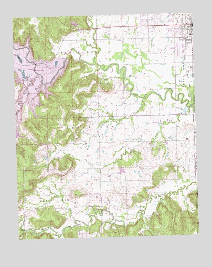
Avant SE, OK USGS Topographic Map
Click on map above to begin viewing in our Map Viewer.

This topographic map contains these locations and features:
Feature Name Type Latitude Longitude GNIS ID View Map
Ascension ChurchChurchN36.3684°W96.0128°1809998View Map
Captain CemeteryCemeteryN36.3402°W96.0460°1090953View Map
City of SkiatookCivilN36.3037°W96.1015°2413294View Map
Country Corner Fire DistrictBuildingN36.3182°W96.0695°2657041View Map
Dad CreekStreamN36.3395°W96.1142°1091911View Map
Delaware ChurchChurchN36.2540°W96.1228°1092028View Map
First Baptist ChurchChurchN36.3618°W96.0144°1809999View Map
Goose CreekStreamN36.2601°W96.0853°1093261View Map
Intermediate Elementary SchoolSchoolN36.3603°W96.0256°2713082View Map
Lakeview Southern Baptist ChurchChurchN36.3693°W96.0289°1810000View Map
Lily Pad LakeReservoirN36.3520°W96.1211°1094642View Map
Marrs Elementary SchoolSchoolN36.3579°W96.0001°1819343View Map
Newman Middle SchoolSchoolN36.3629°W96.0019°2713079View Map
Oknoname 113001 DamDamN36.2901°W96.0536°1751340View Map
Oknoname 113001 ReservoirReservoirN36.2871°W96.0524°1751341View Map
Osage Gardens CemeteryCemeteryN36.3676°W96.0300°1096315View Map
Quapaw CreekStreamN36.3481°W96.0678°1096982View Map
Rock CreekStreamN36.3218°W96.0042°1097286View Map
Rock Fire DepartmentBuildingN36.2675°W96.1217°2656898View Map
Rock SchoolSchoolN36.2670°W96.1217°1097359View Map
SkiatookPopulated PlaceN36.3684°W96.0014°1098093View Map
Skiatook CemeteryCemeteryN36.3444°W96.0011°1098094View Map
Skiatook Fire Department Station 2BuildingN36.3644°W96.0309°2657397View Map
Skiatook First Assembly of GodChurchN36.3545°W96.0017°1810002View Map
Skiatook High SchoolSchoolN36.3656°W96.0165°1819340View Map
Skiatook Municipal AirportAirportN36.3561°W96.0123°1102671View Map
Southeast Osage DivisionCivilN36.2932°W96.1249°1937858View Map
Sperry Rest Haven CemeteryCemeteryN36.3045°W96.0062°1098360View Map
Tall Chief CreekStreamN36.3431°W96.1083°1098735View Map
Turkey CreekStreamN36.2518°W96.0961°1099038View Map
United Methodist ChurchChurchN36.3595°W96.0014°1810003View Map
Wilson Ranch AirportAirportN36.3110°W96.0853°2717021View Map
Zink Fire DepartmentBuildingN36.2738°W96.1183°2657277View Map

Note: Coordinates in the location and feature list above are referenced to NAD83 datum.


Copyright (C) 2008-2025 Ryan Niemi / Sunset Dynamics ... All Rights Reserved