TopoQuest Logo
Do you find TopoQuest useful?
Help keep TopoQuest running and adding new maps/features by donating!
Bitcoin:  19c7KJd3qBynnjoSw5npx9KScwjBe4ifkT
Litecoin:  LXs6TkuXGGXo1vDsWCkWVdjQX94eUKd6ui
Home View Maps Find Maps Find Places Resources & Links


Harper, Iowa Topographic Map

USGS Map Title: Harper, IA
USGS Map MRC: 41092C1
DRG (GeoTIFF) Download: o41092c1.tif


Neighboring USGS Topographic Map Quads:


  Keswick, IA  
41092D2
 

  South English, IA  
41092D1
 

  Kinross, IA  
41091D8
 

  Sigourney, IA  
41092C2
 

  Harper, IA  
41092C1
 

  Keota, IA  
41091C8
 

  Pekin, IA  
41092B2
 

  Ollie, IA  
41092B1
 

  Richland, IA  
41091B8


Map MRC Location:

N42°
W93°
N42°
W92°
H8 H7 H6 H5 H4 H3 H2 H1
G8 G7 G6 G5 G4 G3 G2 G1
F8 F7 F6 F5 F4 F3 F2 F1
E8 E7 E6 E5 E4 E3 E2 E1
D8 D7 D6 D5 D4 D3 D2 D1
C8 C7 C6 C5 C4 C3 C2 C1
B8 B7 B6 B5 B4 B3 B2 B1
A8 A7 A6 A5 A4 A3 A2 A1
N41°
W93°
N41°
W92°

Harper, IA USGS 1:24K Topographic Map Preview:
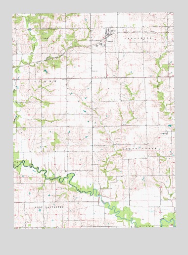
Harper, IA USGS Topographic Map
Click on map above to begin viewing in our Map Viewer.

This topographic map contains these locations and features:
Feature Name Type Latitude Longitude GNIS ID View Map
BadenLocaleN41.3389°W92.0641°466015View Map
Baden CemeteryCemeteryN41.3413°W92.0637°454303View Map
Baden Post Office (historical)Post OfficeN41.3389°W92.0641°1976180View Map
Bethel ChurchChurchN41.3370°W92.0838°454566View Map
Bethel Methodist CemeteryCemeteryN41.3375°W92.0829°1976323View Map
Branch CreekStreamN41.3461°W92.1124°454805View Map
Brater CemeteryCemeteryN41.2583°W92.0918°1976296View Map
City of HarperCivilN41.3637°W92.0510°2394300View Map
Garibaldi CemeteryCemeteryN41.3028°W92.1113°1976322View Map
HarperPopulated PlaceN41.3625°W92.0510°457273View Map
Harper (historical)LocaleN41.3622°W92.0502°1976317View Map
Harper Post OfficePost OfficeN41.3625°W92.0510°1976316View Map
Old Bethel CemeteryCemeteryN41.3333°W92.0835°1976310View Map
Saint Elizabeth SchoolSchoolN41.3586°W92.0524°460974View Map
Saint Elizabeth's CemeteryCemeteryN41.3592°W92.0538°1976318View Map
Saint Elizabeths ChurchChurchN41.3595°W92.0524°1976319View Map
Saints Peter and Paul Catholic CemeteryCemeteryN41.3053°W92.0077°1976321View Map
Saints Peter and Paul ChurchChurchN41.3056°W92.0057°1976320View Map
Saints Peter and Paul SchoolSchoolN41.3050°W92.0060°461352View Map
Township of Clear CreekCivilN41.2942°W92.0050°467617View Map
Township of PlankCivilN41.3555°W92.1202°468522View Map
Warner's Mill Post Office (historical)Post OfficeN41.2695°W92.0557°1976161View Map

Note: Coordinates in the location and feature list above are referenced to NAD83 datum.


Copyright (C) 2008-2024 Ryan Niemi / Sunset Dynamics ... All Rights Reserved