TopoQuest Logo
Do you find TopoQuest useful?
Help keep TopoQuest running and adding new maps/features by donating!
Bitcoin:  19c7KJd3qBynnjoSw5npx9KScwjBe4ifkT
Litecoin:  LXs6TkuXGGXo1vDsWCkWVdjQX94eUKd6ui
Home View Maps Find Maps Find Places Resources & Links


Hartwell Dam, Georgia Topographic Map

USGS Map Title: Hartwell Dam, GA
USGS Map MRC: 34082C7
DRG (GeoTIFF) Download: o34082c7.tif


Neighboring USGS Topographic Map Quads:


  Reed Creek, GA  
34082D8
 

  Hartwell NE, SC  
34082D7
 

  Anderson South, SC  
34082D6
 

  Hartwell, GA  
34082C8
 

  Hartwell Dam, GA  
34082C7
 

  Iva, SC  
34082C6
 

  Dewy Rose, GA  
34082B8
 

  Rock Branch, GA  
34082B7
 

  Lowndesville, SC  
34082B6


Map MRC Location:

N35°
W83°
N35°
W82°
H8 H7 H6 H5 H4 H3 H2 H1
G8 G7 G6 G5 G4 G3 G2 G1
F8 F7 F6 F5 F4 F3 F2 F1
E8 E7 E6 E5 E4 E3 E2 E1
D8 D7 D6 D5 D4 D3 D2 D1
C8 C7 C6 C5 C4 C3 C2 C1
B8 B7 B6 B5 B4 B3 B2 B1
A8 A7 A6 A5 A4 A3 A2 A1
N34°
W83°
N34°
W82°

Hartwell Dam, GA USGS 1:24K Topographic Map Preview:
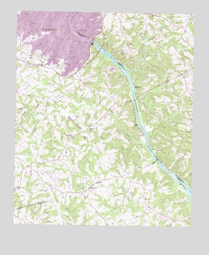
Hartwell Dam, GA USGS Topographic Map
Click on map above to begin viewing in our Map Viewer.

This topographic map contains these locations and features:
Feature Name Type Latitude Longitude GNIS ID View Map
Beulah ChurchChurchN34.2757°W82.8157°354701View Map
Big Generostee CreekStreamN34.3407°W82.7946°1253466View Map
Byers CreekStreamN34.3512°W82.8087°2057023View Map
Cedar CreekStreamN34.2959°W82.7810°355049View Map
Cokesbury CemeteryCemeteryN34.3015°W82.8332°335618View Map
Cokesbury ChurchChurchN34.3018°W82.8337°355227View Map
Cole Dam OneDamN34.3134°W82.8365°338758View Map
Cole Dam ThreeDamN34.3001°W82.8249°338756View Map
Cole Dam TwoDamN34.3118°W82.8349°338760View Map
Cole Lake OneReservoirN34.3129°W82.8367°338759View Map
Cole Lake ThreeReservoirN34.3016°W82.8259°338757View Map
Cole Lake TwoReservoirN34.3116°W82.8345°338761View Map
Cooley School (historical)SchoolN34.2615°W82.7799°352308View Map
Cordell Mill (historical)LocaleN34.3009°W82.8118°335621View Map
Derritt IslandIslandN34.3409°W82.8004°355480View Map
Dooleys Ferry (historical)CrossingN34.3623°W82.8304°335625View Map
Dooleys Ferry (historical)CrossingN34.3623°W82.8304°1236659View Map
Flat Rock CemeteryCemeteryN34.2707°W82.8718°335630View Map
Flat Rock ChurchChurchN34.2709°W82.8724°355830View Map
Gaines ChapelChurchN34.2890°W82.8440°335635View Map
Gaines Chapel CemeteryCemeteryN34.2887°W82.8440°335636View Map
Generostee Baptist ChurchChurchN34.3740°W82.7812°1247885View Map
Greens IslandIslandN34.3096°W82.7874°314868View Map
Grove School (historical)SchoolN34.3315°W82.7543°1236720View Map
Hardscrabble Mills (historical)LocaleN34.3418°W82.7943°1236727View Map
Hart County Fire Department Station 6 Nancy HartBuildingN34.2820°W82.8690°2604438View Map
Hartwell DamDamN34.3582°W82.8207°1223074View Map
Hartwell DamDamN34.3572°W82.8216°315219View Map
Hartwell DamDamN34.3568°W82.8215°338537View Map
Hewin IslandIslandN34.3393°W82.7949°335659View Map
Little Cedar CreekStreamN34.2993°W82.7887°316987View Map
Little Cedar CreekStreamN34.3209°W82.8290°316990View Map
Louis Morris Memorial BridgeBridgeN34.3534°W82.8157°335663View Map
Louis Morris Memorial BridgeBridgeN34.3534°W82.8157°1252221View Map
Lucas CreekStreamN34.3479°W82.7910°1236800View Map
McLaughlin LakeReservoirN34.2598°W82.8380°339474View Map
McLaughlin Lake DamDamN34.2601°W82.8365°339473View Map
McMullins Mill (historical)LocaleN34.3307°W82.8449°335667View Map
Monteideo (historical)Populated PlaceN34.3376°W82.8443°350755View Map
MontevideoPopulated PlaceN34.2723°W82.8218°332409View Map
Mount Hebron Church (historical)ChurchN34.2504°W82.8612°347881View Map
Mount View School (historical)SchoolN34.3073°W82.7526°1236838View Map
Mountain View CemeteryCemeteryN34.3062°W82.7526°1224862View Map
Oak Grove Associate Reformed Presbyterian Church (historical)ChurchN34.3409°W82.7549°1236868View Map
Parks Ferry (historical)CrossingN34.3243°W82.7912°335685View Map
Parks Ferry (historical)CrossingN34.3243°W82.7912°1233415View Map
Poplar Spring CemeteryCemeteryN34.3123°W82.7501°1225629View Map
Sadlers Ferry (historical)CrossingN34.3076°W82.7849°335699View Map
Sadlers Ferry (historical)CrossingN34.3076°W82.7849°1233466View Map
Saint James CemeteryCemeteryN34.3057°W82.8218°335700View Map
Saint James ChurchChurchN34.3059°W82.8221°322094View Map
Sardis CemeteryCemeteryN34.3426°W82.8565°335704View Map
Sardis ChurchChurchN34.3437°W82.8563°322558View Map
Seb Craft IslandIslandN34.2743°W82.7565°322685View Map
Smith-McGee BridgeBridgeN34.3243°W82.7912°335710View Map
Smith-McGee BridgeBridgeN34.3243°W82.7912°1233489View Map
Stephenson IslandIslandN34.3318°W82.7918°323582View Map
Weems CreekStreamN34.3562°W82.7843°1251350View Map

Note: Coordinates in the location and feature list above are referenced to NAD83 datum.


Copyright (C) 2008-2024 Ryan Niemi / Sunset Dynamics ... All Rights Reserved