TopoQuest Logo
Do you find TopoQuest useful?
Help keep TopoQuest running and adding new maps/features by donating!
Bitcoin:  19c7KJd3qBynnjoSw5npx9KScwjBe4ifkT
Litecoin:  LXs6TkuXGGXo1vDsWCkWVdjQX94eUKd6ui
Home View Maps Find Maps Find Places Resources & Links


Hasty, Colorado Topographic Map

USGS Map Title: Hasty, CO
USGS Map MRC: 38102A8
DRG (GeoTIFF) Download: o38102a8.tif


Neighboring USGS Topographic Map Quads:


  Tree Top Ranch, CO  
38103B1
 

  Lubers, CO  
38102B8
 

  McClave, CO  
38102B7
 

  Kreybill, CO  
38103A1
 

  Hasty, CO  
38102A8
 

  Prowers, CO  
38102A7
 

  Toonerville NE, CO  
37103H1
 

  High Rock, CO  
37102H8
 

  Denny Lake, CO  
37102H7


Map MRC Location:

N39°
W103°
N39°
W102°
H8 H7 H6 H5 H4 H3 H2 H1
G8 G7 G6 G5 G4 G3 G2 G1
F8 F7 F6 F5 F4 F3 F2 F1
E8 E7 E6 E5 E4 E3 E2 E1
D8 D7 D6 D5 D4 D3 D2 D1
C8 C7 C6 C5 C4 C3 C2 C1
B8 B7 B6 B5 B4 B3 B2 B1
A8 A7 A6 A5 A4 A3 A2 A1
N38°
W103°
N38°
W102°

Hasty, CO USGS 1:24K Topographic Map Preview:
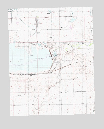
Hasty, CO USGS Topographic Map
Click on map above to begin viewing in our Map Viewer.

This topographic map contains these locations and features:
Feature Name Type Latitude Longitude GNIS ID View Map
CaddoaPopulated PlaceN38.0478°W102.9660°195550View Map
Caddoa CreekStreamN38.0770°W102.9041°195668View Map
Dingwall Ditch Retention DamDamN38.1000°W102.9105°199508View Map
Dingwall Ditch Retention ReservoirReservoirN38.1017°W102.9082°199509View Map
Friends Community Church of HastyChurchN38.1102°W102.9596°2696412View Map
G W Verhoeff DamDamN38.1083°W102.9088°199552View Map
G W Verhoeff ReservoirReservoirN38.1101°W102.9045°199553View Map
HastyPopulated PlaceN38.1125°W102.9574°195541View Map
Hasty - McClave Fire DepartmentBuildingN38.1028°W102.9574°2667157View Map
Hasty Census Designated PlaceCensusN38.1066°W102.9562°2583243View Map
Hasty Post OfficePost OfficeN38.1134°W102.9576°2750881View Map
John Martin Reservoir DamDamN38.0667°W102.9371°200463View Map
KNIC-FM (Lamar)TowerN38.1122°W102.9608°204160View Map
Lake HastyReservoirN38.0709°W102.9321°195551View Map
Levere DitchCanalN38.1128°W102.9296°195545View Map
Prowers ArroyoStreamN38.0833°W102.8885°195417View Map
Union Valley CemeteryCemeteryN38.0961°W102.9580°195542View Map
Verhoeff Catchment DamDamN38.1220°W102.9374°195544View Map
Verhoeff DamDamN38.1075°W102.9080°195547View Map
Verhoeff DitchCanalN38.1039°W102.9102°195548View Map
Verhoeff SpringSpringN38.0901°W102.9390°195546View Map

Note: Coordinates in the location and feature list above are referenced to NAD83 datum.


Copyright (C) 2008-2025 Ryan Niemi / Sunset Dynamics ... All Rights Reserved