TopoQuest Logo
Do you find TopoQuest useful?
Help keep TopoQuest running and adding new maps/features by donating!
Bitcoin:  19c7KJd3qBynnjoSw5npx9KScwjBe4ifkT
Litecoin:  LXs6TkuXGGXo1vDsWCkWVdjQX94eUKd6ui
Home View Maps Find Maps Find Places Resources & Links


Hatteras, North Carolina Topographic Map

USGS Map Title: Hatteras, NC
USGS Map MRC: 35075B6
DRG (GeoTIFF) Download: o35075b6.tif


Neighboring USGS Topographic Map Quads:


  Hatteras, NC  
35075B6


Map MRC Location:

N36°
W76°
N36°
W75°
H8 H7 H6 H5 H4 H3 H2 H1
G8 G7 G6 G5 G4 G3 G2 G1
F8 F7 F6 F5 F4 F3 F2 F1
E8 E7 E6 E5 E4 E3 E2 E1
D8 D7 D6 D5 D4 D3 D2 D1
C8 C7 C6 C5 C4 C3 C2 C1
B8 B7 B6 B5 B4 B3 B2 B1
A8 A7 A6 A5 A4 A3 A2 A1
N35°
W76°
N35°
W75°

Hatteras, NC USGS 1:24K Topographic Map Preview:
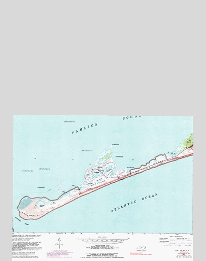
Hatteras, NC USGS Topographic Map
Click on map above to begin viewing in our Map Viewer.

This topographic map contains these locations and features:
Feature Name Type Latitude Longitude GNIS ID View Map
Austin CreekStreamN35.2096°W75.7038°980373View Map
Austin ReefBarN35.2224°W75.7479°997819View Map
Bare HillSummitN35.2180°W75.6649°1002383View Map
Barney Slue BeaconLocaleN35.2193°W75.7313°980579View Map
Bird IslandsIslandN35.2988°W75.6621°981501View Map
Birds IslandIslandN35.2991°W75.6632°1008314View Map
Clam ShoalBarN35.2988°W75.6488°1002381View Map
Coast Guard Station Hatteras InletMilitaryN35.2079°W75.7029°2512110View Map
Cross Shoal BeaconLocaleN35.2182°W75.7357°983790View Map
Dare County Sheriff's District OfficeBuildingN35.2193°W75.6907°2130869View Map
Duck PondsLakeN35.2129°W75.6900°984389View Map
Duncan PointCapeN35.2202°W75.6707°984424View Map
Durant PointCapeN35.2327°W75.6810°984443View Map
Egg ShoalBarN35.2571°W75.7135°1018657View Map
Fort Clark (historical)LocaleN35.1971°W75.7318°1020327View Map
Fort HatterasLocaleN35.1910°W75.7324°1023374View Map
Fort Totten (historical)MilitaryN35.2133°W75.6792°1018658View Map
FriscoPopulated PlaceN35.2352°W75.6285°1020367View Map
Frisco Census Designated PlaceCensusN35.2332°W75.6289°2628626View Map
Frisco LightLocaleN35.2641°W75.6315°1008354View Map
Frisco Post OfficePost OfficeN35.2341°W75.6252°2774077View Map
Goose CreekStreamN35.2060°W75.7113°985819View Map
HatterasPopulated PlaceN35.2193°W75.6902°1020636View Map
Hatteras Census Designated PlaceCensusN35.2194°W75.6876°2628633View Map
Hatteras Fire DepartmentBuildingN35.2191°W75.6905°2638060View Map
Hatteras Inlet LightLocaleN35.1927°W75.7368°1008353View Map
Hatteras Inlet LightLocaleN35.2088°W75.7324°986496View Map
Hatteras Island Free FerryLocaleN35.2027°W75.7493°1024913View Map
Hatteras Post OfficePost OfficeN35.2189°W75.6901°2774347View Map
Inlet PeninsulaCapeN35.1935°W75.7418°987383View Map
Isaac PondsLakeN35.2108°W75.6962°987411View Map
Isabel Breach (historical)GutN35.2003°W75.7161°2353138View Map
Isabel Inlet (historical)GutN35.2267°W75.6375°2353119View Map
Joe Saur CreekStreamN35.2288°W75.6410°987628View Map
Little Hatteras Island (historical)IslandN35.2121°W75.6852°2353139View Map
Log ShoalBarN35.2893°W75.6754°1008349View Map
Old Rollinson ChannelChannelN35.2543°W75.6829°997817View Map
Oliver ReefBarN35.2446°W75.7427°1004638View Map
Rawlinsons ChannelChannelN35.2641°W75.7066°1018648View Map
Rollinson Channel BeaconLocaleN35.2299°W75.7018°993663View Map
Rollinson Channel LightLocaleN35.2463°W75.7141°993664View Map
Rollinson Channel LightLocaleN35.2574°W75.7216°993665View Map
Sandy BayBayN35.2260°W75.6793°994250View Map
Shark ShoalBarN35.2593°W75.7174°1008355View Map
The SlashGutN35.2196°W75.6827°996010View Map

Note: Coordinates in the location and feature list above are referenced to NAD83 datum.


Copyright (C) 2008-2024 Ryan Niemi / Sunset Dynamics ... All Rights Reserved