TopoQuest Logo
Do you find TopoQuest useful?
Help keep TopoQuest running and adding new maps/features by donating!
Bitcoin:  19c7KJd3qBynnjoSw5npx9KScwjBe4ifkT
Litecoin:  LXs6TkuXGGXo1vDsWCkWVdjQX94eUKd6ui
Home View Maps Find Maps Find Places Resources & Links


Hayters Gap, Virginia Topographic Map

USGS Map Title: Hayters Gap, VA
USGS Map MRC: 36081G8
DRG (GeoTIFF) Download: o36081g8.tif


Neighboring USGS Topographic Map Quads:


  Lebanon, VA  
36082H1
 

  Elk Garden, VA  
36081H8
 

  Saltville, VA  
36081H7
 

  Brumley, VA  
36082G1
 

  Hayters Gap, VA  
36081G8
 

  Glade Spring, VA  
36081G7
 

  Wyndale, VA  
36082F1
 

  Abingdon, VA  
36081F8
 

  Damascus, VA  
36081F7


Map MRC Location:

N37°
W82°
N37°
W81°
H8 H7 H6 H5 H4 H3 H2 H1
G8 G7 G6 G5 G4 G3 G2 G1
F8 F7 F6 F5 F4 F3 F2 F1
E8 E7 E6 E5 E4 E3 E2 E1
D8 D7 D6 D5 D4 D3 D2 D1
C8 C7 C6 C5 C4 C3 C2 C1
B8 B7 B6 B5 B4 B3 B2 B1
A8 A7 A6 A5 A4 A3 A2 A1
N36°
W82°
N36°
W81°

Hayters Gap, VA USGS 1:24K Topographic Map Preview:
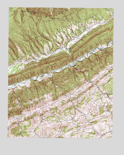
Hayters Gap, VA USGS Topographic Map
Click on map above to begin viewing in our Map Viewer.

This topographic map contains these locations and features:
Feature Name Type Latitude Longitude GNIS ID View Map
Barnett HollowValleyN36.8362°W81.9346°1481467View Map
Beetree BranchStreamN36.8498°W81.9098°1463012View Map
Bethany ChurchChurchN36.7848°W81.9382°1481649View Map
Bethany CreekStreamN36.8018°W81.9440°1481654View Map
Braudy BranchStreamN36.8198°W81.9279°1481974View Map
Brumley RidgeRidgeN36.8687°W81.9937°1482052View Map
Casey BranchStreamN36.8265°W81.9593°1498235View Map
Casey HollowValleyN36.8265°W81.9638°1482361View Map
Chestnut RidgeRidgeN36.8037°W81.8815°1482505View Map
Clinch Mountain Volunteer Fire DepartmentBuildingN36.8368°W81.9355°2721067View Map
Cooley Camp BranchStreamN36.8293°W81.9496°1482692View Map
Count CreekStreamN36.7929°W81.9929°1482722View Map
Dry BranchStreamN36.8232°W81.9746°1483092View Map
Duncan School (historical)SchoolN36.8240°W81.9801°1498251View Map
DuncanvillePopulated PlaceN36.8234°W81.9885°1495483View Map
East Fork Wolf CreekStreamN36.8343°W81.9285°1483213View Map
Edington BranchStreamN36.8304°W81.9462°1483242View Map
Edington CoveValleyN36.8492°W81.9610°1483243View Map
Finley CreekStreamN36.8084°W81.9485°1483417View Map
Fullen BranchStreamN36.8276°W81.9048°1483556View Map
Giesley MillPopulated PlaceN36.7796°W81.8815°1495589View Map
GlenfordPopulated PlaceN36.7901°W81.9296°1495594View Map
Glenford Church (historical)ChurchN36.7921°W81.9232°1498262View Map
Gobble BranchStreamN36.8059°W81.9737°1483679View Map
Greenway BranchStreamN36.7557°W81.8935°1483826View Map
Hayters GapGapN36.8648°W81.9462°1483997View Map
Hayters GapPopulated PlaceN36.8357°W81.9287°1483998View Map
Hayters Gap SchoolSchoolN36.8337°W81.9282°1498273View Map
Helton HollowValleyN36.8059°W81.9643°1484021View Map
Henderson School (historical)SchoolN36.8604°W81.8862°1498275View Map
Holt HollowValleyN36.8333°W81.9271°1484170View Map
Hurley HollowValleyN36.8439°W81.9264°1484293View Map
Jamison CemeteryCemeteryN36.8145°W81.9385°1484398View Map
Jefferson DistrictCivilN36.8128°W81.9535°1927361View Map
Lee CreekStreamN36.8115°W81.9965°1484756View Map
Lee HollowValleyN36.8214°W81.9909°1484758View Map
LindellPopulated PlaceN36.8046°W81.9007°1495843View Map
Little MountainRangeN36.8171°W81.9640°1487053View Map
Logan CreekStreamN36.8182°W81.9207°1485030View Map
LowlandPopulated PlaceN36.7726°W81.9832°1495880View Map
Lowland School (historical)SchoolN36.7729°W81.9773°1498303View Map
Maiden CreekStreamN36.7912°W81.9273°1485158View Map
Maiden Falls School (historical)SchoolN36.7759°W81.9137°1498304View Map
McCray ChapelChurchN36.8559°W81.9037°1485277View Map
McCray Chapel CemeteryCemeteryN36.8558°W81.9043°2774745View Map
Middle KnobSummitN36.8715°W81.9779°1485373View Map
MidwayPopulated PlaceN36.7862°W81.8762°1498312View Map
Mitchell BranchStreamN36.8012°W81.9882°1485497View Map
Morrison CliffCliffN36.8193°W81.9218°1485561View Map
Mountain View ChurchChurchN36.7659°W81.9043°1485698View Map
Mudlick BranchStreamN36.8515°W81.9051°1485748View Map
Oakdale SchoolSchoolN36.7576°W81.9618°1488799View Map
Oakdale School (historical)SchoolN36.7626°W81.9585°1498317View Map
Poston BranchStreamN36.8329°W81.8985°1486384View Map
Price CreekStreamN36.8421°W81.9212°1486427View Map
Price GapGapN36.8721°W81.9343°1486428View Map
Rich Mountain CreekStreamN36.8665°W81.8757°1486588View Map
River Bend School (historical)SchoolN36.8429°W81.8754°1498327View Map
River BridgeLocaleN36.8187°W81.9176°1486632View Map
Scott CoveValleyN36.7735°W81.9727°1486977View Map
Short HollowValleyN36.8480°W81.9379°1487221View Map
ShortsvillePopulated PlaceN36.7723°W81.9076°1496223View Map
Smyth BranchStreamN36.7923°W81.8823°1487353View Map
Taylor BranchStreamN36.8365°W81.8837°1487783View Map
Thompson CemeteryCemeteryN36.8065°W81.9629°1487874View Map
Toole CreekStreamN36.7976°W81.9962°1487954View Map
Turkey HollowValleyN36.8179°W81.9222°1488022View Map
Valley ChurchChurchN36.7737°W81.9485°1488086View Map
Valley Rescue SquadBuildingN36.8337°W81.9292°2721134View Map
Van Hook BranchStreamN36.8487°W81.9104°1488104View Map
Walker PlacePopulated PlaceN36.8537°W81.9068°1498355View Map
Wesley ChapelChurchN36.8071°W81.9718°1488232View Map
Wesley Chapel SchoolSchoolN36.8076°W81.9735°1488850View Map
West Fork Wolf CreekStreamN36.8346°W81.9285°1488258View Map
White MillPopulated PlaceN36.7684°W81.9876°1496402View Map
Whiterock BranchStreamN36.8282°W81.9523°1488331View Map
Whiterock CoveValleyN36.8599°W81.9858°1488332View Map
Williams BranchStreamN36.7926°W81.9785°1488386View Map
Wolf CemeteryCemeteryN36.7815°W81.8921°1488437View Map
Wolf CreekStreamN36.8237°W81.9210°1488439View Map
Wydner HollowValleyN36.8360°W81.9361°1487100View Map
Yellow Spring BranchStreamN36.7934°W81.8873°1487117View Map
Yellow Spring United Methodist ChurchChurchN36.7901°W81.8896°1498375View Map
Yellow SpringsSpringN36.7915°W81.8862°1487119View Map

Note: Coordinates in the location and feature list above are referenced to NAD83 datum.


Copyright (C) 2008-2025 Ryan Niemi / Sunset Dynamics ... All Rights Reserved