TopoQuest Logo
Do you find TopoQuest useful?
Help keep TopoQuest running and adding new maps/features by donating!
Bitcoin:  19c7KJd3qBynnjoSw5npx9KScwjBe4ifkT
Litecoin:  LXs6TkuXGGXo1vDsWCkWVdjQX94eUKd6ui
Home View Maps Find Maps Find Places Resources & Links


Hazelwood, North Carolina Topographic Map

USGS Map Title: Hazelwood, NC
USGS Map MRC: 35083D1
DRG (GeoTIFF) Download: o35083d1.tif


Neighboring USGS Topographic Map Quads:


  Bunches Bald, NC  
35083E2
 

  Dellwood, NC  
35083E1
 

  Clyde, NC  
35082E8
 

  Sylva North, NC  
35083D2
 

  Hazelwood, NC  
35083D1
 

  Waynesville, NC  
35082D8
 

  Sylva South, NC  
35083C2
 

  Tuckasegee, NC  
35083C1
 

  Sam Knob, NC  
35082C8


Map MRC Location:

N36°
W84°
N36°
W83°
H8 H7 H6 H5 H4 H3 H2 H1
G8 G7 G6 G5 G4 G3 G2 G1
F8 F7 F6 F5 F4 F3 F2 F1
E8 E7 E6 E5 E4 E3 E2 E1
D8 D7 D6 D5 D4 D3 D2 D1
C8 C7 C6 C5 C4 C3 C2 C1
B8 B7 B6 B5 B4 B3 B2 B1
A8 A7 A6 A5 A4 A3 A2 A1
N35°
W84°
N35°
W83°

Hazelwood, NC USGS 1:24K Topographic Map Preview:
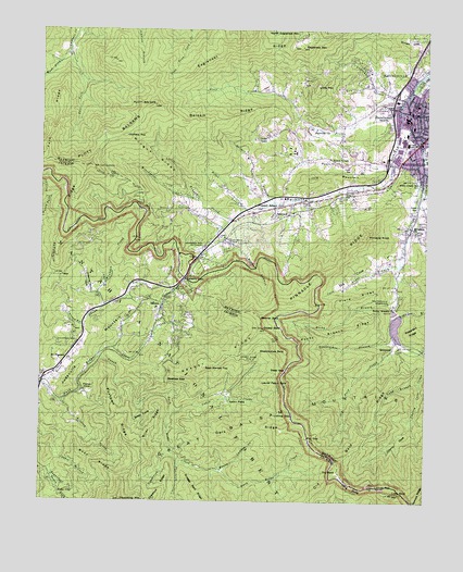
Hazelwood, NC USGS Topographic Map
Click on map above to begin viewing in our Map Viewer.

This topographic map contains these locations and features:
Feature Name Type Latitude Longitude GNIS ID View Map
Allen CreekStreamN35.4701°W83.0090°1008682View Map
Allens Creek Elementary SchoolSchoolN35.4607°W83.0018°1008683View Map
BalsamPopulated PlaceN35.4268°W83.0851°1018943View Map
Balsam - Willets - Ochre Hill Volunteer Fire Department Station 1BuildingN35.4118°W83.1149°2639551View Map
Balsam - Willets - Ochre Hill Volunteer Fire Department Station 2BuildingN35.4269°W83.1041°2638265View Map
Balsam GapGapN35.4340°W83.0776°1008907View Map
Balsam Post OfficePost OfficeN35.4296°W83.0833°2766577View Map
Balsam RidgeRidgeN35.4759°W83.0690°1008909View Map
Bearpen BranchStreamN35.4248°W83.0090°1009021View Map
Beef Market TopSummitN35.4107°W83.0710°1019058View Map
Beetree GapGapN35.4070°W83.0835°1009152View Map
Big CoveValleyN35.4381°W83.0097°1009290View Map
Boar RidgeRidgeN35.3851°W83.1065°1009507View Map
Brier CoveValleyN35.3994°W83.0918°1009601View Map
Brier RidgeRidgeN35.3940°W83.0879°1009602View Map
Browning BranchStreamN35.4787°W83.0076°1009665View Map
Cabin CreekStreamN35.3993°W83.0815°1009882View Map
Cabin FlatsFlatN35.4018°W83.0640°1009884View Map
Camp BranchStreamN35.4665°W83.0004°1009940View Map
Carson BranchStreamN35.4215°W83.1101°1010058View Map
Cherry CoveValleyN35.3970°W83.0049°1010206View Map
Chestnut RidgeRidgeN35.3782°W83.0849°1010265View Map
Chewing Gum CoveValleyN35.4301°W83.1082°1010272View Map
ClarkPopulated PlaceN35.4404°W83.0738°1019682View Map
Cove Field BranchStreamN35.4384°W83.0093°1010508View Map
Cove Field RidgeRidgeN35.4295°W83.0262°1010509View Map
Crawford CemeteryCemeteryN35.4173°W83.1126°1010573View Map
Cut-Off RidgeRidgeN35.4357°W83.1226°1010629View Map
Dark RidgeRidgeN35.3945°W83.0560°1010658View Map
Dark Ridge CreekStreamN35.4062°W83.1232°1010660View Map
Deep GapGapN35.4101°W83.0451°1010746View Map
Doubletop CreekStreamN35.3887°W83.0821°1010889View Map
Doubletop MountainSummitN35.3754°W83.0976°1010892View Map
Drift BranchStreamN35.4545°W83.0490°1010903View Map
Eaglenest (historical)Populated PlaceN35.4973°W83.0432°1960039View Map
Eaglenest CreekStreamN35.4820°W83.0074°1010965View Map
Eaglenest MountainSummitN35.4962°W83.0432°1010966View Map
Eaglenest RidgeRidgeN35.4945°W83.0624°1010967View Map
East Fork Campbell CreekStreamN35.4943°W83.1160°1010981View Map
Fairview ChurchChurchN35.4743°W83.0357°1011135View Map
Farmer BranchStreamN35.4840°W83.0046°1011182View Map
Fisher CoveValleyN35.4043°W83.1103°1011230View Map
Flat GapGapN35.3920°W83.0376°1011260View Map
Flint Spring CreekStreamN35.3854°W83.0796°1011291View Map
Fork RidgeRidgeN35.4665°W83.1221°1011333View Map
Fowler Balsam MountainSummitN35.4754°W83.0788°1008623View Map
Foxtown RidgeRidgeN35.3984°W83.0996°1011365View Map
Grassy BaldSummitN35.4215°W83.0529°1011618View Map
Grassy RidgeRidgeN35.4132°W83.0649°1011653View Map
Grassy Ridge MineMineN35.4132°W83.0554°1011660View Map
Haywood County Emergency Medical Services - Medic 1 and Medic 5BuildingN35.4729°W83.0048°2720555View Map
Haywood County Sheriff's OfficeBuildingN35.4714°W83.0056°2769572View Map
HazelwoodPopulated PlaceN35.4687°W83.0040°1011949View Map
Hazelwood Post OfficePost OfficeN35.4780°W83.0017°2766601View Map
Hazelwood Shopping CenterLocaleN35.4495°W83.0043°1017770View Map
Hyatt CreekPopulated PlaceN35.4654°W83.0285°1020871View Map
Hyatt CreekStreamN35.4662°W83.0112°1012320View Map
Hyatt Creek Freewill Baptist ChurchChurchN35.4679°W83.0274°1960040View Map
Jones CreekStreamN35.4134°W83.1054°1012555View Map
Judaculla MountainSummitN35.4237°W83.1021°1020994View Map
Laurel Patch BaldSummitN35.4070°W83.0426°1021117View Map
Licklog CreekStreamN35.4012°W83.1165°1012855View Map
Licklog GapGapN35.3979°W83.0429°1012860View Map
Little BranchStreamN35.4551°W83.0732°1012915View Map
Little MountainSummitN35.4607°W83.0365°1021212View Map
Little MountainSummitN35.4851°W83.0360°1021213View Map
Locust GapGapN35.3790°W83.0160°1013059View Map
Lone BaldSummitN35.3773°W83.0096°1013086View Map
Long BranchStreamN35.4068°W83.0015°1013110View Map
Long SwagRidgeN35.3790°W83.0229°1013178View Map
Love CemeteryCemeteryN35.4079°W83.1240°1013208View Map
Micadale ChurchChurchN35.4479°W83.0043°1013483View Map
Mingus RidgeRidgeN35.4662°W83.0885°1013618View Map
Morrison Fish HatcheryLocaleN35.4426°W83.0726°1013706View Map
Mount Lyn LowrySummitN35.4640°W83.1104°1023665View Map
Mount Pleasant ChurchChurchN35.4120°W83.1146°1013763View Map
Nolen CreekStreamN35.4520°W83.0582°1013973View Map
Old BaldSummitN35.3832°W83.0276°1021727View Map
Old Bald CreekStreamN35.4187°W83.0090°1014087View Map
Oldfield TopSummitN35.4720°W83.0974°1021741View Map
Oxear CoveValleyN35.4713°W83.0515°1014165View Map
Pinnacle KnobSummitN35.4459°W83.0185°1021983View Map
Pinnacle RidgeRidgeN35.4390°W83.0274°1014473View Map
Pinnacle Ridge TunnelTunnelN35.4351°W83.0343°2035917View Map
Pleasant Balsam Baptist ChurchChurchN35.4540°W83.0468°1014507View Map
Plott BalsamSummitN35.4804°W83.0882°1014536View Map
Plott CemeteryCemeteryN35.4537°W83.0399°1014538View Map
Plott CreekStreamN35.4804°W83.0082°1014539View Map
Queen Camp CreekStreamN35.3826°W83.0660°1014682View Map
QuinlandPopulated PlaceN35.4162°W83.0101°1022127View Map
Redbank BranchStreamN35.4479°W83.0665°1014791View Map
Redbank CemeteryCemeteryN35.4443°W83.0632°1014792View Map
Rocky BranchStreamN35.4304°W83.0087°1015021View Map
Rocky Branch CemeteryCemeteryN35.4273°W83.0107°1960044View Map
Rocky Branch ChurchChurchN35.4276°W83.0101°1015027View Map
Rocky Branch RidgeRidgeN35.4207°W83.0279°1015028View Map
Ruby CityPopulated PlaceN35.3773°W83.1182°1022439View Map
SaunookPopulated PlaceN35.4518°W83.0446°1022513View Map
Saunook Volunteer Fire DepartmentBuildingN35.4520°W83.0562°2639103View Map
Snaggy Bald RidgeRidgeN35.3751°W83.0713°1015622View Map
South Fork Sugarloaf CreekStreamN35.3826°W83.1210°1015697View Map
Steestachee BaldSummitN35.4157°W83.0451°1022787View Map
Steestachee BranchStreamN35.4198°W83.0104°1015811View Map
Township of Scott CreekCivilN35.4100°W83.1092°1026840View Map
Township of WaynesvilleCivilN35.4626°W83.0056°1026784View Map
Waynesville Fire Department Station 2BuildingN35.4815°W83.0024°2638783View Map
Waynesville ReservoirReservoirN35.4280°W83.0122°1016483View Map
Waynesville Water Supply DamDamN35.4282°W83.0118°1017200View Map
Wesner BaldSummitN35.4243°W83.0535°1023158View Map
West Fork Campbell CreekStreamN35.4943°W83.1160°1016533View Map
Winchester CreekStreamN35.4501°W83.0629°1016739View Map
Woodfin CreekStreamN35.4259°W83.1043°1016809View Map
Woodfin FallsFallsN35.4515°W83.0943°1023603View Map

Note: Coordinates in the location and feature list above are referenced to NAD83 datum.


Copyright (C) 2008-2025 Ryan Niemi / Sunset Dynamics ... All Rights Reserved