TopoQuest Logo
Do you find TopoQuest useful?
Help keep TopoQuest running and adding new maps/features by donating!
Bitcoin:  19c7KJd3qBynnjoSw5npx9KScwjBe4ifkT
Litecoin:  LXs6TkuXGGXo1vDsWCkWVdjQX94eUKd6ui
Home View Maps Find Maps Find Places Resources & Links


Ayden, North Carolina Topographic Map

USGS Map Title: Ayden, NC
USGS Map MRC: 35077D4
DRG (GeoTIFF) Download: o35077d4.tif


Neighboring USGS Topographic Map Quads:


  Farmville, NC  
35077E5
 

  Greenville SW, NC  
35077E4
 

  Greenville SE, NC  
35077E3
 

  Hookerton, NC  
35077D5
 

  Ayden, NC  
35077D4
 

  Gardnerville, NC  
35077D3
 

  Kinston, NC  
35077C5
 

  Grifton, NC  
35077C4
 

  Fort Barnwell, NC  
35077C3


Map MRC Location:

N36°
W78°
N36°
W77°
H8 H7 H6 H5 H4 H3 H2 H1
G8 G7 G6 G5 G4 G3 G2 G1
F8 F7 F6 F5 F4 F3 F2 F1
E8 E7 E6 E5 E4 E3 E2 E1
D8 D7 D6 D5 D4 D3 D2 D1
C8 C7 C6 C5 C4 C3 C2 C1
B8 B7 B6 B5 B4 B3 B2 B1
A8 A7 A6 A5 A4 A3 A2 A1
N35°
W78°
N35°
W77°

Ayden, NC USGS 1:24K Topographic Map Preview:
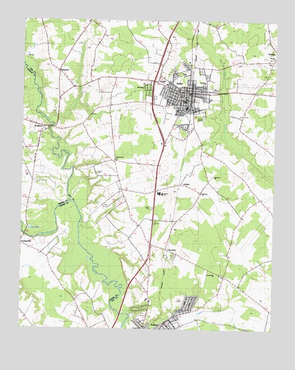
Ayden, NC USGS Topographic Map
Click on map above to begin viewing in our Map Viewer.

This topographic map contains these locations and features:
Feature Name Type Latitude Longitude GNIS ID View Map
Anointed One Church of DeliveranceChurchN35.4675°W77.4068°2506080View Map
Artis CemeteryCemeteryN35.4369°W77.4959°1004431View Map
AydenPopulated PlaceN35.4727°W77.4155°1018886View Map
Ayden Elementary SchoolSchoolN35.4755°W77.4326°1007455View Map
Ayden Fire DepartmentBuildingN35.4724°W77.4166°2638100View Map
Ayden First Pentecostal Holiness ChurchChurchN35.4763°W77.4087°2506085View Map
Ayden Golf and Country ClubLocaleN35.4629°W77.3897°1018741View Map
Ayden Middle SchoolSchoolN35.4752°W77.4318°1004419View Map
Ayden Police DepartmentBuildingN35.4713°W77.4168°2130844View Map
Ayden Post OfficePost OfficeN35.4720°W77.4189°1024974View Map
Ayden Rescue SquadBuildingN35.4725°W77.4166°2720609View Map
Ayden-Grifton High SchoolSchoolN35.4281°W77.4320°1004426View Map
Belair EstatesPopulated PlaceN35.4629°W77.4122°1005860View Map
Britthaven of AydenBuildingN35.4737°W77.4206°2505740View Map
Community ChurchChurchN35.4752°W77.4094°1004421View Map
Cresent Heights Mobile Home ParkPopulated PlaceN35.4043°W77.4243°2505446View Map
DeerfieldPopulated PlaceN35.4721°W77.4061°1005861View Map
Edwards BridgeLocaleN35.4132°W77.4966°984652View Map
Elm Grove ChurchChurchN35.4371°W77.4047°1004427View Map
Elm Grove ChurchChurchN35.4304°W77.4102°1004428View Map
Faith Baptist ChurchChurchN35.4151°W77.4354°2505808View Map
Grifton Police Department Non EmergencyBuildingN35.3754°W77.4389°2130980View Map
Hancock ChurchChurchN35.4852°W77.3755°1004423View Map
HanrahanPopulated PlaceN35.4071°W77.4272°1006229View Map
Jackson CemeteryCemeteryN35.4383°W77.4627°1004424View Map
Jumping Run ChurchChurchN35.3979°W77.4036°1004432View Map
Kennedy EstatesPopulated PlaceN35.4579°W77.4205°1005859View Map
Liberty ChurchChurchN35.4682°W77.4083°1004422View Map
Little Contentnea CreekStreamN35.4268°W77.4783°1024091View Map
Little Creek ChurchChurchN35.4563°W77.4886°1004430View Map
LittlefieldPopulated PlaceN35.4343°W77.4216°1021247View Map
New Deliverance Free Will Baptist ChurchChurchN35.4703°W77.4168°2506116View Map
North Hills EstatesPopulated PlaceN35.4821°W77.4197°1005863View Map
Open Heart Church of GodChurchN35.4832°W77.4313°2506209View Map
Pleasant Plains ChurchChurchN35.4438°W77.4533°1004425View Map
Pleasant RidgePopulated PlaceN35.4177°W77.4330°1005858View Map
RedalliaPopulated PlaceN35.4849°W77.3764°1022200View Map
RountreePopulated PlaceN35.4804°W77.4800°1027454View Map
Saint Jude ChurchChurchN35.3757°W77.4397°1004429View Map
ScuffletonPopulated PlaceN35.4568°W77.4880°993336View Map
Strawberry BanksPopulated PlaceN35.4785°W77.4097°1005862View Map
The PinesPopulated PlaceN35.4724°W77.4386°1004418View Map
Town of AydenCivilN35.4694°W77.4167°2405193View Map
Township of AydenCivilN35.4683°W77.4349°1027054View Map
Township of GriftonCivilN35.3878°W77.3863°1027063View Map
Zion ChapelChurchN35.4677°W77.4205°1004420View Map

Note: Coordinates in the location and feature list above are referenced to NAD83 datum.


Copyright (C) 2008-2024 Ryan Niemi / Sunset Dynamics ... All Rights Reserved