TopoQuest Logo
Do you find TopoQuest useful?
Help keep TopoQuest running and adding new maps/features by donating!
Bitcoin:  19c7KJd3qBynnjoSw5npx9KScwjBe4ifkT
Litecoin:  LXs6TkuXGGXo1vDsWCkWVdjQX94eUKd6ui
Home View Maps Find Maps Find Places Resources & Links


Helendale, California Topographic Map

USGS Map Title: Helendale, CA
USGS Map MRC: 34117F3
DRG (GeoTIFF) Download: o34117f3.tif


Neighboring USGS Topographic Map Quads:


  Astley Rancho, CA  
34117G4
 

  Wild Crossing, CA  
34117G3
 

  Hodge, CA  
34117G2
 

  Victorville NW, CA  
34117F4
 

  Helendale, CA  
34117F3
 

  Turtle Valley, CA  
34117F2
 

  Adelanto, CA  
34117E4
 

  Victorville, CA  
34117E3
 

  Apple Valley North, CA  
34117E2


Map MRC Location:

N35°
W118°
N35°
W117°
H8 H7 H6 H5 H4 H3 H2 H1
G8 G7 G6 G5 G4 G3 G2 G1
F8 F7 F6 F5 F4 F3 F2 F1
E8 E7 E6 E5 E4 E3 E2 E1
D8 D7 D6 D5 D4 D3 D2 D1
C8 C7 C6 C5 C4 C3 C2 C1
B8 B7 B6 B5 B4 B3 B2 B1
A8 A7 A6 A5 A4 A3 A2 A1
N34°
W118°
N34°
W117°

Helendale, CA USGS 1:24K Topographic Map Preview:
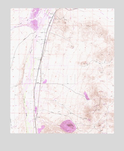
Helendale, CA USGS Topographic Map
Click on map above to begin viewing in our Map Viewer.

This topographic map contains these locations and features:
Feature Name Type Latitude Longitude GNIS ID View Map
Airway Beacon 8LocaleN34.7355°W117.3117°1654535View Map
Apex MineMineN34.6480°W117.2689°238665View Map
Branch MineMineN34.6528°W117.2731°239649View Map
BrymanPopulated PlaceN34.6747°W117.3456°252861View Map
Fremont WashStreamN34.7386°W117.3387°271223View Map
HelendalePopulated PlaceN34.7439°W117.3245°243339View Map
Helendale Elementary SchoolSchoolN34.7478°W117.3353°1841542View Map
Helendale Post OfficePost OfficeN34.7434°W117.3355°1841543View Map
La DeltaPopulated PlaceN34.6422°W117.3445°1660853View Map
Las Cruces Ranch (historical)LocaleN34.7472°W117.3475°1841545View Map
North LakeReservoirN34.7464°W117.3437°1841547View Map
North LakeReservoirN34.7491°W117.3441°246642View Map
Oro Grande MineMineN34.6542°W117.2639°246974View Map
Palisades Ranch AirportAirportN34.7166°W117.3482°1653517View Map
Riverview Middle SchoolSchoolN34.7408°W117.3292°1841551View Map
San Bernardino County Fire Department Station 4 - Silver Lakes / HelendaleBuildingN34.7437°W117.3345°2665058View Map
Silver LakesPopulated PlaceN34.7456°W117.3410°2652388View Map
Silver MountainSummitN34.6514°W117.2673°249482View Map
South LakeReservoirN34.7350°W117.3464°1841554View Map
Sparkhule MountainSummitN34.6319°W117.3009°1661486View Map
Western States MineMineN34.6436°W117.2606°1841559View Map

Note: Coordinates in the location and feature list above are referenced to NAD83 datum.


Copyright (C) 2008-2024 Ryan Niemi / Sunset Dynamics ... All Rights Reserved