TopoQuest Logo
Do you find TopoQuest useful?
Help keep TopoQuest running and adding new maps/features by donating!
Bitcoin:  19c7KJd3qBynnjoSw5npx9KScwjBe4ifkT
Litecoin:  LXs6TkuXGGXo1vDsWCkWVdjQX94eUKd6ui
Home View Maps Find Maps Find Places Resources & Links


Henry, Idaho Topographic Map

USGS Map Title: Henry, ID
USGS Map MRC: 42111H5
DRG (GeoTIFF) Download: o42111h5.tif


Neighboring USGS Topographic Map Quads:


  Meadow Creek Mountain, ID  
43111A6
 

  Little Valley Hills, ID  
43111A5
 

  Bear Island, ID  
43111A4
 

  Reservoir Mountain, ID  
42111H6
 

  Henry, ID  
42111H5
 

  Wayan West, ID  
42111H4
 

  The Dip, ID  
42111G6
 

  China Hat, ID  
42111G5
 

  Lower Valley, ID  
42111G4


Map MRC Location:

N43°
W112°
N43°
W111°
H8 H7 H6 H5 H4 H3 H2 H1
G8 G7 G6 G5 G4 G3 G2 G1
F8 F7 F6 F5 F4 F3 F2 F1
E8 E7 E6 E5 E4 E3 E2 E1
D8 D7 D6 D5 D4 D3 D2 D1
C8 C7 C6 C5 C4 C3 C2 C1
B8 B7 B6 B5 B4 B3 B2 B1
A8 A7 A6 A5 A4 A3 A2 A1
N42°
W112°
N42°
W111°

Henry, ID USGS 1:24K Topographic Map Preview:
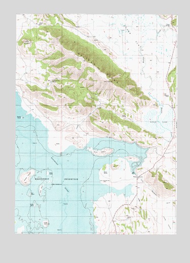
Henry, ID USGS Topographic Map
Click on map above to begin viewing in our Map Viewer.

This topographic map contains these locations and features:
Feature Name Type Latitude Longitude GNIS ID View Map
Blackfoot ReservoirReservoirN42.9146°W111.6089°397452View Map
Buck IslandIslandN42.9216°W111.5588°395142View Map
Camp PeakSummitN42.9633°W111.5508°376065View Map
Chain IslandIslandN42.9096°W111.5999°395194View Map
Chubb FlatFlatN42.9874°W111.5336°395213View Map
Chubb SpringsSpringN42.9951°W111.5054°396284View Map
Cinder IslandIslandN42.8805°W111.6011°395214View Map
Collett CreekStreamN42.9294°W111.5672°395243View Map
Crater MountainSummitN42.9846°W111.6155°372245View Map
Gaston Beatty SpringSpringN42.9624°W111.5967°395414View Map
Goose LakeSwampN42.9402°W111.5070°376434View Map
Gull IslandIslandN42.8977°W111.6136°395439View Map
HenryPopulated PlaceN42.9069°W111.5308°396646View Map
Henry Stampede ParkParkN42.9055°W111.5516°395461View Map
Little Blackfoot RiverStreamN42.9096°W111.5313°384739View Map
Long IslandIslandN42.9005°W111.6052°395647View Map
Long ValleyValleyN42.8896°W111.5002°386097View Map
Meadow CreekStreamN42.9241°W111.5213°373893View Map
Pelican RidgeRidgeN42.9730°W111.5711°374357View Map
Robbers RoostSummitN42.9549°W111.5099°395007View Map
Rosie SpringSpringN42.9419°W111.5425°395015View Map
Sheep IslandIslandN42.9080°W111.6163°395934View Map
Spring IslandIslandN42.9410°W111.6202°395984View Map
Warm SpringSpringN42.9101°W111.5565°375737View Map
Willow IslandIslandN42.8913°W111.6097°399655View Map
Wilson PassGapN42.9935°W111.6030°399662View Map

Note: Coordinates in the location and feature list above are referenced to NAD83 datum.


Copyright (C) 2008-2024 Ryan Niemi / Sunset Dynamics ... All Rights Reserved