TopoQuest Logo
Do you find TopoQuest useful?
Help keep TopoQuest running and adding new maps/features by donating!
Bitcoin:  19c7KJd3qBynnjoSw5npx9KScwjBe4ifkT
Litecoin:  LXs6TkuXGGXo1vDsWCkWVdjQX94eUKd6ui
Home View Maps Find Maps Find Places Resources & Links


Hereford, Texas Topographic Map

USGS Map Title: Hereford, TX
USGS Map MRC: 34102G4
DRG (GeoTIFF) Download: o34102g4.tif


Neighboring USGS Topographic Map Quads:


  Westway NE, TX  
34102H5
 

  Milo Center, TX  
34102H4
 

  Hereford NE, TX  
34102H3
 

  Westway, TX  
34102G5
 

  Hereford, TX  
34102G4
 

  Hereford SE, TX  
34102G3
 

  Summerfield, TX  
34102F5
 

  Easter, TX  
34102F4
 

  Jumbo, TX  
34102F3


Map MRC Location:

N35°
W103°
N35°
W102°
H8 H7 H6 H5 H4 H3 H2 H1
G8 G7 G6 G5 G4 G3 G2 G1
F8 F7 F6 F5 F4 F3 F2 F1
E8 E7 E6 E5 E4 E3 E2 E1
D8 D7 D6 D5 D4 D3 D2 D1
C8 C7 C6 C5 C4 C3 C2 C1
B8 B7 B6 B5 B4 B3 B2 B1
A8 A7 A6 A5 A4 A3 A2 A1
N34°
W103°
N34°
W102°

Hereford, TX USGS 1:24K Topographic Map Preview:
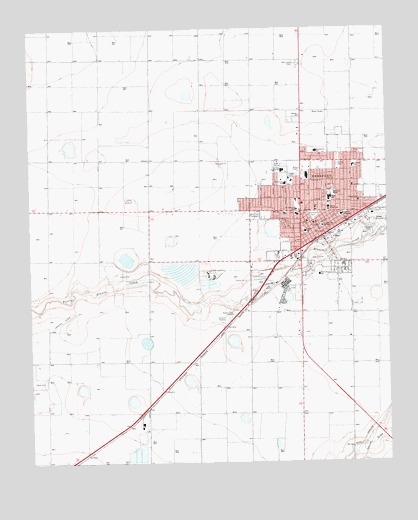
Hereford, TX USGS Topographic Map
Click on map above to begin viewing in our Map Viewer.

This topographic map contains these locations and features:
Feature Name Type Latitude Longitude GNIS ID View Map
Aikman Elementary SchoolSchoolN34.8353°W102.3873°1350912View Map
Aikman Elementary SchoolSchoolN34.8419°W102.3878°2004076View Map
Avenue Baptist ChurchChurchN34.8231°W102.4058°2018335View Map
Bible Baptist ChurchChurchN34.8295°W102.4180°2018336View Map
Bluebonnet Elementary SchoolSchoolN34.8394°W102.4004°1352501View Map
Bluebonnet Elementary SchoolSchoolN34.8390°W102.4038°2004022View Map
Calvary ChurchChurchN34.8498°W102.4052°1353585View Map
Central SchoolSchoolN34.8165°W102.4035°1354233View Map
Church of Christ CentralChurchN34.8240°W102.4080°2018340View Map
Church of GodChurchN34.8073°W102.3971°2018342View Map
City of HerefordCivilN34.8232°W102.4001°2410747View Map
Community ChurchChurchN34.8365°W102.3833°2018346View Map
Dameron ParkParkN34.8212°W102.4005°1355610View Map
Deaf Smith County CourthouseBuildingN34.8176°W102.3985°2030620View Map
Deaf Smith County Historical MuseumBuildingN34.8184°W102.3991°2014221View Map
Deaf Smith County JailBuildingN34.8182°W102.3982°2738806View Map
Deaf Smith County Sheriff's OfficeBuildingN34.8181°W102.3984°2750320View Map
E B Black HouseBuildingN34.8145°W102.4044°2031307View Map
Fellowship of Believers ChurchChurchN34.8276°W102.4233°2018347View Map
First Assembly of God ChurchChurchN34.8390°W102.4019°2018332View Map
First Temple Assembly of God ChurchChurchN34.8365°W102.3974°2018333View Map
HerefordPopulated PlaceN34.8151°W102.3977°1359066View Map
Hereford City HallBuildingN34.8156°W102.4011°2753708View Map
Hereford Emergency Medical ServiceBuildingN34.8388°W102.4139°2655887View Map
Hereford Fire DepartmentBuildingN34.8156°W102.4003°2551923View Map
Hereford High SchoolSchoolN34.8255°W102.3957°2004023View Map
Hereford Junior High SchoolSchoolN34.8340°W102.4122°2004024View Map
Hereford Police DepartmentBuildingN34.8154°W102.4010°2750449View Map
Hereford Post OfficePost OfficeN34.8180°W102.4000°2731402View Map
Hereford Regional Medical CenterHospitalN34.8395°W102.4139°2015583View Map
Jaycee ParkParkN34.8109°W102.3966°2029116View Map
KPAN-AM (Hereford)TowerN34.7995°W102.4283°1385582View Map
KPAN-FM (Hereford)TowerN34.7926°W102.4296°1385876View Map
La Plata Junior High SchoolSchoolN34.8345°W102.4113°1360809View Map
Mount Sinai Baptist ChurchChurchN34.8131°W102.4080°2018337View Map
North ParkParkN34.8356°W102.3921°1364105View Map
Northwest Elementary SchoolSchoolN34.8303°W102.4109°1364222View Map
Northwest Elementary SchoolSchoolN34.8295°W102.4099°2004026View Map
Parkside Chapel ChurchChurchN34.8195°W102.4013°2018348View Map
Rest Lawn CemeteryCemeteryN34.8647°W102.4062°1366370View Map
Saint Anthony Catholic SchoolSchoolN34.8226°W102.4061°1367135View Map
Saint Anthonys CemeteryCemeteryN34.8328°W102.4089°2773363View Map
Saint Thomas Episcopal ChurchChurchN34.8223°W102.4113°2018343View Map
Seventh Day Adventist ChurchChurchN34.8223°W102.4124°2018345View Map
Shirley Elementary SchoolSchoolN34.8284°W102.3935°2004027View Map
Shirley SchoolSchoolN34.8273°W102.3933°1368208View Map
Sonrise Baptist ChurchChurchN34.8253°W102.3833°2018338View Map
Spanish Church of ChristChurchN34.8301°W102.3980°2018341View Map
Stanton Junior High SchoolSchoolN34.8226°W102.3952°1369101View Map
Stanton Learning CenterSchoolN34.8226°W102.3960°2004025View Map
Temple Baptist ChurchChurchN34.8387°W102.3877°2018339View Map
Templo New Beginning Assembly of God ChurchChurchN34.8401°W102.3877°2018334View Map
The National Cowgirl Hall of Fame and Western Heritage CenterBuildingN34.8353°W102.4024°2014222View Map
Tierra Blanca Elementary SchoolSchoolN34.8039°W102.3995°1369927View Map
Tierra Blanca Elementary SchoolSchoolN34.8056°W102.3994°2004028View Map
Trinity Fellowship ChurchChurchN34.8309°W102.4155°2018349View Map
Veterans ParkParkN34.8167°W102.3813°1370629View Map
Wesley United Methodist ChurchChurchN34.8248°W102.3858°2018344View Map
West Central Elementary SchoolSchoolN34.8206°W102.4191°2004030View Map
West Park CemeteryCemeteryN34.8211°W102.4218°1371184View Map

Note: Coordinates in the location and feature list above are referenced to NAD83 datum.


Copyright (C) 2008-2025 Ryan Niemi / Sunset Dynamics ... All Rights Reserved