TopoQuest Logo
Do you find TopoQuest useful?
Help keep TopoQuest running and adding new maps/features by donating!
Bitcoin:  19c7KJd3qBynnjoSw5npx9KScwjBe4ifkT
Litecoin:  LXs6TkuXGGXo1vDsWCkWVdjQX94eUKd6ui
Home View Maps Find Maps Find Places Resources & Links


High Valley, Idaho Topographic Map

USGS Map Title: High Valley, ID
USGS Map MRC: 44116B2
DRG (GeoTIFF) Download: o44116b2.tif


Neighboring USGS Topographic Map Quads:


  Dodson Pass, ID  
44116C3
 

  Sage Hen Reservoir, ID  
44116C2
 

  Smiths Ferry, ID  
44116C1
 

  Ola, ID  
44116B3
 

  High Valley, ID  
44116B2
 

  Packer John Mountain, ID  
44116B1
 

  Webb Creek, ID  
44116A3
 

  Dry Buck Valley, ID  
44116A2
 

  Banks, ID  
44116A1


Map MRC Location:

N45°
W117°
N45°
W116°
H8 H7 H6 H5 H4 H3 H2 H1
G8 G7 G6 G5 G4 G3 G2 G1
F8 F7 F6 F5 F4 F3 F2 F1
E8 E7 E6 E5 E4 E3 E2 E1
D8 D7 D6 D5 D4 D3 D2 D1
C8 C7 C6 C5 C4 C3 C2 C1
B8 B7 B6 B5 B4 B3 B2 B1
A8 A7 A6 A5 A4 A3 A2 A1
N44°
W117°
N44°
W116°

High Valley, ID USGS 1:24K Topographic Map Preview:
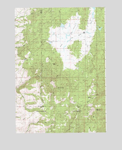
High Valley, ID USGS Topographic Map
Click on map above to begin viewing in our Map Viewer.

This topographic map contains these locations and features:
Feature Name Type Latitude Longitude GNIS ID View Map
Beal Number Three DamDamN44.2282°W116.1360°398808View Map
Big Eddy TrailTrailN44.1974°W116.1254°395100View Map
Cook KnobSummitN44.1466°W116.1482°399159View Map
Dry Buck MeadowFlatN44.1571°W116.1490°380776View Map
Dry Buck MountainSummitN44.1271°W116.1535°380777View Map
Dry Buck Mountain TrailTrailN44.1752°W116.1490°395317View Map
Dry Buck SummitGapN44.1518°W116.1679°396419View Map
Fletcher ButteSummitN44.1935°W116.1954°381859View Map
Hidden LakeReservoirN44.2466°W116.1926°398852View Map
Hidden Lake DamDamN44.2466°W116.1926°398851View Map
Hidden Lakes AirportAirportN44.2253°W116.1815°400776View Map
High ValleyValleyN44.1910°W116.1821°383178View Map
High ValleyPopulated PlaceN44.2241°W116.1549°395471View Map
High Valley Fire Protection AssociationBuildingN44.2426°W116.1459°2619187View Map
High Valley Ranger StationLocaleN44.2121°W116.1535°383179View Map
High Valley SchoolLocaleN44.2243°W116.1651°383180View Map
High Valley Swanson AirportAirportN44.2401°W116.1441°400780View Map
Holbrook DamDamN44.2449°W116.1376°398729View Map
Long Pine CreekStreamN44.1763°W116.2118°386076View Map
Mud LakeLakeN44.1406°W116.1412°387332View Map
North Fork Little Squaw CreekStreamN44.2063°W116.1835°387731View Map
Ola SummitSummitN44.1988°W116.2382°394866View Map
Padget CreekStreamN44.2221°W116.1804°388119View Map
Shirts CreekStreamN44.1804°W116.2162°400081View Map
Shirts Creek TrailTrailN44.1660°W116.2187°395939View Map
Timber GulchValleyN44.1696°W116.2493°392152View Map
Woodall DamDamN44.2132°W116.1543°398809View Map

Note: Coordinates in the location and feature list above are referenced to NAD83 datum.


Copyright (C) 2008-2025 Ryan Niemi / Sunset Dynamics ... All Rights Reserved