TopoQuest Logo
Do you find TopoQuest useful?
Help keep TopoQuest running and adding new maps/features by donating!
Bitcoin:  19c7KJd3qBynnjoSw5npx9KScwjBe4ifkT
Litecoin:  LXs6TkuXGGXo1vDsWCkWVdjQX94eUKd6ui
Home View Maps Find Maps Find Places Resources & Links


Hilham, Tennessee Topographic Map

USGS Map Title: Hilham, TN
USGS Map MRC: 36085D4
DRG (GeoTIFF) Download: o36085d4.tif


Neighboring USGS Topographic Map Quads:


  Celina, TN  
36085E5
 

  Dale Hollow Dam, TN  
36085E4
 

  Dale Hollow Reservoir SE, TN  
36085E3
 

  Burristown, TN  
36085D5
 

  Hilham, TN  
36085D4
 

  Livingston, TN  
36085D3
 

  Dodson Branch, TN  
36085C5
 

  Windle, TN  
36085C4
 

  Okalona, TN  
36085C3


Map MRC Location:

N37°
W86°
N37°
W85°
H8 H7 H6 H5 H4 H3 H2 H1
G8 G7 G6 G5 G4 G3 G2 G1
F8 F7 F6 F5 F4 F3 F2 F1
E8 E7 E6 E5 E4 E3 E2 E1
D8 D7 D6 D5 D4 D3 D2 D1
C8 C7 C6 C5 C4 C3 C2 C1
B8 B7 B6 B5 B4 B3 B2 B1
A8 A7 A6 A5 A4 A3 A2 A1
N36°
W86°
N36°
W85°

Hilham, TN USGS 1:24K Topographic Map Preview:
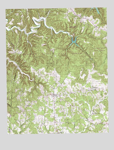
Hilham, TN USGS Topographic Map
Click on map above to begin viewing in our Map Viewer.

This topographic map contains these locations and features:
Feature Name Type Latitude Longitude GNIS ID View Map
Beech Springs School (historical)SchoolN36.4620°W85.4930°1645122View Map
Bethel CemeteryCemeteryN36.4806°W85.3897°1644893View Map
Bethel ChurchChurchN36.4803°W85.3894°1277135View Map
Bryans ForkStreamN36.4659°W85.4175°1278732View Map
Burchett CemeteryCemeteryN36.4926°W85.4041°1279024View Map
Burchett HollowValleyN36.4911°W85.4572°1279026View Map
Camp Ground CemeteryCemeteryN36.3751°W85.4339°1305626View Map
Camp Ground ChurchChurchN36.3753°W85.4352°1279390View Map
Concord CemeteryCemeteryN36.4553°W85.4408°1281062View Map
Cooper MountainSummitN36.4615°W85.3925°1281216View Map
Dry CreekStreamN36.4484°W85.4964°1282924View Map
Fairview SchoolSchoolN36.4923°W85.4125°1284042View Map
Fish AcademySchoolN36.4134°W85.4405°1284302View Map
Fisk CemeteryCemeteryN36.4069°W85.4369°2426910View Map
Flat CreekPopulated PlaceN36.3851°W85.3822°1647292View Map
Flat Creek CemeteryCemeteryN36.3945°W85.3886°1284385View Map
Flat Creek ChurchChurchN36.3845°W85.3816°1284386View Map
Goodpasture MountainSummitN36.4451°W85.4461°1285651View Map
Gore-Poston Family CemeteryCemeteryN36.3989°W85.4922°2426909View Map
Grey (historical)Populated PlaceN36.4687°W85.3864°1310294View Map
Hawkins Family CemeteryCemeteryN36.4337°W85.4814°2044256View Map
HilhamPopulated PlaceN36.4142°W85.4416°1287776View Map
Hilham CemeteryCemeteryN36.4131°W85.4350°1644905View Map
Hilham Church of ChristChurchN36.4131°W85.4344°1644906View Map
Hilham Division (historical)CensusN36.3906°W85.4369°1648904View Map
Hilham Elementary SchoolSchoolN36.4123°W85.4414°1315925View Map
Hilham Post OfficePost OfficeN36.4138°W85.4407°1650258View Map
Hilham United Methodist ChurchChurchN36.4137°W85.4402°1644907View Map
Hilham Volunteer Fire DepartmentBuildingN36.4071°W85.4337°2654470View Map
Hix (historical)Populated PlaceN36.4542°W85.4822°1310296View Map
Holly SpringsPopulated PlaceN36.4190°W85.3997°1288112View Map
Holly Springs CemeteryCemeteryN36.4189°W85.3952°1644908View Map
Holly Springs School (historical)SchoolN36.4181°W85.3944°1317268View Map
Jackson BranchStreamN36.3751°W85.4152°1289186View Map
Johnie Humpy Brown CemeteryCemeteryN36.4306°W85.4625°2414812View Map
Johnson CoveValleyN36.4504°W85.3759°1289593View Map
Mawell ChapelChurchN36.4031°W85.4725°1292968View Map
Maxwell Chapel CemeteryCemeteryN36.4076°W85.4755°1292984View Map
McFerrin CemeteryCemeteryN36.4903°W85.4075°1644911View Map
McFerrin ChurchChurchN36.4906°W85.4077°1293294View Map
Mill Creek Chapel (historical)ChurchN36.4803°W85.4969°1645128View Map
Mill Creek School (historical)SchoolN36.4806°W85.4972°1645129View Map
Morgan CreekStreamN36.4656°W85.4147°1294366View Map
Nalier BranchStreamN36.4062°W85.3847°1295207View Map
Nalier SpringSpringN36.4203°W85.3933°1295208View Map
New Liberty SchoolSchoolN36.4178°W85.4794°1295592View Map
Oak Grove SchoolSchoolN36.3767°W85.4564°1296131View Map
Old Flat Creek ChurchChurchN36.3945°W85.3897°1296307View Map
Old Union CemeteryCemeteryN36.3864°W85.4264°1644919View Map
Old Union ChurchChurchN36.3853°W85.4255°1296389View Map
Rich BranchStreamN36.4737°W85.4733°1299306View Map
Standing Stone Rustic Park Historic DistrictParkN36.4703°W85.4161°1326730View Map
Standing Stone State ForestParkN36.4567°W85.4219°1303792View Map
Standing Stone State Rustic ParkParkN36.4792°W85.4152°1271228View Map
Standingstone LakeReservoirN36.4666°W85.4158°1303793View Map
Tennessee Department of Agriculture Division of Forestry Standing StoneBuildingN36.4447°W85.4451°2654775View Map
TimothyPopulated PlaceN36.4892°W85.4069°1272657View Map
Timothy Volunteer Fire DepartmentBuildingN36.4908°W85.4067°2654572View Map
Wilson MountainSummitN36.4342°W85.4094°1274839View Map

Note: Coordinates in the location and feature list above are referenced to NAD83 datum.


Copyright (C) 2008-2024 Ryan Niemi / Sunset Dynamics ... All Rights Reserved