TopoQuest Logo
Do you find TopoQuest useful?
Help keep TopoQuest running and adding new maps/features by donating!
Bitcoin:  19c7KJd3qBynnjoSw5npx9KScwjBe4ifkT
Litecoin:  LXs6TkuXGGXo1vDsWCkWVdjQX94eUKd6ui
Home View Maps Find Maps Find Places Resources & Links


Hiltons, Virginia Topographic Map

USGS Map Title: Hiltons, VA
USGS Map MRC: 36082F4
DRG (GeoTIFF) Download: o36082f4.tif


Neighboring USGS Topographic Map Quads:


  Fort Blackmore, VA  
36082G5
 

  Dungannon, VA  
36082G4
 

  Moll Creek, VA  
36082G3
 

  Gate City, VA  
36082F5
 

  Hiltons, VA  
36082F4
 

  Mendota, VA  
36082F3
 

  Kingsport, TN  
36082E5
 

  Indian Springs, TN  
36082E4
 

  Blountville, TN  
36082E3


Map MRC Location:

N37°
W83°
N37°
W82°
H8 H7 H6 H5 H4 H3 H2 H1
G8 G7 G6 G5 G4 G3 G2 G1
F8 F7 F6 F5 F4 F3 F2 F1
E8 E7 E6 E5 E4 E3 E2 E1
D8 D7 D6 D5 D4 D3 D2 D1
C8 C7 C6 C5 C4 C3 C2 C1
B8 B7 B6 B5 B4 B3 B2 B1
A8 A7 A6 A5 A4 A3 A2 A1
N36°
W83°
N36°
W82°

Hiltons, VA USGS 1:24K Topographic Map Preview:
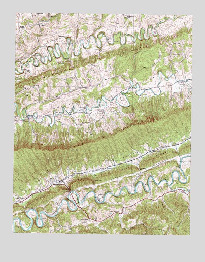
Hiltons, VA USGS Topographic Map
Click on map above to begin viewing in our Map Viewer.

This topographic map contains these locations and features:
Feature Name Type Latitude Longitude GNIS ID View Map
Addington CemeteryCemeteryN36.7362°W82.4651°1498023View Map
Addington CemeteryCemeteryN36.7377°W82.4634°2766698View Map
Addington ChurchChurchN36.7365°W82.4638°1462367View Map
Amos BranchStreamN36.7373°W82.4452°1481304View Map
Bald Alley BluffCliffN36.6437°W82.4596°1462710View Map
Beech Grove SchoolSchoolN36.6493°W82.3751°1463004View Map
Big BranchStreamN36.6948°W82.4921°1463308View Map
Blankenbeckler CemeteryCemeteryN36.7490°W82.4721°1498034View Map
Blue Springs BranchStreamN36.6490°W82.4135°1463596View Map
Brickyard GapGapN36.6390°W82.4910°1463806View Map
Bright HollowValleyN36.6309°W82.4406°1463826View Map
BrunoPopulated PlaceN36.6376°W82.4221°1495315View Map
Callahan SpurRidgeN36.6412°W82.3951°1464256View Map
Castle CemeteryCemeteryN36.7454°W82.3779°1498051View Map
Cave Spring HollowValleyN36.7173°W82.4153°1464576View Map
Cedar Point SchoolSchoolN36.6957°W82.4404°1464645View Map
Champ BranchStreamN36.7115°W82.4182°1464721View Map
Cove CreekStreamN36.6529°W82.3896°1462302View Map
Culbertson CreekStreamN36.7473°W82.4754°1482877View Map
Darthula Baptist Church CemeteryCemeteryN36.6463°W82.4394°2766657View Map
Darthula ChurchChurchN36.6465°W82.4399°1465619View Map
Davis CemeteryCemeteryN36.7071°W82.4911°2766658View Map
Dean BranchStreamN36.7162°W82.3888°1465681View Map
Dean ChapelChurchN36.7340°W82.3885°1465684View Map
Dean Family CemeteryCemeteryN36.7339°W82.3886°2766660View Map
District 2CivilN36.6417°W82.4303°1927212View Map
District 3CivilN36.7444°W82.4531°1927363View Map
Dorton FortPopulated PlaceN36.7351°W82.4349°1477271View Map
Dowell BranchStreamN36.6493°W82.4435°1465922View Map
Dowell GapGapN36.6554°W82.4426°1465923View Map
Dry BranchStreamN36.6504°W82.3882°1465965View Map
East Fork Roberts CreekStreamN36.6293°W82.4232°1466105View Map
Eddington GapGapN36.6623°W82.4113°1466169View Map
Ewing ChapelChurchN36.6898°W82.4849°1466375View Map
Farmers Exchange Mill (historical)LocaleN36.7451°W82.4782°1498066View Map
Foust FordCrossingN36.6362°W82.4896°1495563View Map
Fowlers BranchStreamN36.6273°W82.4874°1466814View Map
Fraley CemeteryCemeteryN36.7498°W82.4715°2766690View Map
Francisco CemeteryCemeteryN36.6878°W82.4519°1466845View Map
FulkersonPopulated PlaceN36.6626°W82.4346°1495572View Map
Gaines ChapelChurchN36.6332°W82.4465°1466940View Map
Gardner CemeteryCemeteryN36.6395°W82.4210°1466985View Map
Gouldman BranchStreamN36.6493°W82.3785°1467294View Map
Greenwood SchoolSchoolN36.6904°W82.4860°1467528View Map
Hamilton GapGapN36.6726°W82.4610°1467681View Map
Hart FordCrossingN36.6326°W82.4796°1495660View Map
Harts Hill Church (historical)ChurchN36.6295°W82.4588°1498094View Map
Hickam CemeteryCemeteryN36.6499°W82.3776°1467971View Map
Hilton Elementary SchoolSchoolN36.6548°W82.4637°1498096View Map
HiltonsPopulated PlaceN36.6545°W82.4671°1468068View Map
Hiltons CreekStreamN36.6487°W82.4593°1468069View Map
Hiltons GapGapN36.6498°W82.4604°1468070View Map
Hiltons Post OfficePost OfficeN36.6534°W82.4665°2766461View Map
Hiltons Volunteer Fire DepartmentBuildingN36.6521°W82.4752°2085971View Map
Holston River MillLocaleN36.6459°W82.4410°1468174View Map
Jett GapGapN36.6720°W82.3838°1468735View Map
Lark BranchStreamN36.7123°W82.4176°1469137View Map
Lawson CemeteryCemeteryN36.6873°W82.4988°1469211View Map
Little ValleyValleyN36.6491°W82.4567°1469681View Map
Maces SpringPopulated PlaceN36.6723°W82.4026°1477040View Map
Maces Spring School (historical)SchoolN36.6662°W82.4132°1498110View Map
McConnellPopulated PlaceN36.7312°W82.4802°1495914View Map
McConnell MillPopulated PlaceN36.6965°W82.4493°1495915View Map
McCorklePopulated PlaceN36.6762°W82.3860°1498113View Map
McMurray CemeteryCemeteryN36.6287°W82.3913°1470281View Map
Miller KnobSummitN36.6415°W82.3818°1495949View Map
Moccasin RidgeRidgeN36.7318°W82.4132°1485507View Map
Morgan ChapelChurchN36.7409°W82.4968°1470734View Map
Mount Vernon ChurchChurchN36.6765°W82.3874°1471086View Map
New Bethel ChurchChurchN36.6926°W82.4652°1471389View Map
New Hope ChurchChurchN36.7054°W82.4249°1471431View Map
Otter House BluffCliffN36.6443°W82.4538°1471965View Map
Owen CornerPopulated PlaceN36.6426°W82.4943°1477600View Map
Pine RidgeRidgeN36.6562°W82.4479°1474266View Map
Roberts CreekStreamN36.6443°W82.4354°1473317View Map
Saint Joseph Church (historical)ChurchN36.7082°W82.3776°1498169View Map
Saratoga School (historical)SchoolN36.7268°W82.4596°1498171View Map
Sayler ChapelChurchN36.7284°W82.3876°1474086View Map
Sled CreekStreamN36.6345°W82.4707°1474684View Map
SnowflakePopulated PlaceN36.6898°W82.4899°1477766View Map
Spuryer CemeteryCemeteryN36.6559°W82.4024°1475037View Map
Stony Point ChurchChurchN36.6370°W82.4260°1475216View Map
Sugar Tree ChurchChurchN36.7262°W82.4885°1475291View Map
Valley Creek ChapelChurchN36.7429°W82.4832°1476135View Map

Note: Coordinates in the location and feature list above are referenced to NAD83 datum.


Copyright (C) 2008-2024 Ryan Niemi / Sunset Dynamics ... All Rights Reserved