TopoQuest Logo
Do you find TopoQuest useful?
Help keep TopoQuest running and adding new maps/features by donating!
Bitcoin:  19c7KJd3qBynnjoSw5npx9KScwjBe4ifkT
Litecoin:  LXs6TkuXGGXo1vDsWCkWVdjQX94eUKd6ui
Home View Maps Find Maps Find Places Resources & Links


Homestead, Montana Topographic Map

USGS Map Title: Homestead, MT
USGS Map MRC: 48104D5
DRG (GeoTIFF) Download: o48104d5.tif


Neighboring USGS Topographic Map Quads:


  Flagstaff Hill, MT  
48104E6
 

  Alkali Coulee, MT  
48104E5
 

  Reserve, MT  
48104E4
 

  Homestead NW, MT  
48104D6
 

  Homestead, MT  
48104D5
 

  Medicine Lake, MT  
48104D4
 

  Rocky Point, MT  
48104C6
 

  Johnson Lake, MT  
48104C5
 

  Froid, MT  
48104C4


Map MRC Location:

N49°
W105°
N49°
W104°
H8 H7 H6 H5 H4 H3 H2 H1
G8 G7 G6 G5 G4 G3 G2 G1
F8 F7 F6 F5 F4 F3 F2 F1
E8 E7 E6 E5 E4 E3 E2 E1
D8 D7 D6 D5 D4 D3 D2 D1
C8 C7 C6 C5 C4 C3 C2 C1
B8 B7 B6 B5 B4 B3 B2 B1
A8 A7 A6 A5 A4 A3 A2 A1
N48°
W105°
N48°
W104°

Homestead, MT USGS 1:24K Topographic Map Preview:
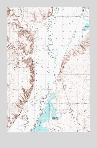
Homestead, MT USGS Topographic Map
Click on map above to begin viewing in our Map Viewer.

This topographic map contains these locations and features:
Feature Name Type Latitude Longitude GNIS ID View Map
29N56E04CDB_01 WellWellN48.3784°W104.5141°1635204View Map
30N55E01BAB_01 WellWellN48.3881°W104.5202°1635260View Map
30N55E03AAAA01 WellWellN48.3889°W104.5422°1635262View Map
31N55E18DBAB01 WellWellN48.4389°W104.6130°1635545View Map
31N55E23DCCD01 WellWellN48.4189°W104.5283°1635444View Map
31N55E29AABD01 WellWellN48.4167°W104.5877°1635423View Map
31N55E35CBDB01 WellWellN48.3939°W104.5377°1635286View Map
Dam Number 4DamN48.4770°W104.5094°770440View Map
Dam Number 6DamN48.4089°W104.5705°770441View Map
Farmers Elevator Company of FroidLocaleN48.4211°W104.5388°1677579View Map
First Lutheran ChurchChurchN48.4222°W104.5369°1677457View Map
HomesteadLocaleN48.4211°W104.5388°1677563View Map
HomesteadPopulated PlaceN48.4211°W104.5388°772498View Map
Homestead ElevatorLocaleN48.4200°W104.5405°1677578View Map
Homestead High School (historical)SchoolN48.4231°W104.5375°1677458View Map
Homestead LakeReservoirN48.3876°W104.5680°772502View Map
Homestead Post Office (historical)Post OfficeN48.3872°W104.5019°1677564View Map
Homestead Post Office (historical)Post OfficeN48.4211°W104.5388°1677568View Map
Lake CreekStreamN48.4486°W104.5519°773179View Map
Lost CreekStreamN48.3886°W104.5538°773692View Map
McCabe CreekStreamN48.3922°W104.5266°773962View Map
Medicine Lake Refuge Number 4 DamDamN48.4767°W104.5088°795716View Map
Medicine Structure DamDamN48.3850°W104.5788°798533View Map
Miller School (historical)SchoolN48.3811°W104.5072°1669298View Map
Nazarene Church (historical)ChurchN48.4209°W104.5386°1677456View Map
Sauerkraut CouleeValleyN48.4495°W104.5836°776232View Map
Wolf CreekStreamN48.4581°W104.5630°778640View Map

Note: Coordinates in the location and feature list above are referenced to NAD83 datum.


Copyright (C) 2008-2024 Ryan Niemi / Sunset Dynamics ... All Rights Reserved