TopoQuest Logo
Do you find TopoQuest useful?
Help keep TopoQuest running and adding new maps/features by donating!
Bitcoin:  19c7KJd3qBynnjoSw5npx9KScwjBe4ifkT
Litecoin:  LXs6TkuXGGXo1vDsWCkWVdjQX94eUKd6ui
Home View Maps Find Maps Find Places Resources & Links


Hope, Idaho Topographic Map

USGS Map Title: Hope, ID
USGS Map MRC: 48116B3
DRG (GeoTIFF) Download: o48116b3.tif


Neighboring USGS Topographic Map Quads:


  Oden Bay, ID  
48116C4
 

  Trout Peak, ID  
48116C3
 

  Trestle Peak, ID  
48116C2
 

  Talache, ID  
48116B4
 

  Hope, ID  
48116B3
 

  Clark Fork, ID  
48116B2
 

  Minerva Peak, ID  
48116A4
 

  Packsaddle Mountain, ID  
48116A3
 

  Derr Point, ID  
48116A2


Map MRC Location:

N49°
W117°
N49°
W116°
H8 H7 H6 H5 H4 H3 H2 H1
G8 G7 G6 G5 G4 G3 G2 G1
F8 F7 F6 F5 F4 F3 F2 F1
E8 E7 E6 E5 E4 E3 E2 E1
D8 D7 D6 D5 D4 D3 D2 D1
C8 C7 C6 C5 C4 C3 C2 C1
B8 B7 B6 B5 B4 B3 B2 B1
A8 A7 A6 A5 A4 A3 A2 A1
N48°
W117°
N48°
W116°

Hope, ID USGS 1:24K Topographic Map Preview:
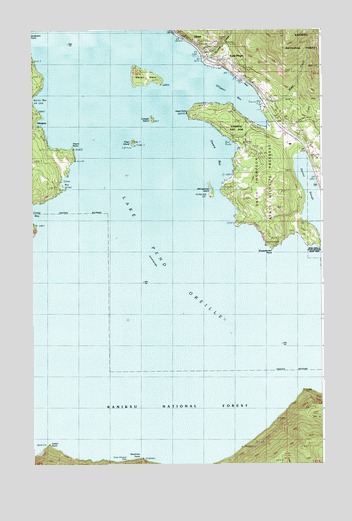
Hope, ID USGS Topographic Map
Click on map above to begin viewing in our Map Viewer.

This topographic map contains these locations and features:
Feature Name Type Latitude Longitude GNIS ID View Map
Camp BayBayN48.1983°W116.3744°378752View Map
Carter CreekStreamN48.2244°W116.2580°400371View Map
City of East HopeCivilN48.2414°W116.2913°2410387View Map
City of HopeCivilN48.2493°W116.3043°2410791View Map
Clark ForkStreamN48.1833°W116.2691°798973View Map
Cottage IslandIslandN48.2244°W116.3232°379813View Map
David Thompson Historical MonumentLocaleN48.2438°W116.3027°394181View Map
David Thompson State Wildlife PreserveParkN48.2038°W116.2721°396375View Map
Deadman PointCapeN48.1269°W116.3280°380337View Map
Denton SloughGutN48.2019°W116.2557°380516View Map
East HopePopulated PlaceN48.2419°W116.2955°396435View Map
Elliot BayBayN48.2063°W116.3605°381424View Map
Ellisport BayBayN48.2338°W116.2918°381434View Map
GlengaryPopulated PlaceN48.2219°W116.3746°396557View Map
HopePopulated PlaceN48.2477°W116.3071°396664View Map
Hope - East Hope Volunteer Fire DepartmentBuildingN48.2427°W116.2985°2619004View Map
Hope CemeteryCemeteryN48.2456°W116.2981°394182View Map
Hope Elementary SchoolSchoolN48.2430°W116.2996°401379View Map
Hope PointCapeN48.2258°W116.3074°383323View Map
Hope Post OfficePost OfficeN48.2434°W116.3004°2781733View Map
Indian PointCapeN48.1302°W116.3685°383703View Map
Jakes MountainSummitN48.1294°W116.2593°400960View Map
Lake Pend Oreille Seaplane BaseAirportN48.2166°W116.3607°400821View Map
Martin BayBayN48.2283°W116.3705°386507View Map
Memaloose IslandIslandN48.2035°W116.2971°399007View Map
North Fork Clark ForkStreamN48.1849°W116.2693°387673View Map
Owens BayBayN48.2160°W116.2971°388045View Map
Pearl IslandIslandN48.2177°W116.3310°388307View Map
Picard PointCapeN48.2163°W116.3577°388414View Map
Riser CreekStreamN48.2297°W116.2766°389399View Map
Sam Owen Fire DistrictBuildingN48.2207°W116.2653°2619331View Map
Samowen CampgroundLocaleN48.2188°W116.2888°400391View Map
Samowen ParkParkN48.2199°W116.2913°399221View Map
Sheepherder PointCapeN48.1944°W116.2877°390271View Map
Strong CreekStreamN48.2430°W116.2982°391544View Map
Sulphide MineMineN48.1927°W116.3738°391598View Map
Sunrise BayBayN48.2441°W116.3730°391664View Map
Warren IslandIslandN48.2366°W116.3268°399013View Map

Note: Coordinates in the location and feature list above are referenced to NAD83 datum.


Copyright (C) 2008-2024 Ryan Niemi / Sunset Dynamics ... All Rights Reserved