TopoQuest Logo
Do you find TopoQuest useful?
Help keep TopoQuest running and adding new maps/features by donating!
Bitcoin:  19c7KJd3qBynnjoSw5npx9KScwjBe4ifkT
Litecoin:  LXs6TkuXGGXo1vDsWCkWVdjQX94eUKd6ui
Home View Maps Find Maps Find Places Resources & Links


Horse Mountain, Texas Topographic Map

USGS Map Title: Horse Mountain, TX
USGS Map MRC: 30103A1
DRG (GeoTIFF) Download: o30103a1.tif


Neighboring USGS Topographic Map Quads:


  Marathon, TX  
30103B2
 

  Lightning Hills, TX  
30103B1
 

  Housetop Mountains, TX  
30102B8
 

  Pena Blanca Mountains, TX  
30103A2
 

  Horse Mountain, TX  
30103A1
 

  Tesnus, TX  
30102A8
 

  Heart Mountain, TX  
29103H2
 

  Hood Spring, TX  
29103H1
 

  Pine Mountain West, TX  
29102H8


Map MRC Location:

N31°
W104°
N31°
W103°
H8 H7 H6 H5 H4 H3 H2 H1
G8 G7 G6 G5 G4 G3 G2 G1
F8 F7 F6 F5 F4 F3 F2 F1
E8 E7 E6 E5 E4 E3 E2 E1
D8 D7 D6 D5 D4 D3 D2 D1
C8 C7 C6 C5 C4 C3 C2 C1
B8 B7 B6 B5 B4 B3 B2 B1
A8 A7 A6 A5 A4 A3 A2 A1
N30°
W104°
N30°
W103°

Horse Mountain, TX USGS 1:24K Topographic Map Preview:
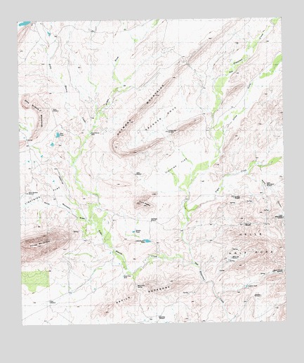
Horse Mountain, TX USGS Topographic Map
Click on map above to begin viewing in our Map Viewer.

This topographic map contains these locations and features:
Feature Name Type Latitude Longitude GNIS ID View Map
Arden DrawValleyN30.0786°W103.0918°2088826View Map
Bee Cave WindmillLocaleN30.0406°W103.0194°2088910View Map
Bennett Place (historical)Populated PlaceN30.0752°W103.0343°1377990View Map
Bennett Place (historical)Populated PlaceN30.1213°W103.0091°1377991View Map
Bois d'Arc SpringLocaleN30.0157°W103.0709°2088900View Map
Boots WindmillLocaleN30.0882°W103.1095°2088828View Map
Catfish TankReservoirN30.0150°W103.0191°2088907View Map
Cedar WindmillLocaleN30.0619°W103.0706°2088830View Map
China DrawValleyN30.0706°W103.0307°1332766View Map
Cry Baby WindmillLocaleN30.0521°W103.0243°2088912View Map
Dead Cow HoleReservoirN30.0199°W103.0772°2088901View Map
Dead Horse HoleLakeN30.0786°W103.0917°2088827View Map
Devils BackboneRidgeN30.0119°W103.0674°1334289View Map
East Nine WindmillLocaleN30.0110°W103.0155°2088906View Map
Fighting FlatFlatN30.0618°W103.0477°1335784View Map
Granger CoveBasinN30.0848°W103.0574°2088914View Map
Granger Cove WindmillLocaleN30.0790°W103.0550°2088832View Map
Haymond MountainsSummitN30.0918°W103.0621°1337499View Map
Hells Half AcreSummitN30.0366°W103.0068°1337578View Map
Horse MountainSummitN30.0327°W103.1174°1377900View Map
Horse Mountain DrawValleyN30.0415°W103.0908°2088915View Map
Horse Mountain WindmillLocaleN30.0545°W103.1216°2088898View Map
Lightning FlatFlatN30.0527°W103.1168°1339918View Map
Little Boulder TankLocaleN30.0342°W103.0644°2088902View Map
Lower Water Canyon WindmillLocaleN30.0559°W103.0094°2088913View Map
Marathon DivisionCivilN30.0218°W103.0172°1938959View Map
Middle TankReservoirN30.0382°W103.0721°2088903View Map
Negro CreekStreamN30.0418°W103.0471°1342406View Map
Old Corbett PlacePopulated PlaceN30.0252°W103.0441°1378793View Map
Old Edith Lochausen PlacePopulated PlaceN30.1152°W103.0893°1378795View Map
Peņa Blanca CreekStreamN30.0246°W103.0452°1377806View Map
Rice WindmillLocaleN30.0101°W103.1123°2088899View Map
Steel TankReservoirN30.0778°W103.1068°2088829View Map
Twin PeaksSummitN30.0496°W103.0696°1348967View Map
Twin Peaks WindmillLocaleN30.0421°W103.0638°2088904View Map
Upper Water Canyon WindmillLocaleN30.0431°W103.0013°2088911View Map
Wagner Wildcat WindmillLocaleN30.0205°W103.0021°2088908View Map
Water CanyonValleyN30.0614°W103.0175°2088922View Map
West Nine WindmillLocaleN30.0030°W103.0607°2088905View Map
White Hog WindmillLocaleN30.0268°W103.0258°2088909View Map

Note: Coordinates in the location and feature list above are referenced to NAD83 datum.


Copyright (C) 2008-2025 Ryan Niemi / Sunset Dynamics ... All Rights Reserved