TopoQuest Logo
Do you find TopoQuest useful?
Help keep TopoQuest running and adding new maps/features by donating!
Bitcoin:  19c7KJd3qBynnjoSw5npx9KScwjBe4ifkT
Litecoin:  LXs6TkuXGGXo1vDsWCkWVdjQX94eUKd6ui
Home View Maps Find Maps Find Places Resources & Links


Horseshoe Bend, New Mexico Topographic Map

USGS Map Title: Horseshoe Bend, NM
USGS Map MRC: 33104C8
DRG (GeoTIFF) Download: o33104c8.tif


Neighboring USGS Topographic Map Quads:


  Nelson Canyon East, NM  
33105D1
 

  Horseshoe Bend NW, NM  
33104D8
 

  Blackwater Hill, NM  
33104D7
 

  Sunset, NM  
33105C1
 

  Horseshoe Bend, NM  
33104C8
 

  Diamond A Ranch, NM  
33104C7
 

  Flying H NE, NM  
33105B1
 

  Skunk Canyon, NM  
33104B8
 

  Lucky Lake, NM  
33104B7


Map MRC Location:

N34°
W105°
N34°
W104°
H8 H7 H6 H5 H4 H3 H2 H1
G8 G7 G6 G5 G4 G3 G2 G1
F8 F7 F6 F5 F4 F3 F2 F1
E8 E7 E6 E5 E4 E3 E2 E1
D8 D7 D6 D5 D4 D3 D2 D1
C8 C7 C6 C5 C4 C3 C2 C1
B8 B7 B6 B5 B4 B3 B2 B1
A8 A7 A6 A5 A4 A3 A2 A1
N33°
W105°
N33°
W104°

Horseshoe Bend, NM USGS 1:24K Topographic Map Preview:
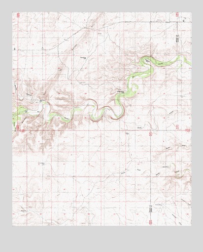
Horseshoe Bend, NM USGS Topographic Map
Click on map above to begin viewing in our Map Viewer.

This topographic map contains these locations and features:
Feature Name Type Latitude Longitude GNIS ID View Map
12586 Water WellWellN33.3526°W104.8766°928460View Map
Bar H FarmLocaleN33.3209°W104.9458°886048View Map
Bonney CanyonValleyN33.3157°W104.9986°886597View Map
Border CanyonValleyN33.3126°W104.9741°886628View Map
Border FarmLocaleN33.3190°W104.9791°886630View Map
Border Farm WellWellN33.3234°W104.9825°886631View Map
Border WellWellN33.2584°W104.9897°886634View Map
Clarence WellWellN33.2843°W104.8911°887636View Map
Divide CampLocaleN33.2623°W104.8966°888407View Map
Francisco Cordova Homestead (historical)LocaleN33.3340°W104.9525°898314View Map
High Lonesome WellWellN33.2859°W104.9772°889960View Map
Horseshoe BendBendN33.3462°W104.9064°890186View Map
Maney WellWellN33.3034°W104.9186°891571View Map
North WindmillLocaleN33.2798°W104.9311°909208View Map
Nuņez RanchLocaleN33.3357°W104.9608°892766View Map
Ridgill WellWellN33.3170°W104.9916°900583View Map
Rock House TankReservoirN33.3481°W104.9485°894053View Map
Serapio Nuņez TankReservoirN33.3279°W104.9221°894725View Map
Sevenhundred and Seventyseven WellWellN33.3618°W104.9408°894731View Map
SpringLocaleN33.3148°W104.9261°895242View Map

Note: Coordinates in the location and feature list above are referenced to NAD83 datum.


Copyright (C) 2008-2025 Ryan Niemi / Sunset Dynamics ... All Rights Reserved