TopoQuest Logo
Do you find TopoQuest useful?
Help keep TopoQuest running and adding new maps/features by donating!
Bitcoin:  19c7KJd3qBynnjoSw5npx9KScwjBe4ifkT
Litecoin:  LXs6TkuXGGXo1vDsWCkWVdjQX94eUKd6ui
Home View Maps Find Maps Find Places Resources & Links


Howard City, Michigan Topographic Map

USGS Map Title: Howard City, MI
USGS Map MRC: 43085D4
DRG (GeoTIFF) Download: o43085d4.tif


Neighboring USGS Topographic Map Quads:


  Big Bend, MI  
43085E5
 

  Stanwood, MI  
43085E4
 

  Altona, MI  
43085E3
 

  Tift Corner, MI  
43085D5
 

  Howard City, MI  
43085D4
 

  Lakeview, MI  
43085D3
 

  Sand Lake, MI  
43085C5
 

  Coral, MI  
43085C4
 

  Trufant, MI  
43085C3


Map MRC Location:

N44°
W86°
N44°
W85°
H8 H7 H6 H5 H4 H3 H2 H1
G8 G7 G6 G5 G4 G3 G2 G1
F8 F7 F6 F5 F4 F3 F2 F1
E8 E7 E6 E5 E4 E3 E2 E1
D8 D7 D6 D5 D4 D3 D2 D1
C8 C7 C6 C5 C4 C3 C2 C1
B8 B7 B6 B5 B4 B3 B2 B1
A8 A7 A6 A5 A4 A3 A2 A1
N43°
W86°
N43°
W85°

Howard City, MI USGS 1:24K Topographic Map Preview:
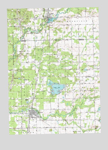
Howard City, MI USGS Topographic Map
Click on map above to begin viewing in our Map Viewer.

This topographic map contains these locations and features:
Feature Name Type Latitude Longitude GNIS ID View Map
Aetna CemeteryCemeteryN43.4906°W85.4598°1618994View Map
AmblePopulated PlaceN43.4314°W85.3886°1619021View Map
Amble CemeteryCemeteryN43.4353°W85.4025°1619022View Map
Amble Post Office (historical)Post OfficeN43.4314°W85.3886°2560222View Map
Amble Station (historical)LocaleN43.4306°W85.3903°2560002View Map
Amble Volunteer Fire DepartmentBuildingN43.4311°W85.3898°2636146View Map
Anderson Airport (historical)AirportN43.4284°W85.4548°1623967View Map
Bethel Lutheran ChurchChurchN43.4319°W85.4389°2561635View Map
Big CreekStreamN43.4859°W85.4456°1619190View Map
Body of Christ Family ChurchChurchN43.4444°W85.4569°2561640View Map
Boyd CemeteryCemeteryN43.4797°W85.3820°1619299View Map
Burley LakeLakeN43.4295°W85.4773°1619371View Map
Christ the King ChurchChurchN43.4333°W85.4614°2561638View Map
Conger Post Office (historical)Post OfficeN43.4467°W85.4567°2560182View Map
Conger Station (historical)LocaleN43.4467°W85.4567°2559944View Map
Crane LakeLakeN43.4380°W85.3945°1619611View Map
Deerfield ChurchChurchN43.4784°W85.3850°1619697View Map
Edgerton Upper Elementary SchoolSchoolN43.3969°W85.4644°2561630View Map
Ensley ParkParkN43.3950°W85.4633°2561625View Map
First Baptist ChurchChurchN43.3928°W85.4664°2561633View Map
First Baptist ChurchChurchN43.4931°W85.4444°2519011View Map
Gaffield SchoolSchoolN43.4084°W85.3814°1619984View Map
Grace Community ChurchChurchN43.4425°W85.4622°2561639View Map
Henkel LakeLakeN43.4306°W85.4852°1620173View Map
Herbert J Peck ParkParkN43.3931°W85.4692°2561623View Map
Howard CityPopulated PlaceN43.3956°W85.4678°1620259View Map
Howard City Fire DepartmentBuildingN43.3960°W85.4688°2561636View Map
Howard City Police DepartmentBuildingN43.3960°W85.4687°2561629View Map
Howard City Post OfficePost OfficeN43.3958°W85.4697°2561627View Map
Howard City Station (historical)LocaleN43.3978°W85.4697°2561626View Map
Indian Creek DrainCanalN43.4170°W85.4581°1622466View Map
Indian LakeLakeN43.4200°W85.4334°1622467View Map
Interchange 120CrossingN43.4250°W85.4947°2561850View Map
Interchange 125CrossingN43.4900°W85.4847°2541747View Map
Krampe LakeLakeN43.3869°W85.3753°1620457View Map
MacNaughton Elementary SchoolSchoolN43.3919°W85.4672°2561632View Map
Marne United Methodist ChurchChurchN43.4758°W85.3875°2519010View Map
Mecosta Pines RV ParkLocaleN43.4847°W85.4514°2518829View Map
Minnie Farmer ParkParkN43.3983°W85.4619°2561624View Map
MorleyPopulated PlaceN43.4909°W85.4439°1620897View Map
Morley Area Fire DepartmentBuildingN43.4901°W85.4526°2519012View Map
Morley Elementary SchoolSchoolN43.4953°W85.4439°2519013View Map
Morley Police DepartmentBuildingN43.4898°W85.4446°2737618View Map
Morley PondLakeN43.4882°W85.4396°1620899View Map
Morley Post OfficePost OfficeN43.4903°W85.4447°2519009View Map
Morley Rest AreaLocaleN43.4600°W85.4758°2561845View Map
Morley Station (historical)LocaleN43.4883°W85.4450°2519008View Map
North Greenville Station (historical)LocaleN43.4103°W85.4656°2559948View Map
Reynold Post Office (historical)Post OfficeN43.4103°W85.4656°2560065View Map
Reynolds CemeteryCemeteryN43.4109°W85.4764°1621376View Map
Reynolds Township LibraryBuildingN43.3986°W85.4689°2561628View Map
Saint Apollonia CemeteryCemeteryN43.4909°W85.4278°636551View Map
Tamarack Estates Mobile Home ParkPopulated PlaceN43.4328°W85.4847°2561637View Map
Township of WinfieldCivilN43.4247°W85.3829°1627280View Map
Village of Howard CityCivilN43.3943°W85.4682°2398547View Map
Village of MorleyCivilN43.4908°W85.4456°2399394View Map
Village Trails Mobile Home CommunityPopulated PlaceN43.3822°W85.4764°2561631View Map
Weatherby DrainCanalN43.4253°W85.3964°1622468View Map

Note: Coordinates in the location and feature list above are referenced to NAD83 datum.


Copyright (C) 2008-2025 Ryan Niemi / Sunset Dynamics ... All Rights Reserved