TopoQuest Logo
Do you find TopoQuest useful?
Help keep TopoQuest running and adding new maps/features by donating!
Bitcoin:  19c7KJd3qBynnjoSw5npx9KScwjBe4ifkT
Litecoin:  LXs6TkuXGGXo1vDsWCkWVdjQX94eUKd6ui
Home View Maps Find Maps Find Places Resources & Links


Howells Point, New York Topographic Map

USGS Map Title: Howells Point, NY
USGS Map MRC: 40072F8
DRG (GeoTIFF) Download: o40072f8.tif


Neighboring USGS Topographic Map Quads:


  Patchogue, NY  
40073G1
 

  Bellport, NY  
40072G8
 

  Moriches, NY  
40072G7
 

  Sayville, NY  
40073F1
 

  Howells Point, NY  
40072F8
 

  Pattersquash Island, NY  
40072F7


Map MRC Location:

N41°
W73°
N41°
W72°
H8 H7 H6 H5 H4 H3 H2 H1
G8 G7 G6 G5 G4 G3 G2 G1
F8 F7 F6 F5 F4 F3 F2 F1
E8 E7 E6 E5 E4 E3 E2 E1
D8 D7 D6 D5 D4 D3 D2 D1
C8 C7 C6 C5 C4 C3 C2 C1
B8 B7 B6 B5 B4 B3 B2 B1
A8 A7 A6 A5 A4 A3 A2 A1
N40°
W73°
N40°
W72°

Howells Point, NY USGS 1:24K Topographic Map Preview:
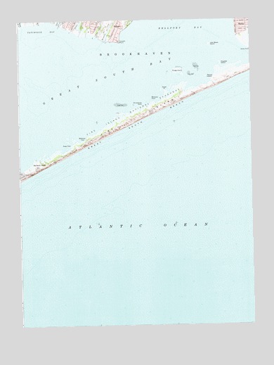
Howells Point, NY USGS Topographic Map
Click on map above to begin viewing in our Map Viewer.

This topographic map contains these locations and features:
Feature Name Type Latitude Longitude GNIS ID View Map
Abets CreekStreamN40.7479°W72.9771°942126View Map
Bayberry DunesPopulated PlaceN40.6898°W72.9893°943202View Map
Bellport Life Saving Station (historical)LocaleN40.7128°W72.9306°2358862View Map
Goose PointCapeN40.7209°W72.9207°951369View Map
Hedges CreekStreamN40.7440°W72.9671°952528View Map
Hospital IslandIslandN40.7320°W72.8909°953268View Map
Howells CreekStreamN40.7415°W72.9537°953324View Map
Howells PointCapeN40.7415°W72.9454°953325View Map
John Boyle IslandIslandN40.7401°W72.8968°954058View Map
Long CoveBayN40.6984°W72.9743°955848View Map
Molasses PointCapeN40.7173°W72.9284°957493View Map
Mud CreekStreamN40.7490°W72.9871°958002View Map
Otis Pike Fire Island High Dune WildernessReserveN40.7237°W72.8960°2035118View Map
Pelican IslandIslandN40.7265°W72.8987°960113View Map
Ridge IslandIslandN40.7293°W72.9140°962495View Map
Robinson CoveBayN40.7018°W72.9654°962664View Map
Swan RiverStreamN40.7479°W72.9973°966890View Map
Whalehouse PointCapeN40.7151°W72.9343°970969View Map

Note: Coordinates in the location and feature list above are referenced to NAD83 datum.


Copyright (C) 2008-2024 Ryan Niemi / Sunset Dynamics ... All Rights Reserved