TopoQuest Logo
Do you find TopoQuest useful?
Help keep TopoQuest running and adding new maps/features by donating!
Bitcoin:  19c7KJd3qBynnjoSw5npx9KScwjBe4ifkT
Litecoin:  LXs6TkuXGGXo1vDsWCkWVdjQX94eUKd6ui
Home View Maps Find Maps Find Places Resources & Links


Huachuca Peak, Arizona Topographic Map

USGS Map Title: Huachuca Peak, AZ
USGS Map MRC: 31110D4
DRG (GeoTIFF) Download: o31110d4.tif


Neighboring USGS Topographic Map Quads:


  O'Donnell Canyon, AZ  
31110E5
 

  Pyeatt Ranch, AZ  
31110E4
 

  Fort Huachuca, AZ  
31110E3
 

  Canelo Pass, AZ  
31110D5
 

  Huachuca Peak, AZ  
31110D4
 

  Miller Peak, AZ  
31110D3
 

  Lochiel, AZ  
31110C5
 

  Campini Mesa, AZ  
31110C4
 

  Montezuma Pass, AZ  
31110C3


Map MRC Location:

N32°
W111°
N32°
W110°
H8 H7 H6 H5 H4 H3 H2 H1
G8 G7 G6 G5 G4 G3 G2 G1
F8 F7 F6 F5 F4 F3 F2 F1
E8 E7 E6 E5 E4 E3 E2 E1
D8 D7 D6 D5 D4 D3 D2 D1
C8 C7 C6 C5 C4 C3 C2 C1
B8 B7 B6 B5 B4 B3 B2 B1
A8 A7 A6 A5 A4 A3 A2 A1
N31°
W111°
N31°
W110°

Huachuca Peak, AZ USGS 1:24K Topographic Map Preview:
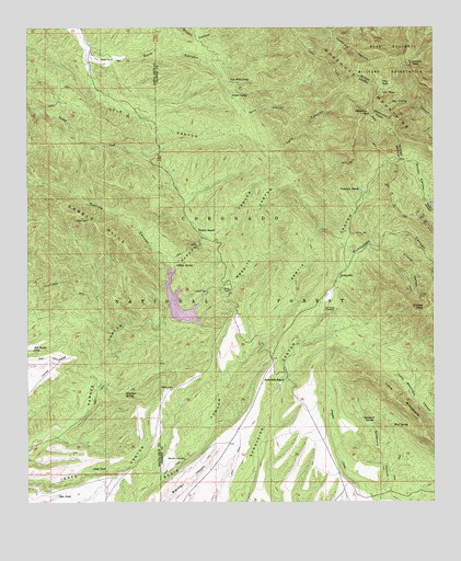
Huachuca Peak, AZ USGS Topographic Map
Click on map above to begin viewing in our Map Viewer.

This topographic map contains these locations and features:
Feature Name Type Latitude Longitude GNIS ID View Map
Beckers FollyReservoirN31.4807°W110.4906°2680449View Map
Bill Woods TankReservoirN31.4151°W110.4989°26335View Map
Collins CanyonValleyN31.4362°W110.4567°27817View Map
Collins SpringSpringN31.4374°W110.4552°27818View Map
Collins TankReservoirN31.4572°W110.4878°36591View Map
Concrete TankReservoirN31.4664°W110.4731°2680456View Map
Crest TrailTrailN31.4965°W110.4159°28171View Map
Eureka CanyonValleyN31.4426°W110.3912°28927View Map
Eureka MineMineN31.4290°W110.3801°28929View Map
Eureka PeakSummitN31.4262°W110.3815°28932View Map
Huachuca MountainsRangeN31.4890°W110.4081°30262View Map
Huachuca PeakSummitN31.4904°W110.3823°30263View Map
Inez TankReservoirN31.3771°W110.4911°30388View Map
Joiner CampLocaleN31.4826°W110.4331°30595View Map
Jones MesaSummitN31.4145°W110.4887°30606View Map
Judy TankReservoirN31.3839°W110.4806°30638View Map
Korn CanyonValleyN31.4959°W110.4826°30810View Map
Lake View Recreation SiteLocaleN31.4284°W110.4520°39209View Map
Lone MountainSummitN31.4084°W110.3967°31203View Map
Lone Mountain CorralLocaleN31.4176°W110.4050°2680454View Map
Lyle Canyon Trail One Hundred TwentyTrailN31.4640°W110.4229°39211View Map
Lyle PeakSummitN31.4823°W110.3912°31411View Map
Menefee WindmillLocaleN31.3865°W110.4520°31710View Map
Merritt CanyonValleyN31.4257°W110.4548°31716View Map
Middle CorralLocaleN31.4108°W110.4533°2680455View Map
Mud SpringSpringN31.4423°W110.3923°39217View Map
Mud SpringSpringN31.4421°W110.3923°32097View Map
Neighbor SpringSpringN31.4043°W110.4706°32278View Map
Parker Canyon DamDamN31.4270°W110.4554°39219View Map
Parker Canyon LakeReservoirN31.4244°W110.4528°39220View Map
Parker Canyon Lakeshore Trail HeadTrailN31.4235°W110.4475°2680451View Map
Parker LakeLakeN31.4267°W110.4555°41845View Map
Parker RanchLocaleN31.4470°W110.4479°32695View Map
Peterson PeakSummitN31.4773°W110.3973°32827View Map
Peterson RanchLocaleN31.4573°W110.3984°32828View Map
Pine ParkFlatN31.4854°W110.3917°32960View Map
Rattlesnake PeakSummitN31.4266°W110.3753°33400View Map
Rock Bluff Recreation SiteLocaleN31.4354°W110.4545°45016View Map
Rock Bluff Trail HeadTrailN31.4330°W110.4529°2680452View Map
Sawmill CanyonValleyN31.4534°W110.3765°34104View Map
Sawtelle TankReservoirN31.4909°W110.4917°2680448View Map
Scotia CanyonValleyN31.4168°W110.4312°34161View Map
Scotia CorralLocaleN31.4442°W110.4131°2680457View Map
SunnysidePopulated PlaceN31.4340°W110.4051°34962View Map
Sunnyside Canyon TrailheadTrailN31.4424°W110.3958°2680453View Map
Sunnyside CemeteryCemeteryN31.4257°W110.4092°34964View Map
Sunnyside RanchLocaleN31.4079°W110.4220°34965View Map
Sycamore CanyonValleyN31.3765°W110.3912°35012View Map
Sycamore SpringSpringN31.3975°W110.3976°35044View Map
Tom Willis CampLocaleN31.4859°W110.4379°35361View Map

Note: Coordinates in the location and feature list above are referenced to NAD83 datum.


Copyright (C) 2008-2025 Ryan Niemi / Sunset Dynamics ... All Rights Reserved